Toggle navigation
Home
(current)
Articles
(current)
Trip Reports
(current)
Search
Guest User
Sign-in
Register
Search Results
Filter
Activity Type
Alpine Skiing (96)
Cross Skating (14)
Hiking (20)
Mountain Biking (73)
Nordic Skiing (307)
Off Piste Skiing (23)
Road Cycling (289)
Roller Skiing (126)
Running (21)
Ski Touring (293)
Orientation
East (204)
North (105)
North-East (78)
North-West (119)
South (88)
South-East (68)
South-West (93)
Various (230)
West (188)
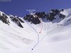
Pic de la Belle Etoile south couloir from Rivier
Classic spring ski tour with a sustained slope at the end.From the village take the GR549 to the north (Pays Tour des Lac des Sept Laux).
2013-04-03 19:13:04
Exploring the tracks between Crolles and la Terrasse
A short circuit to explore some of the tracks between Crolles and la Terrasse but generally staying in the valley.
2013-04-02 19:14:47
Autumnal Cold
Despite a persistent cold I wanted to take advantage of this wonderful autumn day. Nothing difficult. Superb countryside with the Chartreuse and especially the Belledonne as backdrops.
2013-04-02 19:05:38
Coteau de la Terrasse
Decided to give skiing a rest due to the poor refreezes over the last couple of days and get the MTB out for a 28km route starting at the house and going down the Gresivaudan valley towards la Terrace
2013-04-02 19:00:59
Côteau de la Terrasse by the valley
From Crolles Town Hall take cycle path to the Chateau de Bernis then track to les Echelles.
2013-04-02 18:43:52
Tete de Bostan, normal route
Park at L'Erigné as close to the end of the road as you can, then follow the summer road upwards towards the Lac des Mines d'Or (signposted), this road is pisted into a walking track regularly i
2013-04-02 11:42:37
Pointe du Gargotton, Couloir NW
From Mollard Ciseaux climb the road towards Prodin. At the hairpin at 1080 meters continue to the Trois Sources.
2013-04-01 22:29:11
Combe de Giclard
Tour near home with Chris who didn't know the Giclard route. We started low to add some vertical.
2013-03-30 23:05:39
Barres de Tencovaz
I'd been away for a few days, bad weather so no skiing lost. I got back around noon on Wednesday. A glorius day of sun and blue skied. Not too warm. Maybe a chance to get in a quick west face.
2013-03-30 11:39:42
Mont Granier from Tencovaz
ClimbFrom the Station du Granier, when the resort is open you are not allowed to climb on the ski runs. This is pretty strictly controlled by the pisteurs.
2013-03-30 00:03:03
Previous
114
115
116
117
118
119
120
121
122
123
Next