Toggle navigation
Home
(current)
Articles
(current)
Trip Reports
(current)
Search
Guest User
Sign-in
Register
Search Results
Filter
Difficulty
1 (18)
Activity Type
Hiking (1)
Mountain Biking (9)
Road Cycling (2)
Snow Shoeing (6)
Orientation
East (1)
North (2)
North-East (1)
North-West (1)
South (4)
South-East (1)
Various (8)
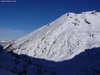
Point Arpire
Climb the combe d'Arpire to the south until to reach the col then follow the short ridge to right (west) to the summit.
2016-06-07 09:02:58
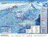
Chamrousse Nordic Park
http://www.chamrousse.com/nordique.
2015-12-06 09:56:07
la Mure des Molles
Starting from les Bletieres (or the Col du Lauteret) climb the trail to les Fournelles then the Rau (river) de Pre Boutey to the Col du Lauteret.
2014-12-29 20:04:29
Pravouta Tour
Start at the Col des Ayes car park after the final left hand hair pin about 400 meters before the col.
2014-10-24 09:33:06
Le No Name
From the reservoirs follow the broken tarmac road towards the Tour d'Arces. The track is very steep, around 15%. Continue past the tower and continue to the Pierre Grosse.
2014-10-02 18:45:06
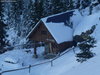
Jas des Lièvres, south face
Follow the road to the Pont de la Betta then a forest trail to the habert d'aiguebelle (refuge - unguarded). From here you can climb either by the east or south face.
2014-03-20 19:03:08
Mont St Mury
From the Col de Pré Long (1194 meters) take a forest path that joins the road at pt 1332 meters and from there to the parking la Souille at 1358 meters.
2013-11-29 23:22:11
Tour de St Hilaire, N-->S, Chartreuse, France
The climb from la Terrace or via the Chateau du Carré at Lumbin to St Bernard du Touvet is 7km over 635m giving an average of just over 9% but after km4 there is a 1km section at 11%.
2013-03-26 16:52:25
Previous
1
2
3
Next