The press and social media have been buzzing about avalanche fatalities in the Alps and beyond this winter with people calling for off piste skiing and ski touring to be more closely regulated or even banned. The French National Audit office has even suggested that mountain rescue should be charged but what is the reality behind the alarmist headlines?
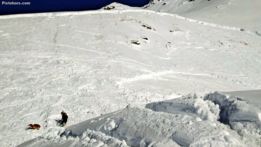 Large avalanches this winter, characteristic of persistent weak layer problems
We've been following the evolving snow and avalanche situation since early November. The last fatal avalanche accident in France occurred on 22 February 2026, bringing the seasonal total to 30 deaths in 24 incidents. The accidents occurred over a relatively concentrated period of less than two months, from 26 December 2025 to 22 February 2026.
This intensity contributed to significant media attention and, at times, a sense of alarm in public discussion. Yet while the number of fatalities is above the long-term average, it does not in itself represent a catastrophic season by historical standards. What makes the winter of 2025–2026 notable is less the absolute number of victims than the structure of the snowpack and the profile of the accidents.
A persistent weak layer that began forming in the late autumn remained present throughout the season. It produced a classic deep-instability scenario: long periods where the snowpack appeared stable, punctuated by destructive avalanche cycles when the layer was overloaded.
Today, more than two weeks after the last fatal accident, the snowpack across much of the Alps has largely stabilised. But the winter’s underlying weakness has not completely disappeared, and it may still influence avalanche conditions as the season transitions toward spring.
The story of this winter began long before the accidents.
In early November, cold clear conditions allowed weak layers of faceted snow to form at high altitude. These layers developed during a prolonged anticyclonic period that lasted well into December across much of the Alps.
Such weather patterns are ideal for producing persistent weak layers:
Under these conditions, snow crystals transform into angular grains or depth hoar (gobelets). When overloaded, say by the passage of a skier, they can collapse locally and this can propagate over a wide area, triggering a slide.
At the time, the snowpack was still relatively thin, and the weak layers remained mostly dormant. But once established, such layers can survive for months, especially at higher elevations and on colder slope aspects.
By late December the ingredients were already in place for a winter dominated by a structural weakness in the snowpack.
Between 7 January and 19 February 2026, the weather pattern changed dramatically.
According to Météo-France, this period saw a succession of active storm systems crossing the country. Several named storms affected France, bringing frequent precipitation and strong winds.
The result in the mountains was abundant snowfall. In many Alpine regions the snowpack became above average, with depths exceeding three metres above 2000 metres in some areas.
This loading phase occurred during an unusually warm winter:
These alternating periods of heavy snowfall, wind transport and to some extent rapid warming created ideal conditions for avalanche activity.
The deep weak layer formed earlier in the season was gradually buried under successive storm layers. With each storm, stress increased in the snowpack.
The period from the 10th January and the third week of February saw widespread avalanche activity across the Alps.
Large avalanches were reported in multiple massifs, sometimes reaching unusually low altitudes. Some were triggered naturally during storms, while others were triggered by skiers and snowboarders.
Several avalanches were described as exceptionally large. Such avalanches are characteristic of seasons dominated by persistent weak layers. Unlike typical storm slab cycles, which stabilise quickly after snowfall ends, deep persistent instabilities can remain sensitive for long periods and propagate across very large areas of terrain.
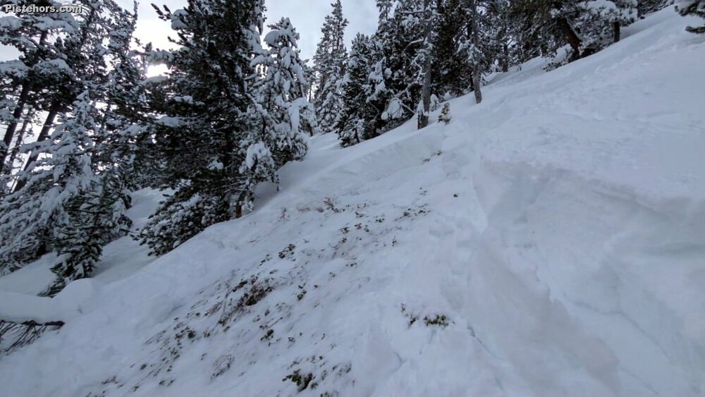 Widespread risk, even in the woods above Serre Chevalier
One striking aspect of this winter’s accidents is the profile of those involved.
Contrary to a common narrative that avalanche fatalities mainly involve inexperienced tourists, several incidents involved:
In one case, the victim was an experienced ski patroller. In another, two fatalities occurred among local French Alpine Club members.
Several fatal accidents also involved professional mountain guides and their clients.
This does not necessarily imply errors in judgement. Rather, it reflects the difficulty of managing a snowpack dominated by persistent weak layers.
Such layers can remain dormant for long periods and may be triggered only in very specific locations:
The result is a situation where many slopes appear stable for weeks, while a few isolated areas remain capable of producing large avalanches. That said, the winter storms also brought plenty of risk 4 and even risk 5 days which should have put back-country travellers on guard.
Another feature of the winter was the distribution of accidents across several danger levels.
Fatal accidents occurred during days rated:
This pattern is typical of persistent weak-layer seasons.
During storm cycles, avalanche danger ratings rise quickly and are widely perceived as hazardous. But when conditions improve and the rating falls, the remaining instability may become less obvious but still consequential.
At danger level 2, avalanches are expected to be rare and generally limited in size. However, if a deep persistent weak layer is triggered, the resulting avalanche may still be large.
This combination of low probability but high consequence is one of the most challenging avalanche problems to manage.
Since the last fatal accident, the snowpack in many Alpine massifs has evolved toward a more typical early spring regime.
Field reports from Météo-France forecasters in March 2026 in the Grandes Rousses and Lauzière massifs illustrate this evolution.
The main characteristics observed were:
In the Grandes Rousses, a snow profile at 2500 metres revealed a snowpack more than 2.3 metres deep, generally strong and well consolidated. Older weak layers were present but largely buried and not sensitive to triggering.
The avalanche danger rating has dropped to level 2 above 2200 metres.
The main concerns were limited to:
In the Lauzière, observers found that the persistent weak layer remained present but was now buried under approximately 1.5 metres of denser snow. Stability tests were negative, suggesting the layer was no longer easily triggered.
However, forecasters still warned that the weak layer could be triggered locally by:
In practical terms, the avalanche problem has shifted rather than disappeared.
The widespread storm-driven instability of February has largely subsided. The snowpack has settled and consolidated.
But the persistent weak layer remains part of the snowpack structure.
For backcountry travellers this means the risk has become more localised and less obvious:
At the same time, isolated large avalanches remain possible if the buried weak layer is triggered in the right location.
The transition to spring typically reduces persistent slab problems as repeated melt-freeze cycles gradually destroy weak layers.
However, the process is not always smooth.
Warm spells, rain-on-snow events, or deep meltwater penetration can sometimes reactivate buried weak layers, particularly on southerly slope aspects.
Given the structure of this winter’s snowpack, the coming weeks will likely see:
In other words, the mountains are shifting from a winter pattern dominated by deep structural instability toward a spring regime governed by timing and temperature. However don't forget that in April the French mountains often see a return to unsettled conditions as the warm land battles the cold sea setting up winter storms. The PWL may not have had its last word.
The avalanche season of 2025–2026 in the French Alps was shaped by a persistent weak layer that formed early in the winter and remained active for months.
A series of storms during January and February loaded the snowpack and triggered a widespread avalanche cycle that produced 30 fatalities between 26 December and 22 February.
Since then the snowpack has largely stabilised, and conditions in many areas now resemble a typical early spring pattern.
Yet the underlying weakness that defined the season has not completely vanished.
For those heading into the mountains in the coming weeks, the lesson of this winter may be that avalanche danger does not always announce itself loudly. Sometimes it lingers quietly in the structure of the snowpack, waiting for the right combination of terrain, load and timing.
The lesson for next winter is to follow the conditions as they evolve from the first snows of autumn. Variations in avalanche fatalities are very weather dependent. The key thing to watch out for are thin, early season snowpacks with long periods of dry, cold weather in the late autumn, early winter. This creates a widespread unstable layer.
We tracked the evolution of the snowpack since the end of October