Meteo France Bourg St Maurice has warned of a dangerous avalanche situation developing in the Savoie (and no doubt in other areas) for the coming weekend and early next week. As a reminder there has been no snowfall in the region for a month (the last significant snowfall was in early December). The high-pressure system has allowed the snowpack, which was thin at the start of the season, to experience clear, dry and particularly cold nights, especially over the past week. The surface of the snowpack on shaded slopes at altitude has reached -25°C, with air temperatures between -15 and -20°C. This has created a strong temperature gradient with snow metamorphosis in full swing. As a result, the snowpack contains large quantities of well-formed angular grains, ranging from large flat faces to gobelet. There are few slopes sheltered from the wind where you can find old powder snow (loose snow on flat faces) because recent wind episodes (repeated Foehn/Lombarde winds followed by north-westerly winds) have largely transported the surface snow.
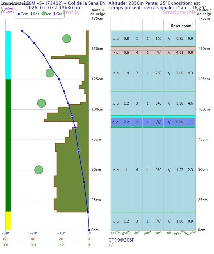 Snow profile Pointe de la Sana (credit: Meteo France BSM)
These transport episodes have given rise to numerous avalanches, both natural and accidental. Currently, most of the valleys are covered with hard snow. Many slopes are criss-crossed with old ski tracks that are now visible due to erosion, only the snow compacted by skis has resisted the strong winds. However, on these so-called cold slopes (west to east via the north at this time of year), the angular grains are only slightly buried. Sometimes they are only just under 10 cm of hard snow.
Heavy snowfall is expected from Thursday to Saturday. It will be accompanied by strong winds from the west or north-west. The additional weight of this snowfall on the existing snowpack will be considerable. In addition to the temporary instability linked to the characteristics of the snowfall itself (wind + temperature changes during the fall), the entire episode will rest on a particularly unstable snowpack. In the rather rare wind-sheltered valleys, the snow will rest directly on a persistent fragile layer (the famous rare slopes that until now had loose snow). On slopes battered by the wind (and therefore covered in hard/cardboard snow before the fall), instability will depend on the amount of fresh snow and the solidity of the previous hard snow. However, given the current conditions, the trend is towards widespread instability. Once sufficient snow has accumulated (from Thursday late afternoon in some places), different types of slabs are possible, in all directions and of all sizes (from 1 to 3). Many slabs will be in place within the fresh snow. This will represent a sufficient overload to mobilise the buried fragile layer, either directly or in a cascade. Avalanches may be triggered remotely, with large propagations and sometimes very deep breaks.
If you've followed so far you'll understand that the snow pack stability is about to take a severe turn for the worst. Take care! As ever detailed avalanche bulletins for France can be found here:
https://meteofrance.com/meteo-montagne/alpes-du-nord/risques-avalanche