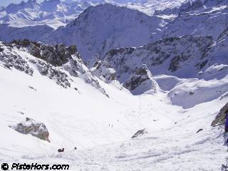
Ski-Areas > Northern Alps > Savoie (73) > Maurienne > Saint-Colomban des Villards > Selle du Puy Gris from Valmaure
From Valmaure climb to the Tepey chalets then follow the valley to point 1708 (IGN map). Follow the left bank of the valley leaving the Pierre Barme (1765m) on your left. Follow the bed of the Grand Pesson stream to cross through a gorge below the Rochers Bozon this leads into the final bowl leading to the Selle du Puy Gris (2758m).

You can descend the north side of the Selle to the col des Rochers. This keeps powder longer and often has a lower snowline due to the configuration of the valley.
| Mountain Range | Belledonne |
|---|---|
| Summit | Selle du Puy Gris |
| Altitude | 2758m |
| Orientation | South and East |
| Starting Altitude | 1205m |
| Vertical | 1505m |
| Maps | IGN TOP 25 3433 OT Allevard |
| GPS Waypoint | N 45.2959° E 06.1435° |
| GPS Route | Google-Earth:Saint-Colomban |
| Grade[1] | Danger: 1, Climb: PD, Ski: 2.2 |
| Snowboarders | Yes although the valley is a bit flat after the Pierre Barme |
| Equipment | ski crampons |
| Road Access | A43 -> St Etienne de Cuines -> D927 (col du Glandon) -> St Colomban -> les Roches -> Valmaure |
| Author | davidof |
We left Valmaure under a hot sun at 8am, it would have been better to have left around 7am and descend at 11am rather than 1 hour later. The valley was in good condition with 200 meters of portage.
This is a short video of the Selle du Puy Gris south side
Category: Trip Reports
<< Selle du Puy gris by the combe des Roches | Saint-Colomban des Villards | Col du Tepey from Valmaure >>