Ski Areas > Northern Alps > Belledonne > Pays d'Allevard > Col De Porte Off piste
This is a general template for ski routes.

Due to its closeness to Grenoble this a favourite spot for ski mountaineers many of whom head up here after the first snowfall. However despite the nearby ski pistes the mountain is not to be taken lightly. The steep slopes under the summit can avalanche so watch out. The mountain's distinctive shape and isolation make it particularly impressive and it is easily recognised from other ranges.
Most skiers start from the 1326 meter Col du Porte, but I wanted to add a bit of altitude and so parked just below the Chamchaude téléski about 3km from the small ski resort of Le Sappey? at 1240 meters altitude. It was Christmas eve and getting late. I'd been busy in Grenoble in the morning and the sun was already racing towards the horizon. As the tracks had already been made I figured that if I pushed it I could climb the 840 odd meters to the summit in a bit over an hour.
Ahead of me was a little group of skiers. As I drew closer I recognised Marco. We'd had dinner together the night before. This is his favourite route, it seemed he'd taken another afternoon of work to take advantage of the fantastic conditions. He was chatting to Marc, from nearby Le Sappey and a Franco-Irish girl called Audrey. Marc was climbing and the other two were coming down so I asked if I could team up for the climb. Safety in numbers.

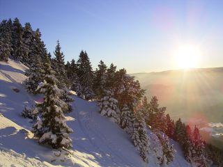
As we climbed through the pine forest the trees thinned and the slope got steeper. These trees would not be thick enough to stop an avalanche but above us the slope was not particularly steep. We started having to make conversions, good practise for trips later in the year. The snow on the slope above the trees was windblown and starting to form a crust, we'd have to hunt around for powder on the way down.

As the sun dipped lower towards the horizon we were now subjected to the full force of a cold north wind. This had brought snow a couple of days before. We stopped to put on more clothes. The slope turned hard and icy and at one point I was pushed backwards by the gale, only stopping myself by swiftly digging my poles into the slope. At a little after four in the afternoon we reached the summit ridge. From here a little climb on foot takes you to summit proper. The ridge can be dangerous later in the season as the strong westerly winds can form large corniches. We didn't hang around in the wind but removed skins, another skier, Geneviève, caught up with us.

We were tempted by the large slope, pregnant with snow beneath the avalanche protection. There wasn't a track which in itself was a sign. However the strong northerly wind would have been loading it with snow over the last two days and the late hour would severely inconvenience the rescue services should the worst happen. Instead we tracked down between the trees, there was still plenty of untouched powder to be hunted and a few stones underfoot.
| Mountain Range | |
|---|---|
| Summit | |
| Altitude | |
| Orientation | |
| Starting Altitude | |
| Vertical | |
| Maps | e.g. IGN TOP 25 3334 OT Chartreuse Sud |
| GPS Waypoint | |
| GPS Route | Google-Earth: |
| Grade[1] | Danger: 1, Climb: F, Ski: 1.x |
| Comments | 30° over 300 meters - source IGN 1:25000 map |
| Snowboarders | |
| Equipment | |
| Road Access | |
| Refuges | |
| Guide Books | |
| Author | |
| Website | http:// |
Add information about any outing here, include your name and the date of the outing
Contributed by _ on the _
<< History | Col de Porte | Charmant Som from les Cottaves >>