
Our article covering Météo-France's trip to Val Thorens to dig snow pits illustrates just one of the components that feeds into the next day's avalanche bulletin.The forecasters rely a lot on their own field observations as French ski resorts have yet to open, so the regular flow of observations from ski patrollers (pisteurs) is not yet established even if some resorts have started snow making.
The forecasters found that the snow block collapsed almost as soon as they began cutting it due to a fragile layer near the base of the snowpack that offered almost no resistance. It is interesting to note that avalanche forecast, prepared from this data, rated the danger at just 2 out of 5 above 2,800 meters, 1 below. The apparent contradiction illustrates how avalanche forecasting works, combining observations from individual snowpits with weather data, computer models and information gathered across an entire mountain range.
Conditions on the Cime de Caron were hardly inviting. Rain was falling as high as 2,800 metres, while much of the snow at lower elevations was wet or crusted.Above 2,900 metres, however, the snowpack had already developed a distinctly wintry structure.
Météo-France issued its avalanche bulletin for the Vanoise massif, valid for Friday 13 November. How could the danger be relatively low when the snowpack had collapsed so readily during testing? The answer lies in the difference between instability at a particular location and avalanche danger across an entire mountain range. The bulletin confirmed the presence of persistent weak layers on high-altitude north-facing slopes. These remained close enough to the surface to be disturbed by a skier. An avalanche could release around 30 cm of snow, or as much as 50 cm in some areas between the Dent Parrachée and Grande Motte. However, the snow cover was still relatively thin and discontinuous, limiting both the extent of unstable slopes and the potential size of avalanches. The bulletin signalled Wind Blown Snow as the principal danger. Météo-France therefore expects mainly small avalanches (size 1), with occasional medium-sized releases (size 2) possible. Rain and a partial refreeze had helped stabilise the snowpack lower down.
A single snowpit reveals conditions at one particular location. Just a few hundred metres away, the structure of the snowpack may be very different. Wind, altitude, slope orientation and terrain all influence how snow accumulates and transforms. Forecasters must therefore build a regional picture from individual observations, meteorological measurements and snowpack modelling. As the ski resorts open, reports from pisteurs will provide a more extensive flow of information. Until then, observations from ski tourers and other mountain users are especially useful. The Bourg-Saint-Maurice team have asked the ski touring community to continue sharing observations, explaining how valuable these are for producing its avalanche bulletins.
The Cime de Caron investigation highlights another important aspect of early-season forecasting: the snow falling now may influence avalanche conditions for months to come. Persistent weak layers formed in October or November can sometimes survive beneath subsequent snowfalls, particularly on cold, shaded slopes. For the moment, limited snow cover is restricting the avalanche danger across much of the Vanoise. But the weaknesses identified by Météo-France may become more significant if further snowfall buries them beneath thicker slabs.
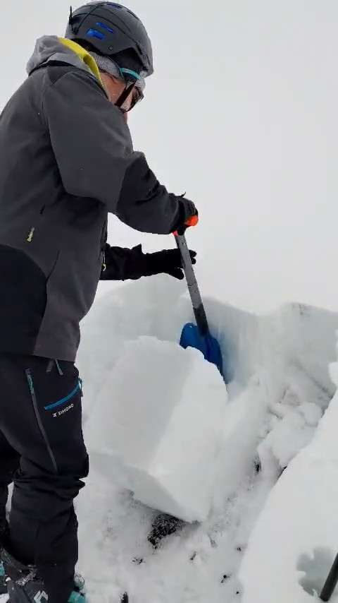 Rutschblock test on the Cime de Carron (source: Météo-France)