Thu, 16 April 2026
Vertical Climbed: 1,475 meters (4,839 feet)
Vertical Descended: 1,475 meters
Rating: 4
It felt ambitious for early season—just over 100 km on the bike but the route had a certain logic to it: two halves of roughly 50 km, stitched together by a single, steady climb of more than 1,000 meters up to the Tour Matagrin. Manageable on paper. A little more uncertain in reality.
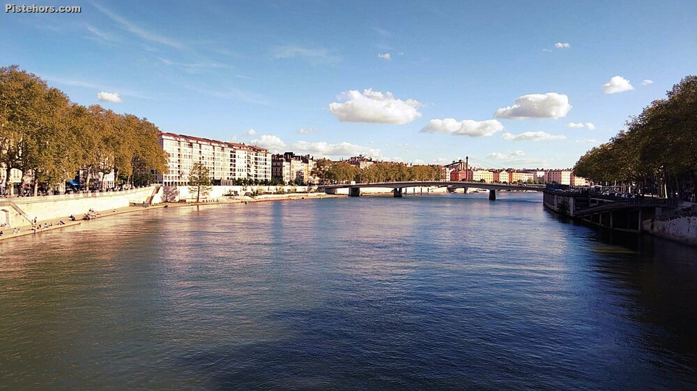
That uncertainty began almost immediately. Rolling out of Lyon, I realised I hadn’t downloaded the GPX route to my bike computer. What I had instead was an old version, close enough to be reassuring, vague enough to be problematic.
The opening kilometres followed familiar ground: the gradual drag up towards Tassin-la-Demi-Lune. (The name, incidentally, dates back to the 18th century and refers to a crescent-shaped defensive earthwork, une demi-lune, built as part of Lyon’s fortifications.) From there, though, the route diverged. Instead of the quiet back roads towards Charbonnières-les-Bains, I found myself on the much busier Route de Saint-Bel, a steady, traffic-lined climb to a low col before dropping into Saint-Bel.
Twenty-five kilometres done. A quarter of the ride already in the legs.
Beyond Saint-Bel, the ride changed character completely. The traffic faded, the roads narrowed, and the route began to trace the contours of the Monts du Lyonnais through villages with names that hint at deeper histories; Saint-Romain-de-Popey among them, likely tied to ecclesiastical land ownership rather than any direct papal presence.
In Saint-Forgeux, preparations were underway for a car rally, a familiar hazard in these hills. More than once, I’ve had routes blocked entirely by rally stages, but today the timing worked out.
From there, the real climb began.
Four hundred metres above sea level became one thousand over the course of 14 kilometres. It wasn’t a steady alpine-style ascent; instead, it came in ramps, short, steep sections that forced the pace, followed by brief respites that never quite let you recover. This is the quiet brutality of the Tarare hills: less spectacular than the Alps, perhaps, but no less demanding.
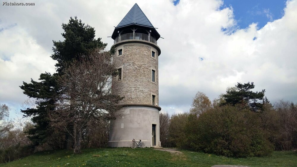
At the top sits the Tour Matagrin, perched on the summit of Mont Boussuivre.
The mountain itself rises to just under 1,000 metres, a rounded summit marked by a clearing and dominated by the stone tower. Built in 1876 as a hunting lodge for a local notary, the tower has lived several lives: a private retreat, later a military and aviation landmark, and today a restored viewpoint complete with a 360° orientation table. For a time, its conical slate roof disappeared, lost during the Liberation, before being reinstated in 2012, returning the structure to its original silhouette.
There’s history underfoot too. The site was once used as a triangulation point for mapping France, and a Napoleonic-era marker is still embedded in the tower’s masonry. Even the name Boussuivre carries echoes of the past, evolving over centuries from medieval records and giving its name to the stream that rises here before descending towards Tarare.
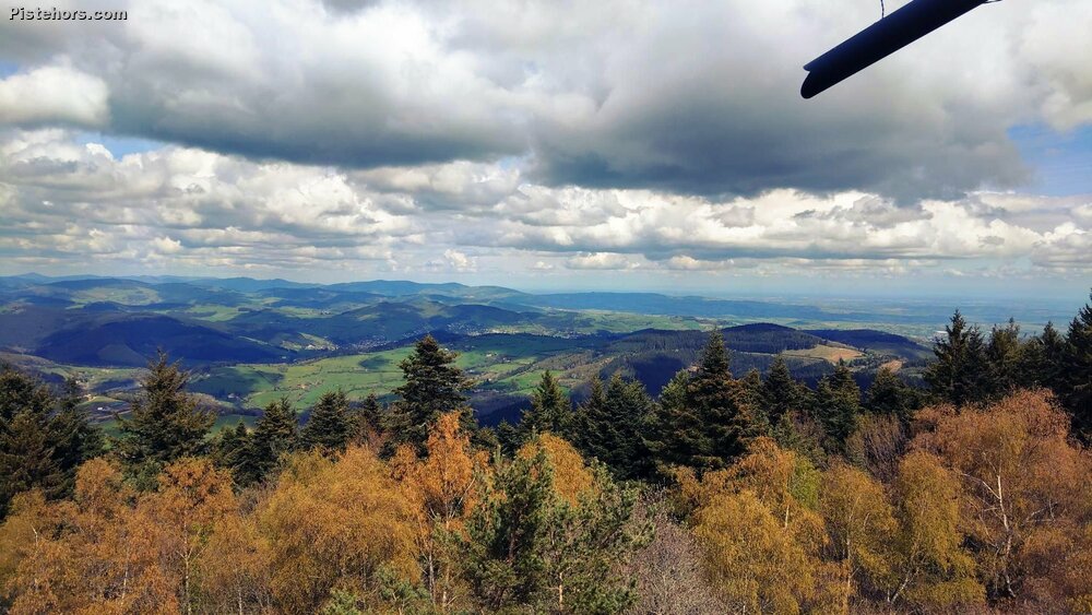
But it’s the view that defines the place. On a clear day, the Alps rise to the east, the Mont Blanc massif unmistakable above the haze, while closer ranges: the Beaujolais, the Pilat, the Forez, roll away in every direction. Today, the air carried that early spring clarity: cool, slightly hazy, but open enough to suggest distance.
The final kilometre to the summit leaves the tarmac behind, cutting through the woods on a gravel track, a fitting approach to a place that feels just removed enough from everything.
For the return, I handed control over to Google.
It suggested a different line: via Villechenève, where I stopped at the village shop for a drink, then on to Montrottier and Bessenay. The latter stood out, a lively village square, cafés spilling onto it, a sense of local life that contrasted with the quiet isolation of the climb.
There was, however, a trade-off. A 7 km stretch along the N89 to rejoin Saint-Bel, partially softened by a cycle path but still busy enough to demand attention.I could have ridden back over the col du Luere which I know well for a more direct and quieter return but it is around 775 meters and maybe climb too far.
Saint-Bel itself feels caught between identities. It could be a charming village, but the main road cuts straight through it, lined with takeaway shops and constant traffic. Functional rather than picturesque.
What the new route lacked in charm, it made up for in terrain: nearly 32 kilometres of descending back to Saint-Bel. From there, another long drop, around 15 km, from Le Guéret down towards Vaise. Fast, flowing, almost effortless riding albeit in always present traffic.
The temperature told its own story of the day. Up in the hills, it hovered around 14°C, cool enough for a jacket. Back in Lyon, it was closer to 20°C, the city already leaning towards summer.
From Saint-Bel, there was one final effort: the steady climb back up to Le Guéret, eased slightly by the presence of a cycle path. Then the reward, a rolling, uninterrupted descent all the way back into Lyon, the only obstacles being the occasional slow-moving car.
After hours out in the quiet folds of the countryside, the return to the city felt almost abrupt. Traffic, noise, movement, civilisation reasserting itself.
20C in Lyon. 14C on the mountains although it felt colder under the influence of a north wind. Some clouds but dry.