This is an archive of the old PisteHors.com forum

News | Gear | Ski Areas | Hiking | Mountain Biking
Powered by Google™
   
1 of 2
1
December 2010 Snow Conditions
Posted: 03 December 2010 11:10 PM  
Administrator
RankRankRankRank
Total Posts:  2234
Joined  2003-10-24

We’ve had a lot of snow around here over the last week giving some excellent ski conditions, even down to quite low levels. People have been urban skiing in Geneve, Annecy and Grenoble.

In the Northern Alps snow has come in 4 waves since last Friday. Over Friday/Saturday 30 to 50 cm, followed by another dump of 10-20cm on Sunday and 30-50cm on Wednesday and a further 10-15cm today. Best condtions in the pre-alps but some considerable to high avalanche risk.

DSCF3409.JPG height=480 width=640

Fine weather tomorrow (4 Dec) then wind turning round to the south with the prospect of heavy rain to 2300 then 2700 meters on Monday. Not great.


Posted: 04 December 2010 12:11 AM   [ # 1 ]  
Administrator
RankRankRankRank
Total Posts:  2234
Joined  2003-10-24

Here are some pictures from the Sancy avalanche on the 28th/Nov I talked about in the November snow thread.

http://lescafrancois.over-blog.com/


Posted: 04 December 2010 10:46 AM   [ # 2 ]  
Jr. Member
RankRank
Total Posts:  45
Joined  2010-01-22
davidof - 03 December 2010 11:10 PM

Fine weather tomorrow (4 Dec) then wind turning round to the south with the prospect of heavy rain to 2300 then 2700 meters on Monday. Not great.

Yuck. Didn’t this happen 2 or 3 seasons ago? I remember it raining high above Flaine (and many other places) in late December. There were some nasty avalanche conditions for weeks (if not months) after that with snow falling on icy crust. It looks like there is much more of a base this time so hopefully the long term effects won’t be as bad.


Posted: 07 December 2010 09:41 AM   [ # 3 ]  
Administrator
RankRankRankRank
Total Posts:  2234
Joined  2003-10-24

The zero isotherm has been around 2300-2500 meters over the last 24 hours and torrential rain has left its mark on the mountains as this, not very good photo, of the Jura shows. There doesn’t look to be much left skiable below 1800m.

jura.jpg height=154 width=640

The Chartreuse has lost 40cm of snow depth (50->10cm) at 1800 meters. A lot of this will be compaction of the fresh snow but it is not great.  It has also been extremely windy at altitude since Sunday, winds of 60-80km/h moving a lot of snow around.

Saturday was great touring weather, even if the avalanche conditions were a bit sketch. This shot from Bellecombe shows the southern end of Le Granier.

DSCF3413.JPG height=480 width=640

I climbed on the forest trails up to the large rock outcrop you see in the center then skied down through the forest.

Sunday we spent on piste due to the avalanche risk. Fantastic snow conditions for the start of December even if the foehn had started to blow.

For the rest of the week, it will turn colder on Thursday but with little fresh snow; however the weekend will be warm at altitude with a temperature inversion (cold air sitting in the valleys, warm air higher up). Not great prospects for skiing although a refreeze may produce some “spring skiing” in the afternoon on south->south/east facing slopes.


Posted: 08 December 2010 09:57 AM   [ # 4 ]  
Administrator
RankRankRankRank
Total Posts:  2234
Joined  2003-10-24

The rain and warm temperatures have overloaded the snowpack in places as these residents in St Foy found out yesterday

http://www.ledauphine.com/savoie/2010/12/07/avalanche-tout-pres-d-un-hameau-on-a-frole-le-drame

So in 48 hours we’ve gone from February in November to May in December. Where there is skiable snow (look above 1800 meters) the going is a mix of mank, spring snow and crust.


Posted: 08 December 2010 02:09 PM   [ # 5 ]  
Administrator
RankRankRankRank
Total Posts:  2234
Joined  2003-10-24

And a mountain chalet wiped out in Switzerland by a mud and snow slide in the Valais:-

http://www.blick.ch/news/schweiz/westschweiz/paar-ergreift-durchs-fenster-die-flucht-162216

The couple who were sleeping in the “shack” escaped through a window.


Posted: 09 December 2010 05:24 PM   [ # 6 ]  
Administrator
RankRankRankRank
Total Posts:  2234
Joined  2003-10-24
Steve Haigh - 04 December 2010 10:46 AM

davidof - 03 December 2010 11:10 PM

Fine weather tomorrow (4 Dec) then wind turning round to the south with the prospect of heavy rain to 2300 then 2700 meters on Monday. Not great.

Yuck. Didn’t this happen 2 or 3 seasons ago? I remember it raining high above Flaine (and many other places) in late December. There were some nasty avalanche conditions for weeks (if not months) after that with snow falling on icy crust. It looks like there is much more of a base this time so hopefully the long term effects won’t be as bad.

It seems to be a regular event at the start of December, normally a big foehn that melts everything but artificial snow. It is a real bummer.

It has got colder today, zero isotherm around 800 meters, which will help preserve what snow is left below 2000m while we wait for the possibility of some fresh snow from Tuesday 14th/Dec. However warm weather is promised for the weekend. Maybe a chance to get some spring skiing in?


Posted: 10 December 2010 09:25 PM   [ # 7 ]  
Administrator
RankRankRankRank
Total Posts:  2234
Joined  2003-10-24

As an indication of how delicate the conditions are now Briancon Escalade has posted news of an accident involving a ski tourer on the Peygu

http://brianconescalade.free.fr/?peygu2010

A ski tourer from Briançon was killed today on the petit Peygu, above the combe du Malazen (Laus de Cervières) at around 2400 mètres. He slide over 200 meters on ice hard snow before hitting a tree. Rain from the start of the week followed by cold have produced very dangerous conditions. Take care above 2000 meters where many routes are very icy. There are also slabs on all aspects above 2400/2500 meters

see photos on skitour: http://www.skitour.fr/sorties/tete-des-raisins,29952.html


Posted: 12 December 2010 12:53 PM   [ # 8 ]  
Administrator
RankRankRankRank
Total Posts:  2234
Joined  2003-10-24

Yesterday we ski toured to the Grand Vans (2350 m) behind Chamrousse from the Casserouse parking. The idea was to start relatively high (1400 meters) on a sheltered N/W facing slope. There was around 20cm of hardpack at the bottom of the pistes, a day for ski crampons on the steeper sections. The conditions were better overall compared to the same time last year when I’d done the same tour. A few rocks were showing lower down but overall it was pretty acceptable above 1600m.

Conditions on north faces, ridges and summits are a bit wind scoured. You noticed a lack of snow on any outcrop exposed to the wind. We’ve had a couple of days of Southerly winds at the start of last week and these turned NW then W with a lot of snow transport above 2500 meters (visible from the valleys).

DSCF3435.JPG height=534 width=800

Spring snow conditions on south facing slopes and very skiable

DSCF3428.JPG height=600 width=800

This is Alain at 2200m in the Vans bowl.

This shot shows some interesting glowing balls on the lift powerline in the low winter sun.

DSCF3439.JPG height=600 width=800

The current snow will form an excellent base. A few flakes (10cm) are expected in the region over the course of Thursday/Friday. Maybe a bit more in the Jura and Haute-Savoie. There may be better snowfall in the Western Pyrenees and Massif Central. Conditions were ueber stable on south facing slopes. Above 2500m there has been a lot of snow with wind from S/NW/W directions so conditions are pretty sketchy. There has been more snow in the Savoie (Lauziere/Areches/Haute-Tarentaise).


Posted: 14 December 2010 11:00 PM   [ # 9 ]  
Administrator
RankRankRankRank
Total Posts:  2234
Joined  2003-10-24

The icy conditions have caused a number of serious incidents both on and off piste.

A man has been killed ski touring today in the Chartreuse. The man was climbing down a couloir on the north side of the Grande Sure when he lost his footing and fell 50 meters.

The weekend saw a number of incidents in addition to the ski tourer death at Cervières. A snowshoer suffered multiple injuries, including to the skull, after losing footing on icy snow. The women slid 20 meters before hitting a rock. The accident happened in the Gordolasque valley near the lac Niré.

An 11 year old girl was killed on piste at les Orres on Friday afternoon after sliding on ice and hitting a tree and a 23 year old died after hitting a post on a piste between Vars and Risoul. At Auron a snowboarder suffered severe head injuries after a fall near the col du Bouchier.


Posted: 17 December 2010 11:00 AM   [ # 10 ]  
Administrator
RankRankRankRank
Total Posts:  2234
Joined  2003-10-24

A quick update. There was about 5cm-10cm on Wednesday in the Northern Alps with another 20cm overnight. Wind is generally from the north, moderate force (40km/h) with some snow transport. You can see this on the snowcapt monitoring stations. This one at Val d’Isere shows at least as much snow being transported as fell from the ski. Beware of soft slabs with particular danger above 2000m given the sometimes glasslike surfaces and above 2300-2500m where weak layers persist.

Screenshot-3.jpg height=525 width=528

http://www.isaw.ch/index.php?nav=data_meteo_station_graph&lang=en&code=FCHE1


Posted: 19 December 2010 03:03 PM   [ # 11 ]  
Newbie
Rank
Total Posts:  3
Joined  2010-12-13

Down south there has been less snow in the last few days but it has fallen nice and vertical out of the sky. I know it falls tracked at Val but never new it fell from the skis, now I know. Thanks for that


Posted: 19 December 2010 09:05 PM   [ # 12 ]  
Administrator
RankRankRankRank
Total Posts:  2234
Joined  2003-10-24

On Saturday we toured to the Grand Rocher in the Belledonne above the microski resort of Barrioz. This is a pretty safe tour when the avalanche risk is high. There was about 30cm of fresh snow but conditions were a bit windblown once you climbed out of the trees. On the ridge line there was maybe a total of 10cm of cover with some cornices on east faces. We decided to ski down the <25 degree east face between the summit and the Col de Merdaret. You could certainly feel the hard base and the snow was “slabby” and broke away from the snow that had fallen on Wednesday and the icy base. Not bad skiing but not the best and it gave an idea of conditions higher up.

DSCF3452.JPG height=480 width=640
Sun setting on the Grand Charnier d’Allevard - 19 Dec 2010

Much warmer on Sunday. Zero iso was around 1200m. The wind from the S / SW moved a lot of snow off exposed slopes as you can see in the picture of the 7 laux below.

DSCF3451.JPG height=480 width=640

Monday thru Tuesday should remain acceptable but a foehn expected on Tuesday with heavy rain is over 2200 m on Tuesday night / Wednesday with warm but dry temperatures on Thursday. Aim high but take care above 2100m!


Posted: 21 December 2010 04:41 PM   [ # 13 ]  
Administrator
RankRankRankRank
Total Posts:  2234
Joined  2003-10-24

Two skiers have been hurt, one seriously, by an avalanche in the Samoëns ski area in the Haute-Savoie. The rescue services say the slide may have been due by warming temperatures. The zero isotherm is currently around 2200 meters.

Three ski tourers have been caught by an avalanche near Chamonix. The slide occurred in the combe d’Encrenaz in the Grands Montets sector. One of the skiers was carried 400m. He suffered from mild hypoxia and hypothermia.

[ Edited: 22 December 2010 11:55 AM by davidof]
 
 
Posted: 27 December 2010 01:12 AM   [ # 14 ]  
Administrator
RankRankRankRank
Total Posts:  2234
Joined  2003-10-24

We were out touring Boxing Day in the Belledonne. There was a lot of snow transport from N->S as you can see in this picture. About 30cm of fresh snow above 2000m.

DSCF3493.JPG height=230 width=640

Snow was pretty slabby close to the col d’Aigleton where we climbed and lots of evidence of natural snow purges.

DSCF3491.JPG height=481 width=640

the new snow was poorly bonded to the very hard base and ski cutting was enough to release the surface snow. Our route was pretty low angled and generally sheltered from the snow transport but a reminder this was a real risk 3 day.

We heard that Wayne Watson’s group in Val d’Isere had a serious incident at 2700m in the Combe de Signal in the Fornet. Two skiers taken by a slide. One triggered her airbag and remained on the surface. The other skier also had an airbag but was unable to trigger it and was buried under a meter of snow, he is in a very serious condition in Grenoble hospital tonight.

The combe is N/W facing so maybe less influenced by the N winds over the last 24 hours but the previous snowfall was accompanied by winds from the S. In the Val incident it seems that a secondary avalanche covered the skiers, with the airbag being visible on the surface. The first slide was 50 meters wide and a meter deep in places, the second slide seems to have been an old slab that took snow to ground level.

(edit: see extract of avalanche bulleting posted below which seems to confirm the two layer theory).

[ Edited: 27 December 2010 11:36 AM by davidof]
 
 
Posted: 27 December 2010 11:21 AM   [ # 15 ]  
Administrator
RankRankRankRank
Total Posts:  2234
Joined  2003-10-24

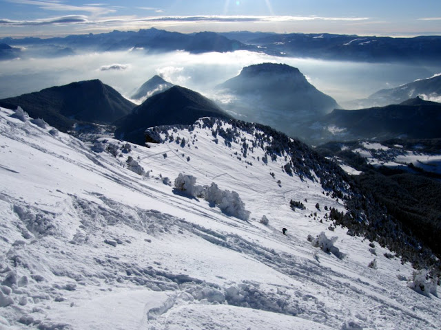
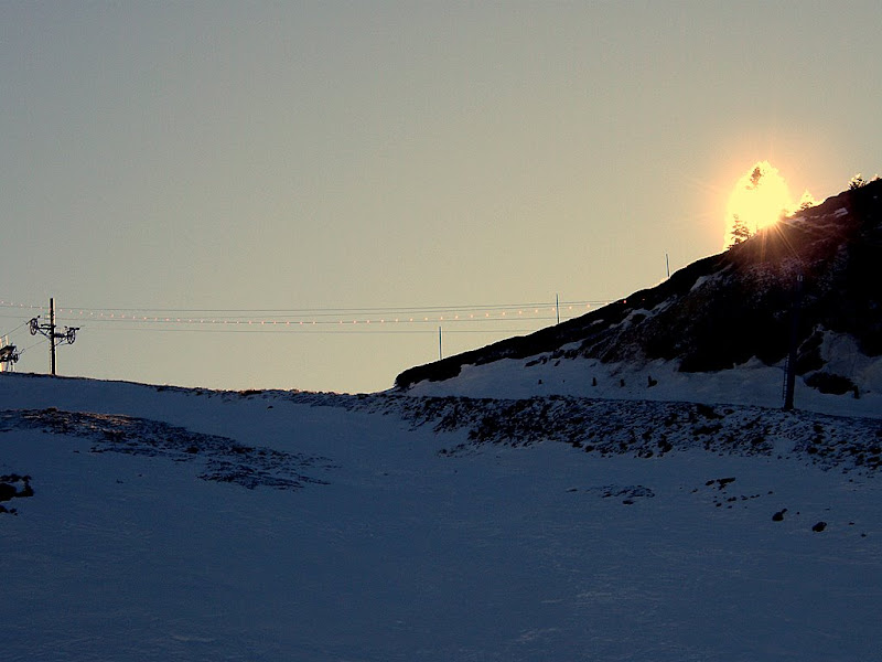
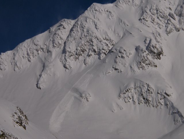
This photo from yesterday gives some idea of the likelyhood of skier triggered avalanches. Just under the rock (perhaps the wind had caused some snow build up) a small soft slab has gone but doesn’t have enough momentum to travel further than the (my) ski tracks below, then some sluffing as Guy skis down the slope.

Screenshot-4.jpg height=480 width=640

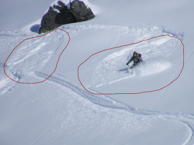
We were skiing a series of low angle pitches with benign run-outs. There didn’t seem to be a weak layer between the base and new snow (it had rained at this altitude) so the soft slabs did not have any energy to break over a larger area.

To round up the recent incidents:

Le Reposoir (Haute-Savoie). Three ski tourers heading for the col d’Ancrenaz triggered a slide at 10h40. Two of them were able
to extricate themselves from the slide and were able to locate the third victim who was completely buried. The victim was taken by helicopter to Annecy Hospital suffering from minor injuries.

At l’Alpe d’Huez two skiers triggered an avalanche around 15h00. One of the skiers suffered a number of injuries and was heliported to Grenoble hospital.

Three Dutch skiers were rescued from above cliffs at 1200m in the Romanche valley. They had skied from the top of Les Deux Alpes, following a route they had done the day before with a guide. Unfortunately they got lost on the way down. A British soldier was also rescued from les Contamines after spending an uncomfortable night in the open after getting lost.

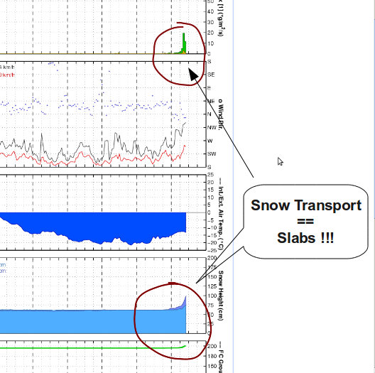
For reference here is an extract of the 73 avalanche bulletin (risk 3 > 2000-2300 meters)

STABILITY OF SNOW PACK

SLABS CONCEALED IN THE POWDER

Cumulative snowfall since Friday morning, approaching 15 to 30 sometimes 30 cm to 40 cm in the Vanoise, Maurienne and at alitude around 2500 meters. The snow fell almost no wind (North-East to East 20 to 40 km / h). However, the pisteurs sometimes got some good results in avalanche control above 2000/2500 m. An avalanche accident occurred on Friday in Vanoise (2250 m north).

Above 2000 to 2300 m, fragile sub-layers, cold snow the last 24 hours or angular grains a little deeper, show a marked instability in case of overload. Indeed, plaques formed recently by South East wind (foehn) are still present and now hidden under the snow. In addition, the north wind may aggravate the expected local situation with the formation of new surface slabs. Many slopes are therefore a potential risk of triggering the passage of skiers (sometimes only one can suffice). Suspicion, directed by steep north-east, north and west and in south to south-west with the possibility of rupture of fragile slabs (less than 20/40 cm) or more thick and hard (40/60cm).

Below 2000 to 2300 m, the snowpack is relatively stable with both the effect of the recent warm spell (with South foehn) and deep frozen well consolidated layers. However, the north wind may again encourage the formation of some surface slabs, especially when approaching peaks. Moreover, there are still old instabilities on steep slopes facing north (north-west to north-east) and in certain areas usually cold as in Haute Maurienne. It should therefore not ignore the risk of an accidental discharge with the passage of one or more skiers.

In the Grandes Rousse the risk was 3.

FORMATION OF HARD SLABS ....< br > Wind northeast strengthens this Sunday, and on the snow surface light and easily transportable in the morning, new soft slabs will form. In the north slopes, the presence of weak layers favors the triggering of small slabs. In south-east slope to southwest, it will be particularly vigilant because the brittle slabs, powdery in appearance are likely to trigger the passage of one or more skiers.


1 of 2
1