Snow and Avalanche Report: Week 12-2005
After the sun comes rain and what a change it has made to the mountains. With temperatures in positive territory below 2800 (3,500 meters in the Pyrénées) the snowpack was extremely humid yesterday off-piste to a relatively high altitude. Where the rain has percolated down to ground level the overloaded snowpack can easily slide off the mountains on any relatively steep slope and many routes that were passable with skis last weekend are now impractical. The mountains looked more like late rather than early spring yesterday although a dusting of snow above 1800 meters has given the slopes a wintry look once again this morning.
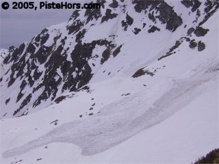
Wet snow slide, Belledone
Dangers remain powerful wet snow avalanches at mid-altitude where the snowpack is saturated with rain. The stability of snowbridges on glaciers should have improved somewhat with the recent fresh snow. Falls are also a risk as an accident in the Belledonne last Sunday illustrated although with limited overnight refreezing of the snowpack the risk must be greatest from small snow sluffs knocking a skier or snowboarder off-balance. Care should be taken on exposed routes.
Northern Alps
At 3000 meters, the la Plagne/Bellecote monitoring station has lost 20cm of snow depth over the last week. Perhaps more representative of skiing is the Aigleton station situated at 2240 meters in the Belledonne which dropped 25cm over the last six days and saw temperatures up to 10C with no overnight refreeze to stabilize the snowpack. Things have improved a bit over the last 24 hours with around 5cm of fresh snow and temperatures turning negative again.
The snowline has increased dramatically over the last couple of weeks with little skiing off-piste below 1400 meters. Snow depths are also below average at altitude and care should be taken when travelling on crevassed terrain. The recent snow should help to improve the situation high up.
All this rain has increased the risk of wet snow avalanches and any steep slopes that have not already purged should be suspect, particularly North through East and later West facing below 2500 meters. The zero isotherm will again climb to around 3000 meters during the day and further avalanches should be anticipated including sluffs at altitude on south facing slopes. The fresh snow at altitude has been accompanied by light winds.
Further to the South in the Oisans and Ecrins, where the snow pack is thin and a large layer of depth hoar has developed Météo France has recorded a number of avalanches involving skiers, although non-fatal.
Southern]http://pistehors.com/backcountry/wiki/Ski-Areas/Southern-Alps]Southern Alps[/url]
Just as some resorts in the Southern Alps such as Pra Loup have shut for the season the region has seen some snow. Observers reported a couple of hours in Montgènevre and Isola overnight although there has also been a lot of rain below 2600 meters. At the Col Agnel weather station (2630 meters) close to the border with Italy temperatures have finally turned negative and there is around 5cm of fresh snow. It is possible to ski to 1600 meters on North facing slopes but there is little remaining snow on Southern slopes below 2500 meters.
The zero isotherm is between 2300/2600 meters climbing to 2800 later in the day. Despite the poor overnight freeze the snowpack is more stable earlier in the day. The risk of snow sluffs and larger avalanches included slabs (especially on shaded slopes above 2600 meters) will increase during the course of the day, particularly where the sun hits the slopes. Some of these could be large. Winds has largely been moderate from the South-West.
Corsica
It has also been warm in Corsica and the spring melt has accelerated over the last few days with a little bit of snow above 2,500 meters. The zero isotherm is around 3,000 meters today which was accompanied by a strong south-west wind overnight in the south of the island.
Snow cover is still reasonable for the end of mark with 30 to 70cm of snow at 1500 meters however there is no freeze-thaw cycle below 2000 meters. There are still a number of fragile cornices which should be given a wide berth. The risk of wet snow avalanches on slopes that have not already been purged is high, especially in the Cinto-Rotondo range which has the created snow depth and also saw the bulk of recent precipitation. There are also some vestigial snowslabs on wind loaded and shaded slopes where the lower layers are weak (facetted snow).
Pyrénées
It is spring with a vengeance in the Pyrénées with around a meter snow depth being lost over the last couple of weeks. There is still over 350cm of snow at the Soum Couy (2150m) in the west of the range; witness to another excellent season for the mountains.
The weather is good, but very hot for the season with the zero isotherm rising to 3,500 meters in the afternoon coupled with a increasing south-westerly wind.
It is possible to ski to around 1400 meters on shaded slopes but there is little snow below 2000 meters on south facing slopes. Last night saw a good refreeze but the snowpack will rapidly become very humid during the course of the day. Backcountry travel and off-piste skiing should be restricted to the morning. There will be natural avalanches on South facing slopes even at high altitude and great care should be taken on all North sector slopes, especially bowls and couloirs which have not yet purged and which are still heavily loaded snow. Some avalanches will be very large and powerful, at 1500 meters the snow mass is around 600kg per meter cube. Backcountry travelers should remember the avalanche at la Mongie on the 12th which buried a snowboarder under 3 meters of snow. Rescue teams only recovered the victim 10 days later.
References
This information is a summary of current conditions and is provided for information only. It is based on direct observations and information from the following sources.
Météo France issues daily avalanche bulletins for the French Alps, Corsica and Andorra. You should ideally consult at least the previous 5 days bulletins prior to your trip in order to have an idea of recent conditions.
SkiTour conditions database, Camp2Camp and Bivouak have trip reports with observations of the snow conditions.
Weather information is complemented by the USAF Public Weather Charts
Henry’s Avalanche Talk publishes a daily translation of the Météo France bulletin for the Savoie area.
Les Sybelles Tourist office also has an English translation of the Savoie area avalanche bulletin.
Posted by
davidof on Friday, 25 March, 2005 at 10:48 AM
A Swedish skier was killed this morning after falling 30 meters into a crevasse on the Rognon Glacier, a variant of the of the popular Vallée Blanche route, after a snowbridge gave way at 3000 meters altitude. There was a similar incident in the early afternoon and the skier was lucky to escape unhurt.
Both incidents are a reminder of the poor conditions that persist at altitude.
Posted by
davidof on Friday, 25 March, 2005 at 10:14 PM
Teh organisers of “La Ski Ecrins Alpinisme” scheduled for the 10th of April have decided to cancel the event after checking out the course and seeing snow levels “more like mid-June”. The ski mountaineering competition was due to take place in the heart of the Ecrins National Park. They hope to run it in 2006.
source: [url=http://www.kairn.com]http://www.kairn.com[/url]
Posted by
davidof on Saturday, 26 March, 2005 at 12:34 PM
Page 1 of 1 pages
Comments are now closed