After a warm start to the week, we were skiing in excellent spring conditions on Tuesday, the weather has turned unsettled and colder with snow today above 1400 meters and with further snow forecast down to valley floors over the weekend. The south-westerly wind has shifted around to the north over the Alps and will strengthen over the weekend. There are powder conditions above 2000 meters but the strong winds have worked the snow where it is exposed leaving hard pack and wind crusts.
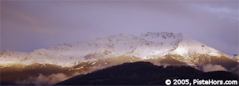
April Snow on the Sept Laux
The fresh snow, up to half a meter at altitude, in the pre-Alpes, Haute Savoie and exterior ranges such as the Belledonne, accompanied by strengthening winds from the South-West switching to the North over Friday/Saturday has created a complex situation. There is an increased the risk of hard and soft slab avalanches on a various aspects and altitudes. There is also the risk of powder avalanches and snow sluffs, especially on Sunday which will see some sunny periods but will continue to be cold. Exposed routes and terrain traps should be avoided where possible.
The greatest risk is at altitude in the Haute-Savoie but backcountry travellers should take care on any slope where there has been significant snowfall or accumulations. In particular close to ridge lines, at the base of cliffs and on rollovers.
The spring weather at the start of the week has created a freeze/thaw crust on south sector slopes. This will form a sliding surface for new snow and accumulations formed under the north winds on Friday and Saturday. There are also accumulations on north to north-east slopes (and north-west slopes close to the frontier with Italy). Above 2,300 meters the fresh snow has fallen onto a hard surface or onto unconsolidated layers.
The zero isotherm will be between 600m to 900m on Saturday with snow down to valley floors in places. Skiing is now possible from around 1200 meters on north facing slopes, there is no base below this altitude.
Southern]http://pistehors.com/backcountry/wiki/Ski-Areas/Southern-Alps]Southern Alps[/url]
Conditions are still well below average except at altitude despite some 15-20cm of fresh snow. The best conditions remain in the north of the region. It is possible to ski from 1800 meters on north facing slopes. Despite the lack of snow strong winds will form new slabs, above 2400 meters on northern slopes these will be on less stable layers and could cause a large, full-depth slide. Some sluffing and powder avalanches on steep slopes are expected, particularly on northern aspects or above 2000 meters on south facing slopes.
Ski touring is effectively over in the Alpes Maritimes except on shaded slopes above 2,500 meters. Skiers should watch out for accumulation and slabs close to ridges and summits on slopes from west, north through to east.
After a month of warm weather snow conditions in Corsica are below average below 1800 meters. It is possible to ski from 1600 meters. Watch out for shady icy slopes, especially where these are covered by a dusting of recent snow and for old, unstable cornices on ridgelines.
The snowpack is pretty stable but the freeze/thaw cycle has been fairly shallow. Groups should use good spacing on suspect slopes.
A weather system is moving west-east across the Pyrénées. With the Isotherm dropping from 2000 to around 800 meters snow will fall to around 500 meters. Around 30cm is expected accompanied by north-west to north winds. The mountains are skiable to around 1500 meters on shaded slopes but summits and ridges are bear of snow. The fresh snow is falling on a hard surface. The avalanche risk will be greatest in central and eastern areas. In central areas very strong, gusty northerly winds will form slabs on predominantly but not exclusively south to east slopes. These could be triggered by the passage of a single backcountry traveller. Towards the west the slabs will be slightly more stable and localized but good group spacing should be practised.
There is the risk of moderate wet snow avalanches on northern slopes over Saturday due to the new load of humid snow and purging and snow sluffs from Monday with the return of sunny conditions.
References
This information is a summary of current conditions and is provided for information only. It is based on direct observations and information from the following sources.
Météo France issues daily avalanche bulletins for the French Alps, Corsica and Andorra. You should ideally consult at least the previous 5 days bulletins prior to your trip in order to have an idea of recent conditions.
SkiTour conditions database, Camp2Camp and Bivouak have trip reports with observations of the snow conditions.
Weather information is complemented by the USAF Public Weather Charts
Henry’s Avalanche Talk publishes a daily translation of the Météo France bulletin for the Savoie area.
Les Sybelles Tourist office also has an English translation of the Savoie area avalanche bulletin.