This is an archive of the old PisteHors.com forum

News | Gear | Ski Areas | Hiking | Mountain Biking
Powered by Google™
   
 
January 2011 Snow Conditions
Posted: 02 January 2011 11:40 PM  
Administrator
RankRankRankRank
Total Posts:  2234
Joined  2003-10-24

Largely explained in this trip report.

http://pistehors.com/news/forums/viewthread/764/

Crust on south-west and east faces which don’t see enough sun. Transformed snow on south-east aspects. Some powder on south faces where the slopes have been sheltered from the wind.

Ridge lines are windswept. Heavy powder on north aspects but wind affected at altitude, for example on Thursday we had to descend from 2700m to 2350m to find powder snow, higher up the surface was wind scoured.


Posted: 07 January 2011 09:49 AM   [ # 1 ]  
Administrator
RankRankRankRank
Total Posts:  2234
Joined  2003-10-24

Fairly depressing conditions really. It was 8C overnight at Chamrousse at 1800 meters with a strong south-westerly wind. Looking at the monitoring stations we have lost around 10cm of snow cover at 2400 meters and only above 2500 meters are we seeing fresh snow. +10cm at 2600 meters in the Haute-Maurienne. Winds have been very strong - up to 80km/h. It is slightly better in the Southern Alpes, 20cm of fresh at 2250m in Orcieres. Expect some slabs at altitude, especially on North to East sectors above 2200-2500m and snow purges lower down as the snow pack has got overloaded with rain.


Posted: 08 January 2011 12:22 AM   [ # 2 ]  
Sr. Member
RankRankRankRank
Total Posts:  270
Joined  2008-01-31

Making me feel good about not being around the Alpes du Nord right now.

Georges said he skied Quermoz in the Beaufortain, didn’t make it sound terrible, but not so much snow left.

Ken


Posted: 10 January 2011 10:54 AM   [ # 3 ]  
Administrator
RankRankRankRank
Total Posts:  2234
Joined  2003-10-24

It is snowing from 1000m today, which is good, but below 1800m a lot of that snow is falling on bare ground.

I checked the local weather station records for the last decade. Saturday was officially 19.1C and is the hottest winter day (Dec-Feb). About 1C hotter than the last maximum. Quite impressive.


Posted: 10 January 2011 06:32 PM   [ # 4 ]  
Administrator
RankRankRankRank
Total Posts:  2234
Joined  2003-10-24

Just checking Vizille Meteo and the 10 Jan 2007 (was that the famous winter with no snow? which had hopeful early season conditions with winter finally arriving in March?) was also around the same temperature - high teens.


Posted: 13 January 2011 03:53 PM   [ # 5 ]  
Administrator
RankRankRankRank
Total Posts:  2234
Joined  2003-10-24

Le 8 janvier, les températures étaient dignes d’un mois d’avril en Rhône-Alpes . Une atmosphère printanière régnait dans le Centre-Est, où les températures observées se situaient 1°C à 2°C en-dessous des records de douceur.

Températures maximales relevées le 8 janvier 2011 :

19°C à Grenoble, Carpentras, Biarritz, Oloron, Figari.
18°C à Marignane, Avignon, Ajaccio, Luchon.
17°C à Lyon, Ambérieu, Mâcon.

Confirmation from Meteo France. Records broken in the Rhone-Alpes with temperatures 1 to 2C above the previous values.


Posted: 14 January 2011 05:27 PM   [ # 6 ]  
Administrator
RankRankRankRank
Total Posts:  2234
Joined  2003-10-24

P1000182.JPG height=234 width=640 6th Jan

P1000184.JPG height=229 width=640 7th Jan - Zoiks!

P1000197.JPG height=148 width=640 14th Jan, looking better


Posted: 17 January 2011 10:39 AM   [ # 7 ]  
Administrator
RankRankRankRank
Total Posts:  2234
Joined  2003-10-24

I finally got out Sunday taking an FFME group somewhere (finally les Roches de Rissou) after a week with a cold. It was a bit of a headache finding snow. Apart from ski runs there is not much below 1500m, on some shaded tracks you can ski down to around 1350m if you don’t mind hitting the odd rock. Conditions on South/East facing slopes are hard snow in the morning, transforming around 11-12am. Don’t ski down much later. There is still some heavy powder on north aspects but often with a light crust. I will post some photos tonight.


Posted: 17 January 2011 11:16 PM   [ # 8 ]  
Administrator
RankRankRankRank
Total Posts:  2234
Joined  2003-10-24

Anne Bauvois, one of the few female mountain guides sent this beta on the North Belledonne if you are heading that way:-

From the St Colomban villards. Take the Ressoutan road : 4X4 or with chains one stops between 1350 and 1500 meters. You ski to the car without scratching skis, about 1 hour on the road.

Col des Balmettes and breches des Roches Vallorins have spring snow conditions (ski down between 11am and 12pm). FYI: north couloirs of the Vallorins are crusty and icy (rain to 2500 meters?) With a layer of cold snow underneath, accumulations? -> Not a good plan.

In short, a beautiful wild valley where we were alone on Saturday.

The bistro is open St Colomban -> beer in the sun wink
Anne Bauvois - http://www.amountainguide.com/

Here is a view of the North Belledonne from Allemont looking left from the Pas de la Coches rightwards to the Aiguilles d’Argentiere (this side is hotter than the Columbans valley and has less snow cover).

belledonne.jpg height=229 width=800


Posted: 28 January 2011 11:30 PM   [ # 9 ]  
Administrator
RankRankRankRank
Total Posts:  2234
Joined  2003-10-24

This picture is typical of the conditions today, a thin layer of snow with often ice or very hard snow underneath

P1000322.JPG height=480 width=640

here is a look at the Chartreuse: dry as a bone

P1000327.JPG height=166 width=640

it has been a long time since it was this bad, even in 2007 there was some snow :-(.

If you are looking for powder you can find some on WNW thru NE slopes especially on slopes with mini valleys running down them where cross loading has collected some pockets. It is not particularly even which can make things challenging. Try and avoid steep overskied areas which have left scoured hardpack. Avoid any forests except for very open trails from 1400m.

Outlook is for maybe some snow over the weekend 5/6 February, until then sunny.


Posted: 29 January 2011 09:12 AM   [ # 10 ]  
Sr. Member
RankRankRankRank
Total Posts:  543
Joined  2006-01-24
davidof - 28 January 2011 11:30 PM

Outlook is for maybe some snow over the weekend 5/6 February, until then sunny.

A substantial snowfall onto some of the snowpack we’ve got right now could be pretty dangerous for the main Feb holiday time. In places you’re seeing a lot of near surface faceting in addition to facets at depth, it’ll take a little time for that to go into reverse and round out. In the meantime you could get new snow lying on some really shallow snowpacks and the concern would be that people miss the significance of that..

 Signature 

SwissMountainLeader.com & B&B L’Epicéa, Leysin, Switzerland


Posted: 29 January 2011 02:18 PM   [ # 11 ]  
Administrator
RankRankRankRank
Total Posts:  2234
Joined  2003-10-24

That is certainly a worry aftr such a long cold spell, I still t
hink the greatest danger will be above 2200 meters. If iT snows


Posted: 31 January 2011 06:26 PM   [ # 12 ]  
Administrator
RankRankRankRank
Total Posts:  2234
Joined  2003-10-24

Screenshot-1.jpg height=327 width=800

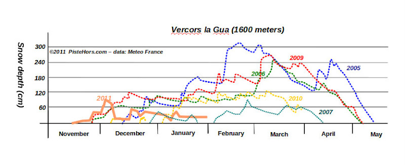
Here is a quick comparison of snow depths at 1600 meters (east side of the Vercors). After a cracking start this season is looking similar to 2007. That is: not good. Personally I would say there is less snow around this season compared to 2007 as the conditions below 1600m are actually worse.

You can find snow lying on flat ground from 1000m in very sheltered north facing slopes though.