Snow and Avalanche Report: Week 13-2005
Conditions in the Northern-Alps have improved slightly over the course of the week with slightly cooler temperatures a dusting of snow above 1500 meters on Tuesday although there has also been quite a bit of rain to 2000 meters. On Wednesday we found 15cm of snow off-piste at 2000 meters and Thursday saw good touring conditions in the morning with an overnight refreeze with a small covering of fresh snow from 1800 meters.
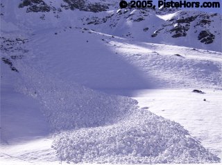
Avalanche from smooth rocks
Northern Alps
The zero isotherm is around 2000 meters with a light to moderate wind from the North-East. The conditions are generally good, it is still possible to ski from many trailheads with very little climbing. Snow begins around 1350 meters in the pre-Alps on sheltered slopes. The recent snow has improved conditions above 2000 m but they remain poor for the season. Pay attention to snow bridges on crevasses and icy slopes in the morning. The weather on Saturday will be excellent with the temperatures turning slightly colder towards the end of the weekend.
Powder, coupled with wind crust, can be found on northern aspects above 2000 meters. On southern aspects there is a freeze/thaw crust in the morning, this is breakable in some areas such as the Mont-Blanc massif, this transforms to spring snow over the course of the morning.
The main avalanche risks are wet snow avalanches over the course of the day. Ski tours should be completed early, especially at lower altitude where there is still quite a lot of snow and the snow pack is very humid. Routes should avoid smooth or grassy slopes later in the day.
There is also an increased risk of slab avalanches where there has been a lot of fresh snow, in particular above 2,500 meters in the two Savoys (particularly the Mont Blanc massif) and the Belledonne. Slabs have formed under the action of south-west winds over last weekend; the snow is sitting on a fragile layer on some steep north facing slopes above 2200 meters. More recently the northerly winds have formed some fresh slabs on south facing slopes above 2800 meters.
Update Monday 4th April: Risk of Slab Avalanches in the Vanoise Park
Lionel Allemand of Volopress noted a number of soft slabs above 2500 meters which are lying on facetted snow on the north face of the Bellecote near la Plagne. Three of their group were caught by a slab at 2900 meters. These slabs probably formed late last week when 20-30cm of snow fell accompanied by southerly winds.
Philippe Feautrier has described an avalanche they triggered in the same sector which injured two of his group.
Southern]http://pistehors.com/backcountry/wiki/Ski-Areas/Southern-Alps]Southern Alps[/url]
There has been a few centimetres of fresh snow on Thursday but the conditions remain well below average, especially further to the south where the season is effectively over. It is only possible to ski to around 1800 to 2000 meters on north facing slopes with ridges and summits frequently snow free. The zero isotherm will be at 2200 meters on Saturday with a light to moderate southerly wind in the Hautes-Alpes and a north winds in the Alpes Maritimes. There is a of some small windslab avalanches on north sector slopes above 2600 meters formed by the recent snowfall and southerly winds,. Lower down the snowpack is quite humid and clear skies on Thursday night have meant a reasonable overnight refreeze which has stabilized the snow pack. Some surface slides of recent snow and possibly full-depth slides are expected during the course of Saturday on slopes that have not already been purged.
Corsica
After a strong thaw in the second half of March the snow cover average for the season with the Cinto-Rotondo range having the best conditions. Snow is falling above 1900 meters although this will not change conditions much. It is possible to ski to 1600 meters on north facing slopes.
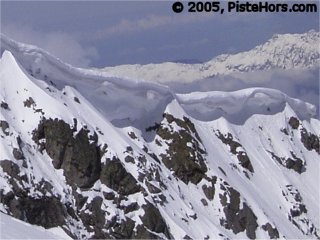
Cornices on east slopes
With the recent freeze-thaw cycle the snowpack is fairly stable earlier in the day with the risk of slides increasing as the snow is warmed. There are still a number of cornices, particularly overhanging east facing slopes and some slabs which could be triggered by a group of skiers, snowboarders or snowshoers.
Pyrénées
The weather continues to be quite warm in the Pyrénées with temperatures only touching zero at 2000 meters overnight and rising to 3000 meters during the course of the day. There has been up to 15cm of fresh snow over the week, although this has fallen as rain in some areas and altitudes. There are spring snow conditions and continuous snow cover starts from around 1500 on North facing slopes.
After two weeks of thaw snow depths are normal for the season except in the central Pyrénées where they are above average but ridgelines, cols and summits are frequently snow free due to strong winds over the winter. Snow is expected in the west above 2000 meters during Friday night with temperatures turning colder during Saturday, elsewhere a clear night and good overnight refreeze are expected. The snowpack will humidify rapidly during the course of Saturday due to the warm rapidly strengthening south to south-west wind.
The snowpack is now fairly stable. The recent high temperatures have purged most slopes and couloirs. Some sluffs are expected during the course of Saturday where there has been new snow (attention these can cause an accident where the skier is above cliffs) with larger slides, cornice collapses and some slabs at altitude on North and East slopes also possible.
References
This information is a summary of current conditions and is provided for information only. It is based on direct observations and information from the following sources.
Météo France issues daily avalanche bulletins for the French Alps, Corsica and Andorra. You should ideally consult at least the previous 5 days bulletins prior to your trip in order to have an idea of recent conditions.
SkiTour conditions database, Camp2Camp and Bivouak have trip reports with observations of the snow conditions.
Weather information is complemented by the USAF Public Weather Charts
Henry’s Avalanche Talk publishes a daily translation of the Météo France bulletin for the Savoie area.
Les Sybelles Tourist office also has an English translation of the Savoie area avalanche bulletin.
Posted by
davidof on Friday, 01 April, 2005 at 10:06 AM
A 30 year old French snowboarder was killed off-piste in the Saulire sector today after falling over cliffs as around 2,500 meters altitude. The accident occured shortly after noon.
Posted by
davidof on Saturday, 02 April, 2005 at 01:00 AM
Page 1 of 1 pages
Comments are now closed