2007-2008 was a comeback year for French ski resorts which posted a record turnover of 1.2 billion euros. More than 20% up on 2007 and even up in real terms on the previous best 2006 season. However with even high altitude resorts like Val Thorens covered by 50% artificial snow cover what was the season like for real skiing?

November snow
As with previous years this review looks at snow on the ground from the viewpoint of off piste skiers and snowboarders including ski tourers.
The season started very early with the first skiable snows falling at mid-altitudes in the French Alps at the end of September. Enough for some hardy, or is that foolish, souls to take out their skis. All French resorts are closed during September so skiers had to climb.
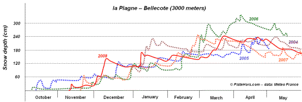
Figure 1: Snow cover at 3000 meters at la Plagne
The snow soon vanished and what followed was a very dry but not too hot October with snow returning in the second week of November. France missed the exceptional cover seen Austria and eastern Switzerland but there was around 40cm at 1500 meters in the Alps. Tignes glacier, which had been open since the start of October, had enough to open runs to the village but in an even bolder move les Sept Laux, a mid altitude resort close to Grenoble, opened its slopes on the 17th of November. An all time record. The resort was mobbed by snow hungry skiers suffering from a year of famine.
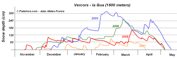
Figure 2: La Gua in the Vercors, typical of mid altitudes
The picture in the Southern Alps was also good with half a meter of snow on the ground from the second half of November. In the first ten days of December this was topped up by further falls of snow so that most of the Alps had over a meter on the ground from mid-altitudes with continuous snow cover from 1000-1200 meters. The valley floors even briefly turned white. Christmas had indeed come early for French skiing with the best early season conditions for a decade.
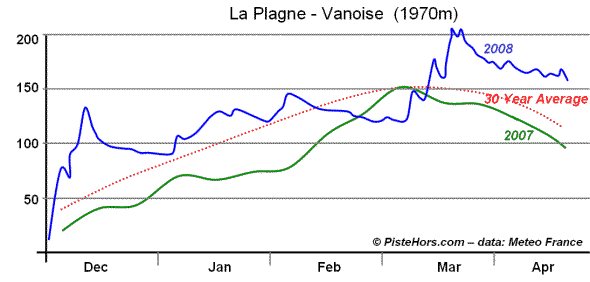
Figure 3: la Plagne, 2000 meters
Weather over Christmas and New Year was stable and mild with an anticyclone blocking the situation. The Northern Alps had to wait until early January for significant fresh snow. The weather that followed was pretty much exceptional. Another stubborn anticyclone installed itself and there followed two months of almost uninterrupted sunshine and stable spring snow conditions. What fronts did make it through this Maginot line were very weak. This was reflected in the avalanche fatalities with not a single fatality recorded over a two month period starting in mid January.

A cold and snowy December
The Southern Alps saw better conditions with regular snowfall during January culminating in their biggest snowfall of the winter at the start of February.
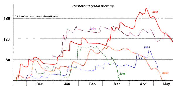
Figure 4: Snowfall in the Southern Alps
Thanks to the early January top up resorts had a stock of over 1m50 of snow at the top of their domains. The long and clear cold nights preserved this snow and the lack of rain at altitude also helped the situation. Above 2000 meters the cover was average to above average. At 1500 meters the situation began to approach that of the disastrous 2007 season by the second half of February. Not bad on ski runs as snow making could be operated during the cold nights but practically unskiable elsewhere where there was tree cover or rocky terrain. At low altitudes the conditions were poor with most of the ski resorts closed in the Vosges. The Jura and Massif Central, with a bit more altitude faired somewhat better.
Precipitation was significantly below average in the Auvergne, Pyrenees and the Maritime Alps. In summary the period from January to March saw good to average snow cover above 1800 meters in the Alps. Very good snow cover in the Southern Alps and very poor snow cover in the Pyrenees. There was no significant snow at valley level during the whole season.
Looking at temperatures. December was a relatively cold 0.7C below average. January 2.3C above average and February 1.9C above average. Both months nearly as warm as the sweltering winter of 2007. Temperatures were +23C in the south east of France on the 28th of January (a record). Overall winter was 1.1C warmer than the long term average putting it into the 10 hottest winters since records began in France in 1900.
Winter finally returned in mid-March. Low temperatures with successive snowfall in the Alps and Pyrenees so that by mid-April the snowcover was above average on all mountain ranges.

A return to winter in March in the Chartreuse
Spring was relatively mild, very wet with little sunshine. Temperatures were average in March, slightly above average in Aprl and +2C above the long term average in May. May was the 4th hottest on record since 1900. Overall Spring was +0.8C above average and the wettest since 2001.
The start of May was cold and dry but the rest of the month warm with rain at altitude. In the Northern Alps the zero isotherm spent much of the month between 2500-3000 meters with some days closer to 4000m. Ski touring was almost a virtual washout in the region from mid May to early June. The start of June and middle of the month were colder, the zero isotherm briefly dropping below 2000m. There was still snow cover from 2000 meters on flatter north facing slopes but the snow was very uneven with rain channels and sun cups below 2400m. Above 3000m there was still considerable snow fall but this lead to an increase in avalanches. From mid March there were 13 avalanche fatalities, over 60% of the total. An indicator of the amount of snow fall and unstable conditions.
Regular snowfall from the start of December to mid January meant good conditions in Corsica. There followed a long period of warm dry weather reduced snow cover to below average. In March there was significant snowfall on the 7th of March and 20th March with cold weather with up to 120cm of new snow. Snow cover was once again above average. Despite a return to spring in April conditions were still above average at altitude with around 2 meters of snow at 2400 meters.
Autumn was dry with first snow at the start of December. The Pyrenees often benefits from early snow generated by weather systems over the Mediterranean so the late snow was unusual. By mid December there was a good base of 50cm. The snow was affected by rain at altitude during the first couple of weeks of January. Cover was below average and things only got worse as the area entered the main school holiday period at the start of February with warm dry weather to mid February and rainfall at altitude until the start of March. There was almost no real snow below 2000 meters and the poorest snow for the last 12 years higher up. As figure 5 shows the situation was hadly better than 2007 until March.
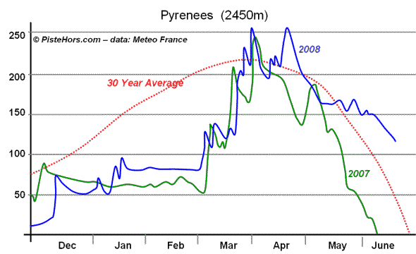
Figure 5: Pyrenees at 2450 meters
Winter only really began in the second half of March with regular snow cover returning the situation to above average over 2000 meters by April. The end of season was well excellent, although most ski resorts were closed, with the touring season lasting well into June, a fortnight longer than normal. However the end of season snow was marred by three avalanche deaths.
The first snow came in mid November with 30cm from 800 meters. Enough for ski tourers to attempt the summits of Le Reculet from the Geneva hinterland. There was continous snow cover above 700m from December. Warm weather in January and February meant the skiable snow retreated to around 1100-1200 meters. At the start of March there was 30cm of snow down to valley level and it was again possible to ski to 800-1000m on prairies. The start of spring saw the biggest snow falls of the winter with 40cm of fresh snow on the Geneva hinterland at 600m, 50cm on the Col du Sion separating Geneva from Annecy and 70cm on the Saleve and Reculet. There was still snow on the ground at 900 m at the start of April with skiers touring into the first half of the month.

Spring snow in the Jura in January
Snow cover was varied greatly between south and north facing slopes. South facing slopes below 1100 m had no snow cover from January to February. On northern slopes there was significant cover above 1200 meters.
By mid December the Vosges had a base of 50cm of snow above 1000 meters. The warm January weather lead to a rapid thaw and from the middle of the month to mid March snow could only be found on the summits. The start of spring saw fresh snow with 1 meter on the ground at altitude. Too late for the area’s ski resorts which had a torrid winter.
Le Mont Dore had its earliest snowfall since 1959 at the end of September but the real snow cover began in the second week of December with 20-40cm on the ground. As in the Pyrenees January saw a mid of rain and snow so that by the end of the month there was little cover below 1300 meters. It was only from March to mid April that there was any real cover at this altitude (about half a meter).
In the Massif Central there was a total of 3m of snow fall between November to April at 1250 but half that fell in March with continuous snow cover really only present on peaks.
In conclusion there was a good early start to the season. Skiers then enjoyed spring conditions and stable snow on south sector slopes throughout the winter months. Powder was harder but not impossible to score but you had to look on sheltered north facing slopes. The snow conditions were relatively stable although the early snow fell on warm ground and this would lead to a number of large full depth avalanches during the season.

Heavy February powder
Real winter began in mid March with good skiing through to mid May. Unsettled weather to mid June left few good spring touring days and dangerous conditions at altitude. Conditions from mid-June in the Alps were exceptional above 3000 meters with routes such as the Nant Blanc on Mont Blanc being repeated (only the second ski descent in 20 years).

Figure 6: Snow in the Prealps
During the winter skiing below 1500 meters was very limited with conditions only returning to average above 1500-1800 meters. The situation improved greatly above 2000 meters. Figure 6 shows the situation in low mountain areas such as the Jura, Chartreuse and Vercors. The summits had good snow cover in 2008 following an extremely poor 2007. However at the trailheads, typically between 800 and 1100 meters there were long periods during the winter where a hike would have been required in order to find snow.
The Southern Alps probably had the best overall conditions. The season started in November with excellent snow depths from the mid March. The downside were five avalanche deaths, three of them in the Alpes de Haute-Provence in separate incidents. Skiers were still touring to the end of June in the Mercantour, just one hour from the beach at Nice. The Pyrenees also had excellent end of season conditions with a corresponding in avalanche deaths.
Ski resorts, particularly high altitude ones with good snow making were happy. The mild sunny weather had been excellent for reservations during the all important February winter holiday period. Poor conditions at lower altitudes forced skiers back into the clutches of the mega domains where their wallets could be well and truly emptied. Mid altitude resorts had excellent end of season conditions but a lack of visitors. Many resorts that had been scheduled to close at the end of March continued to the second half of April but although conditions were the best of the season, slopes remained disappointingly empty.
Graphs in large format: http://picasaweb.google.co.uk/david.george/SnowConditionsFrance2008
Retrospective on the 2003 2004 ski season
Retrospective on the 2004 2005 ski season
Retrospective on the 2005 2006 ski season
Retrospective on the 2006 2007 ski season
Snow and Avalanche conditions