Snow and Avalanche Report: Week 6-2005
After a long spell of dry and reasonably cold conditions rain and snow will move down from the North into the mountains of the Jura, Massif Central, Northern Alpes, Corsica and Western Pyrénées over the course of today. Around 15cm of fresh snow is estimated for the Savoie and Haute-Savoie at 2000 meters, 20cm in the Pre-Alps. This fresh snow is falling on a surface that has a freeze-thaw crust on Southern slopes and on powder on Northern slopes. The prolonged cold weather has formed a layer of surface hoar and facetted snow on colder aspects. Nice to ski, this is a weak layer when buried.
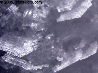
surface facets yesterday - a weak layer when buried
The avalanche risk will increase over the course of today and the weekend as these layers are buried by the fresh snow and larger, more cohesive, accumulations form under the influence of a strong wind from the West to North-West. There is still no respite for the Southern Alps which are suffering from a lack of snow. The precipitation is expected to continue over the weekend until Monday when snow at valley levels is predicted.
Northern Alps
Snow conditions in the Northern Alps are still good at low and mid-altitudes but there is a lack of snow around 2500 meters. Ski touring last weekend we were surprised to climb out of relatively good snow at the tree line into a landscape punctuated by a lot of rocks. The calm, sunny weather has stabilized lower South to South-West facing slopes with a freeze/thaw cycle – there were almost spring snow conditions but lots of breakable crust elsewhere where the sun had an effect. Powder could be found on shaded aspects. Yesterday in the Belledonne the conditions could be quite variable, ranging from easy to ski powder to ski grabbing crust over a few meters. The precipitation today will be accompanied by warmer temperatures; the zero isotherm will climb to 1800-2000 meters during the day, warmer towards the south. So not much snow below 1700 meters.
As well as forming new accumulations and slabs the fresh snow will also have the effect of overloading some old slabs that remain on colder slopes from the end of January. A small avalanche may also have the effect of triggering one of these slabs. A walker was caught by a large slab avalanche in the Chablais last Friday and on Sunday two off-piste skiers were killed by a big avalanche in the la Plagne sector; other large avalanches have been observed.
Great care should be taken in route selection when going off-piste over the weekend, particularly when the weather brightens on Sunday. The large slabs are fairly strong so safe travel procedures – particularly group spacing when climbing and descending suspect slopes. These routes include those that have not been stabilized by frequent skiing, convex slopes and slopes punctuated by rock outcrops. The expected rain below 1700 meters should stabilize those slopes when the weather turns colder on Monday but may cause some full depth avalanches first as the snow becomes overloaded and water penetrates to ground level.
Southern]http://pistehors.com/backcountry/wiki/Ski-Areas/Southern-Alps]Southern Alps[/url]
The snow cover is poor to very poor with lots of bare rocks at altitude due to the effect of the strong winds over the course of the winter. In sheltered areas there is a layer of powder like facetted snow, at altitude the surface is wind packed except on South facing slopes where spring snow conditions can be found. Despite the overcast conditions just a few flakes of snow are expected in areas to the north. The zero isotherm will climb to 2400 to 2800 meters over the course of the day with a strong wind from the North-West in the north.
There is a localised risk of slab avalanches above 2000 meters in North-East to North-West facing slopes where there are large enough accumulations of snow.
Corsica
Some snow is expected in the west above 2200 to 2400 meters with a strong wind from the West. The snow cover is slightly above average and the mountains are white from 1000 meters with 50-75cm at 1500 meters altitude. There was fresh snow at the start of the week, 25cm in the east of the Renoso range, this is now covered by a skiable crust except on very sheltered slopes. This snow was accompanied by strong winds from the east and has formed large cornices and windslabs on West facing slopes. There is also a risk of slabs on South slopes from previous snow fall. These slabs are often covered by fresh snow and hard to detect. There is also the risk of natural avalanches in the east which will be warm and sunny today.
Pyrénées
Warm, rainy weather is moving into to the Pyrénées with the zero isotherm rising to 2500 meters in the east, 2800 meters in the west by this evening accompanied by a moderate to strong wind at altitude. The snow cover is excellent in the West and Central areas at low and medium altitude but average at altitude. The east of the range saw heavy snowfall, up to 80cm, at the start of the week, with a risk of powder avalanches in the Canigou range.
Powder can still be found in sheltered north facing bowls but there is a breakable crust present on other aspects. On cols and ridgeline the snow is usually wind packed.
The snow pack has barely begun to stabilize after a long period of cold. The warmer weather over the weekend should lead to a good freeze/thaw cycle with natural avalanche activity increasing during the day. There are some large local accumulations of snow in sectors sheltered from the wind; these are often lying on older weak layers where it is possible for a single backcountry traveler to trigger a slab. The risk is higher in the east of the mountains.
References
This information is a summary of current conditions and is provided for information only. It is based on direct observations and information from the following sources.
Météo France issues daily avalanche bulletins for the French Alps, Corsica and Andorra. You should ideally consult at least the previous 5 days bulletins prior to your trip in order to have an idea of recent conditions.
recorded in Camp2Camp and Bivouac have trip reports with observations of the snow conditions.
Weather information is complemented by the USAF Public Weather Charts
Henry’s Avalanche Talk publishes a daily translation of the Météo France bulletin for the Savoie area.
Posted by
davidof on Friday, 11 February, 2005 at 10:58 AM
There was a large search operation at les Deux Alpes yesterday when an off-piste skier triggered an avalanche that reached the Piste du Diable at around 11am. The skier thought he saw a skier caught in the slide below.
The two hour operation to probe the slide involved around 80 pisteurs and members of the CRS des Alpes. A helicopter with a medical team was also on standby.
The avalanche risk was 4 on a scale of 5 in the resort and chequered black and yellow flags were flying.
Posted by
davidof on Monday, 14 February, 2005 at 09:29 PM
Page 1 of 1 pages
Comments are now closed