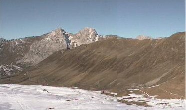
Isola looks very good for the time of year with over 50% of the domain open. So it is not doom and gloom everywhere.
Posted by davidof on Sunday, 12 December, 2004 at 03:58 PM
Page 1 of 1 pages
A low pressure system is currently sitting in the Mediteranean sea of the Italian coast. This brought snow and rain to the Pyrenees, Southern French and Italian Alps and diluvian.conditions to Corsica where 150mm of water fell on the Rotondo and 260mm on Renoso but this only fell as snow above 2200-2400 meters.
Over the next 24 hours the low will be forced south-west and a high pressure over France and Eastern Europe will dominate bringing clear, sunny conditions for the next 5 days. Little significant snowfall is forecast before the 20th.. Not exactly good news.
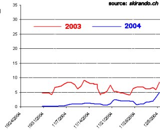
Comparison ski outings 2003/2004
The graph shows ski touring outings logged by the skirando.ch database for the Northern Alps plotted as a 7 day moving average and illustrates the current poor start to the season. Despite an early start 2003 wasn’t brilliant by any means.
The situation remains pretty desperate in the Haute Savoie with the mountains looking very brown, particularly on south and west slopes where the snow only begins around 2,500 meters. On northern slopes things look more wintry but snow depths remain poor below 2000 meters except in resorts where there is snowmaking. It is possible to ski to around 1600 meters, for example in sheltered north-west couloirs in the Aravis range. The automatic monitoring station at 2380 on the Aiguilles Rouges in the Mont-Blanc records no snow with positive temperatures. The last significant snowfall was 20cm on the 18th of November. Basically little snow, little risk of avalanche although the old snow will present a sliding surface after the next snowfall. Higher up the snow has been largely stabilized by the warm fohn (south) wind.
In the Savoie the situation is similar apart from close to the border with Italy in the Vanoise and Maurienne. A weather front during Wednesday night brought rain below 2800 meters accompanied by strong east winds which affected training for the Men’s Ski World Cup at Val d’Isère. Higher up there was about 10cm of fresh snow. The snow is very humid to the east of the region with a freeze crust off-piste. Ski tourists in the Vanoise report no base below 2000 meters although it was possible to descend to around 1400 meters last weekend on certain north facing slopes that were sheltered from sun and wind. The snowpack is quite varied at the moment with some unstable layers. The recent moderate to strong winds from the south and east may have formed some fresh slabs, principally at altitude close to the Italian border on North and West slopes.
In the Isère good snow cover can only be found from around 2,600 meters. Last weekend ski mountaineers were able to descend to around 1900 meters in the Ecrins. Of the 110cm of snow recorded at the start of the month at the Ecrins – la Grave automatique monitoring station only some 60cm remains. A strong south wind has humidified the snow pack below 2200 meters and this has speeded up the thaw. The avalanche risk is similar to the Savoie.
With the 0C isotherm between 2600 to 3000 meters over the next few days conditions will not improve.
Lyon Neiges is opening their old dry slope over this weekend. They’ve imported 4,200 meters cubed of snow from the Maurienne, although we can’t think where they have found it all. Val Thorens instructors Thomas and Antoin Diet will be there today demonstrating some urban freestyle which should be fun.
Flaine should have been opening its ski domain this weekend but say that the warm temperatures have stopped them making sufficient artificial snow. A small area will still open. l’Alpe-d’Huez is also due to inaugurate the Marmottes 3 lift which will give access to the Sarenne Glacier.
Southern]http://pistehors.com/backcountry/wiki/Ski-Areas/Southern-Alps]Southern Alps[/url]
There was 5 to 10cm of fresh snow on Wednesday night above 2000 meters in the east of the region with considerable snowfall on the Italian side of the border. There is a base from 2400 to 3000 meters depending on the slope although conditions are rockier further to the south. The south to east, winds and warm weather have led to a thaw at lower altitudes and have humidified the snow pack further up. This will process will continue over the coming days. The wind has also blown some snow around and there are some fragile slabs on North-East to North-West exposures at altitude.
After Wednesday nights weather front the conditions are better than average 0for the season above 2200 meters. The recent heavy snow was accompanied by strong winds and there are important accumulations of snow at altitude on summits and ridgelines on all slopes.
Despite milder, stable weather risk of triggering a slab will remain significant over the next week.
There is around 1 meter of snow at 2,400 meters altitude in the Rotondo massive. The heavy rain at lower altitudes has washed away most of the snow.
To the west the snow conditions are patchy but about average for the time of year. Off piste the surface is crusty due to the action of rain or wind, on southern aspects the snow humidifies rapidly during the day but on shaded slopes there is still instability present in the snow pack and care should be taken on steeper slopes (30 degrees +) There is about 25cm of snow at the automatic monitoring station of Soum Couy at 2150 meters and closer to 70cm at the lac d’Ardiden at 2450 and nearly a meter at Maupas at the same altitude. It is possible to ski to around 1600 meters depending on slope aspect.
The weather front that brought torrential rain to Corsica largely bypassed the western Pyrénées with perhaps about 10cm to 20 cm of fresh snow in central areas at 2,500 meters but closer to 40cm to 60cm in the east of the Ariège. Further to the east the situation has improved considerably with up to 70cm of fresh snow. There is now over 80cm of snow on the ground at Canigou at 2140 meters. This fresh snow is quite humid below 2200 meters and sitting on a freeze-thaw crust in places. Snow sluffs are to be expected on sunny aspects with the rise in temperature.
Météo France issues daily avalanche bulletins for France. You should ideally consult at least the previous 5 days bulletins prior to your trip.
Henry’s Avalanche Talk publishes a daily translation of the Météo France bulletin for the Savoie area.
Isola looks very good for the time of year with over 50% of the domain open. So it is not doom and gloom everywhere.