Snow and Avalanche Report: Week 4-2005
As everyone will no doubt know, the week’s excellent snow conditions were marred by a series of avalanche accidents, starting on Saturday with the death of a snowboarder in the resort of Les Karellis in the Maurienne valley. Yesterday afternoon a father and son were caught with tragic consequences, taking a shortcut between the pistes in the resort of Le Tourmalet. A reminder that it is not just hard-core extreme skiers who are at risk.
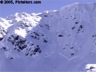
Slab Avalanche at the base of cliffs
There were also a number of non-fatal but still serious incidents which didn’t make the headlines. This phenonoma is well known to avalanche professionals and is referred to as the “first Sunny day” effect. During the bad weather the dangers are obvious to most but looking over the mountains in their coat of fresh snow it is hard to imagine the dangers that lie below. This week it was not just tourists that were caught out but locals and snow professionals.
The first thing to note is that the majority of victims were wearing avalanche beacons. Depth of burial, delay in rescue due to riding alone and injuries sustained during the slide were all factors and a reminder that carrying a beacon does not make you invulnerable to avalanches. As we noted on our report on last year’s backcountry accidents currently the Avalanche Airbag System (ABS) is the only safety device beyond a transceiver with a proven record of reducing deaths. The wearer pulls a rip cord which inflates two balloons with 150 litres of gas. This keeps the wearer on the surface of the slide. Usually providing a visual clue to location, faster recovery and preventing crushing injuries and hypothermia due to depth of burial. Piste security and guides in many resorts are beginning to use the ABS.
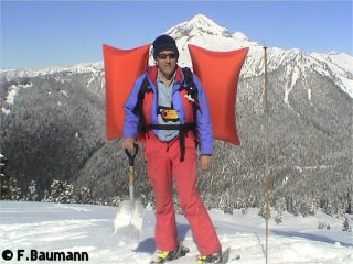
Frank Baumann demonstrates the Avalanche Airbag
A relatively heavy (1.5kg) and expensive piece of kit (prices start at 350 euros) it is by no means certain that the ABS would have changed the outcome of any of this week’s fatalities. The second Val d’Isère avalanche victim, Raphael Potin, was found very close to the surface of the avalanche and delay in rescue was surely a factor. In a couple of the other incidents we understand that injuries sustained during the slide were significant, something the ABS will not prevent. You don’t need a big dramatic avalanche to be injured or killed. A couple of years ago a slab avalanche about the size of a double bed was enough to knock one skier of his feet in a couloir and carry him several hundred meters – he suffered a broken thighbone and many months recuperation. A small slide can also bury the skier under many meters of snow where there is a terrain trap, such as a stream, frozen lake or hollow.
So what were the conditions that lead to this week’s dramatic avalanches? After a long period of stable and sunny weather, conditions that stabilized slopes at lower altitudes and on Southern aspects, winter returned with a vengeance. Some warm weather last Friday brought rain to around 1800 meters, a little higher in the Pyrénées. Over the weekend some resorts in the Savoie and Haute Savoie recorded over a meter of new snow. There was also significant snow in the pre-alps, in the Chartreuse on Wednesday we found around 60cm of fresh snow at 1500 meters. This was accompanied by some strong winds. This has overloaded the snow pack on any colder slopes, that is North through to South-West and East at this latitude in January. These slopes are currently composed of a number of layers, in particularly a significant layer of depth hoar (facetted snow) at ground level. This very weak layer is formed by strong temperature gradients in the snow pack, around 10 degrees Celsius per meter. Yesterday in the Belledonne we recorded 140 cm of snow depth at 2270 meters altitude with a surface temperature of -23C and a ground level temperature of -2C, ideal conditions for growing this weak layer. Where the snow pack is thin or heavily loaded an avalanche can break to this layer.
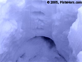
Depth hoar forms a weak layer
Other layers in the snow such as sun or wind crusts and the surface at night time can also exhibit very strong temperature gradients and form local layers of facetted snow. Where the surface snow shows some cohesion (a slab) the weight of fresh snow coupled by a single skier can be enough to trigger a slide. Some of the avalanches this week were very large, 80cm thick. In the Sept Laux ski resort the Piste Patrol had triggered slabs of around this depth using explosive.
The wind serves a role, wind speeds above 20km/h can transport snow leading to significant accumulations, it also breaks down the delicate crystal structure of snowflakes and snow can accumulate in hard slabs. Contrary to urban legend these are not always easy to detect, this week many hard slabs have been covered by fresh snow and are invisible. The danger doesn’t just lie close to summits or ridgelines on lee slopes. The quantity of snow this week can form soft slabs on all aspects and altitudes.
Contrary to popular myth, the current artic weather conditions will not stabilize the snow, this idea probably comes from looking at the freezer compartment of a fridge where everything is frozen solid. Instead it acts to preserve existing unstable conditions with the exception of where it rained last Friday. Initially the rain will penetrate the snow, in some cases leading to wet snow avalanches as it breaks the bonds between snowflakes or penetrates to a surface layer of grass. However the cold weather will freeze this water, bonding the snow. However remember that there has been considerable fresh snow since Friday.
Northern Alps
The last few days have been extremely cold, we recorded -9C at midday in the Belledonne mountains at 1350 meters and -13C at 2270 meters. A sea of clouds brough a few cms of fresh snow at mid-altitudes. The sky is covered by a layer of thin cloud today but no more than a few flakes are expected. Temperatures will be similar to yesterday with a moderate wind at 2000 meters from the North-East, stronger at altitude and veering to the North.
Snow conditions are obviously good. There was some 50cm of snow at 1300 meters yesterday and the cover extends below 1000 meters. There is powder snow with large accumulations on sheltered slopes but ridgelines are almost bare or have wind packed snow due to the strong winds of the last few days.
There is still a strong risk of avalanches on various slopes where snow has accumulated due to the wind from the North, particularly above 1700 meters. Remember that in the mountains the terrain can funnel the wind leading to cross-loading on various aspects. Some of these slabs are very hard and will require considerable force, the passage of a group of skiers, to break. A reminder that group spacing and safe travel procedures of one skier at a time on suspect slopes.
Over the weekend there should be little natural avalanche activity except on steep, north facing slopes and a slight stabilization of the snow pack. Please check with the piste security, guides and the Météo France website before going off-piste.
Southern]http://pistehors.com/backcountry/wiki/Ski-Areas/Southern-Alps]Southern Alps[/url]
It is very cold in the Southern Alps but not much of the recent fresh snow that caused problems in the Savoie made it south. The snow cover is below average. However the strong wind from the North-West to North-East has transported more snow. In particular there are some large accumulations above 2000 meters, often on an unstable layer. There is a danger of slab avalanches even some distance from ridgelines. Particular attention should be paid in regions close to the Isère and Savoie where there was more snow. For example the couloirs in la Grave or Serre Chevalier. The automatic monitoring station at la Grave recorded 40cm of fresh snow last weekend.
Corsica
This week saw the rare spectacle of snow in Ajaccio on the Corsican coast. A number of other islands in the region also had snow on the beach. It is still very cold with the zero isotherm around sea level and snow to 500 meters. There is a meter of snow at 1500 meters altitude, above average for the time of year. A further 10cm of fresh has fallen over the last 24 hours. The snow has been accompanined by strong winds from the North-East.
There is between 70 to 100cm of fresh snow over the last 5 days with a risk of natural avalanches and slabs. In some places hard slabs have been covered by fresh snow and are therefore hard to spot. The snowpack is unstable in places and the slabs could be triggered by the passage of a single backcountry traveller.
Pyrénées
As yesterday’s avalanche at Le Tourmalet has show the avalanche risk off, and even adjacent to, open ski pistes is very strong. Last weeks rain to 2200 meters followed by cold weather has stabilized the snow pack to some extent at lower altitudes. There has been between 50 to 100cm of fresh snow, particularly in the west of the range away from the frontier with Spain. Where there is considerable new snow there is a risk of large full depth avalanches. The strong, gusty wind from the North has transported a lot of snow. There is a risk of soft slab avalanches on all aspects, particularly above 2200 meters. These may be triggered by the passage of a single skier.
A bit of fresh snow is expected today with the zero isotherm climbing to 900 meters. Conditions are currently excellent with dry, light powder on all aspects. There is 90 to 130cm snow depth at 1500 meters and over 200cm in places at 2000 meters altitude. The continued strong wind from the North will create further accumulations of snow over today and a lot of natural avalanche activity is expected.
References
This information is a summary of current conditions and is provided for information only. Météo France issues daily avalanche bulletins for the French Alps, Corsica and Andorra. You should ideally consult at least the previous 5 days bulletins prior to your trip in order to have an idea of recent conditions.
Information for this report comes direct observations and from the trip reports recorded in Camp2Camp and Bivouac
Weather information is complemented by the USAF Public Weather Charts
Henry’s Avalanche Talk publishes a daily translation of the Météo France bulletin for the Savoie area.
Posted by
davidof on Friday, 28 January, 2005 at 12:41 PM
David,
We took delivery of some new 30ltr ABS backpacks this winter and they no longer use a pull cord to activate them. Now there is a small gas cartridge in the handle itself which blows air down a tube and the air in turn somehow punctures the seal on the main can of gas causing the bags to inflate.
I have no idea why they have gone down this complicated route, since after an inflation/test you have to buy not just a new gas bottle but also a new handle!
Also I note that the packs here in Canada/N America come with only one gas bottle & handle and the system is not warented working until the purchaser has tested it and returned a warenty card confirming the test went ok.
Then you need to buy a new handle and gas bottle in order to use it!!
A very strange set of hurdles to cross but I guess liability issues out here have made the ‘test’ neccessary, although why they can’t put 2 handles and bottles in the sale price I don’t know.
Aloha from ‘rain central’ Whistler, BC, where we have fine skiing above the tree line, but ‘cows grazing on the lower slopes’ as the SCGB used to report. At least in our case it is bears, not cows, seeing a bear under your feet as you ride the chair is one of life’s greater pleasures!
Posted by on Wednesday, 02 February, 2005 at 01:03 AM
Page 1 of 1 pages
Comments are now closed