The French mountains are currently dominated by anti-cyclonic conditions which will persist over the weekend with clear, warm and sunny weather. Generally ski conditions are good, particularly at mid-altitudes although skiers will find some crusty snow off-piste. The warm daytime conditions have helped to stabilize the snowpack, particularly on warmer slopes. Backcountry travellers should take care on slopes exposed to the sun during the mid to latter parts of the day and on shaded slopes where there is sometimes a thin, weak layer of snow sitting on an unstable base.
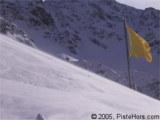
Blown snow on the Belledonne on Thursday
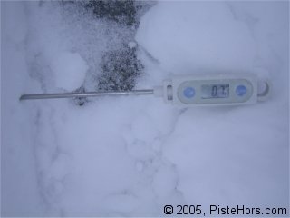
The following two photos are from a snowpit in the Belledonne, on an east facing slope at 2200 meters from last weekend. The thermometer close to the ground shows a temeperature of 0.7C. The fine, sugar like crystals are dept hoar (gobelet) which is a weak layer formed by temperature gradients in the snowpack. The surface temeparature of the snow was -9C. Moisture moves from high to low temperatures through the snow changing the snow crystals to angular grains (facetted snow).
Ground temperatures remain close to zero
In the second picture the 30cm of fresh snow from early last week is clearly visible. It is sitting on a thin ice crust which could form a sliding surface or lead to the formation of angular snow crystals due to temperature differences across this layer.
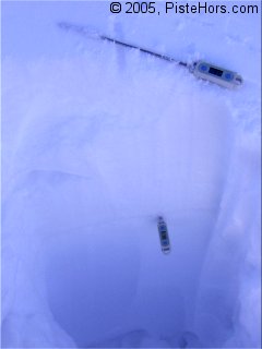
Snowpit from last weekend
The weather in the Northern Alps is clear, warm and sunny with the zero isotherm ranging from 1500-3300 meters at the warmest part of the day. (currently above 2200 meters in the Chartreuse at 1pm). It was somewhat warmer overnight in the north of the region. There is still a strong wind at altitude from the north-west which, as the photo shows, is moving some snow around. The week saw a small amount of snow on Sunday and further snow on Thursday morning above 1500 meters, the total new snowfall was between 5 to 15cm with a rain-crust at lower elevations. Over last weekend there was a strong wind from the east and north which will have moved some snow around.
The snowpack on south aspects and mid-mountain areas will have been more or less consolidated by the freeze-thaw cycle although the risk on southern slopes will increase during the course of the day as the snow humidified and there is the risk of some full depth slides, beginning on south-east slopes and moving to west facing slopes in the mid-afternoon. Rocks outcrops, which conduct heat into the snowpack, present a danger. Colder north, east and west facing slopes still present a risk of slab avalanches, snow pits we dug in the Belledonne showed the presence of depth hoar and the snow depths, especially on roll-overs and ridgelines where the snowpack is thin mean that this instability is not well bridged in places.
Snow begins at around 600 meters on shaded slopes and it is possible to ski to around 800-1000 meters. There is a sun crust on southern slopes that is now thick enough to support the weight of skiers early in the day. The snow conditions are almost spring like. The snow from the beginning of last week fell largely at mid-mountain elevations and the episodes of strong wind mean that snow depths are irregular at altitude.
Southern]http://pistehors.com/backcountry/wiki/Ski-Areas/Southern-Alps]Southern Alps[/url]
The last snowfall dates from the end of December and snow depths are below average, especially at lower elevations. It is possible to ski to 1200 to 1600 meters depending on the aspect. There is still light snow (sugar snow) in areas sheltered from the wind (bowls, woodland) but elsewhere it is windblown. On south facing slopes there is a breakable sun crust. The main avalanche risk is on shaded slopes (north-east to north-west) and at altitude, particularly close to ridges, where the recent strong wind has formed some large accumulations of snow, particularly on western slopes, which are sitting on base with little cohesion.
Clear and warm weather predominates in the Corsican Mountains with light winds. The last snow dates from the beginning of December and snow conditions area good in the west of the island where it is possible to ski to 1500 meters. The snow is well transformed on slopes exposed to the sun with a crust that can support the weight of a skier in the morning. Some slides are possible on these slopes during the course of the day. There are some slabs close to ridgelines on shaded aspects which are sitting on unstable snow.
The New Year was marked by some strong winds from the north to north-west. There was fresh snow, around 5-15cm except towards the Mediterranean Sea. Fog to 2,500 meters humidified the snow pack after which a period of anti-cyclonic weather has lead to clear, warm and calm conditions and stabilization due to a freeze-thaw cycle. The zero isotherm is around 3400 meters today with temperatures of 10c at the base of ski pistes accompanied by a light wind from the south-west. It is possible to ski from 1200 to 1300 meters on sheltered slopes in the west and central mountains and 1700 meters towards the east. The snow cover is good in the west and excellent in the Haute-Garonne and Ariège. South facing slopes have hard snow in the morning and there is some breakable ice crust in other sectors.
The strong winds have moved a lot of snow around. There are some large accumulations on lee-slopes, even at some distance from ridges. Skiers should take care at altitude, particularly on north and east aspects where a group of skiers, or in rare cases, a single skier could trigger a slab avalanche.
There is the risk of wet snow avalanches on sun-exposed slopes during the course of the day.
References
Météo France issues daily avalanche bulletins for the French Alps, Corsica and Andorra. You should ideally consult at least the previous 5 days bulletins prior to your trip.
Henry’s Avalanche Talk publishes a daily translation of the Météo France bulletin for the Savoie area.