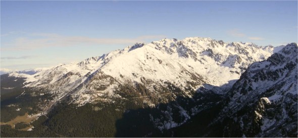
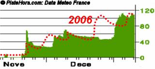
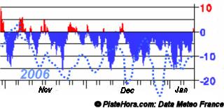
If you are in a high altitude resort you may have noticed something strange covering the slopes this morning. A dusting of fresh snow at 1800 meters. Over the last few days there has been about 20cm of fresh but above the 2500 meters level but below 2000 meters the conditions have worsened from the already poor Christmas weak. The fault, record temperatures and rain.
In Chamonix the overnight minimum has hovered around 5°C with 3 days of light rain in the town. Normal January temperatures for France are around 5°C but since the start of the month the thermometer has recorded 12°C to 15°C with some peaks of 17°C; all this following what Meteo France has called the hottest autumn for 50 years. Some records have been broken, in the wine growing district of Corbiers in the south the temperature was more than 15°C and Toulouse’s Blagnac airport saw 17°C, breaking the previous record for a 9th January set in 1991. In Conqueyras in the Gard a scorching 21.7°C was recorded. Of course it has been hot before in January in 1982, another year with little snow, temperatures hit 19°C and in 1955 21°C.
Is global warming to blame? Yann Giezendanner forecaster for Météo France in Chamonix says that global warming, effectively more energy in the planet’s weather system means more extremese. Both of hot and cold. The exceptionally warm summer and autumn followed a harsh winter. The current mild weather is caused by a West to South-West air stream bringing warm air up from Morroco and looks set to continue for at least another 12 days. However nothing is certain says Giezendanner, the low pressure over Ireland only needs to move 1500km and there will be snow in the Alps. What is sure is that over the last century France has warmed faster than the world as a whole 1°C at sea level and 2°C in the mountains. Meteo France says that February will be colder but overall the winter of 2007 will be above average in temperature with a return to warm weather in March.
The economic impacts are being felt. Due to well placed Christmas holiday most resorts, from the Pyrenees to the Alps, saw occupancy levels around 80%. Good for any year. The cold weather meant that snow canons could be run at resort level. Now it is not even possible to run snowmaking at night. The dry autumn also means that water is in short supply, in the Pyrenees it is the driest for 45 years in some areas. First victim is the Kandahar world cup race at les Houches. This was due to take place on the weekend of the 20th of January but has been moved to high altitude Val d’Isère where conditions are much better. Indeed the warmer 2007 could benefit high-altitude resorts which suffered in the cold of 2006. The Kandahar course was in a sorry state yesterday. A ribbon of soggy snow surrounded by fields. The run even had grass poking through. The resort had considered brining in snow by lorry and helicopter but had no guarantee this wouldn’t melt before the race.
Season workers have also been hit hard. In the Northern and Hautes Alps the snowfall at the start of January meant that most waiting for a job have now been hired but elsewhere things are precarious with many now waiting for the February holidays to start work a full two months later than in a normal year. This means many will not have made sufficient social security payments to draw unemployment benefit during the interseason period.
The Pyrenees have also noted a drop in short stay bookings. January has benefited from low-cost airlines such as EasyJet and Ryanair bringing weekend skiers from Britain out to the mountains but this business has dried up like the winter snows. British skiers are uninterested in the alternative activities offered by the resorts such as mountain biking and hill walking. Ski instructors, guides and hire shops have been particularly hit by the drought of British visitors.
Looking off-piste in the Northern Alps it is still possible to find very soggy snow from 1200-1500 meters on shaded forest tracks with some skiable snow on south facing slopes at 1800 meters. The snowpack is isothermic (0C throughout) below 2000 meters with little overnight refreeze at this level. Rocks are not far from the surface below this altitude. The zero degree isotherm touched 3500 meters in the Northern Alps on Wednesday. There was around 15cm of new snow on the 4th above 2200 meters and a further 5-10cm on the 8th above 2500 meters. Skiing is on a refreeze or wind crust in many places, this softens during the day giving almost spring like snow conditions. There is little powder to be found except at altitude.
The rain has stabilized the snow-pack below 2500 meters with the main risk from wet snow slides as the slopes warm during the day. The Savoie still has some traps. A group set of a slab close to the pistes at Val d’Isère yesterday.
I don’t actually mind a bad winter season without much powder or many epic days. What concerns me more is that there wont be enough winter base to sustain back country touring well into June. Spring is when dreams are achieved: the mountains really open up with windows of stable weather, longer days and the chance to score some couloirs and summits that are out of reach in the freezing cold storms of winter and the accompanying cold fragile snow pack. You could venture out now as though it were spring, but the weather still remains winter-volatile and what’s more, many crevasses are still open or poorly bridged.
Unless Feb delivers a few meters, this spring looks under serious threat. Now that would be really bad. Some of us wait all year for spring to arrive.
I like lamb with yoghurt, but Morocco can keeps its warm winds.
Posted by
Damian on Thursday, 11 January, 2007 at 10:34 AM
I’m worried about the end of season too. The “spring” snow cover at the moment is very thin and Meteo France is predicting a warm spring.
According to Kairn.com
Morroco is suffering from severe cold - must be due to all the heat they are sending north. Apparently it is the longest cold snap they’ve known for a long time with temperatures down to -7,6° the Ifrane “alpine” resort at 1655 meters. Not a record, in february 1935 temperatures reached -24 ºC.
http://www.kairn.com//news.html?ident=50056
Posted by
davidof on Thursday, 11 January, 2007 at 02:11 PM
This interesting page from the CEN (Centre d’Etudes de la Neige) compares current snow cover at various altitudes with the 30 year average (1970-200)
http://www.meteo.fr/temps/scm/wcalpa.htm
The graphs clearly show that in the French Alps, except in parts of the Hautes-Alpes the situation is below average at less than 2400 m altitude. The situation is below average over the whole of the Pyrenees.
The best on piste conditionsa are either in the high altitude resorts such as Tignes or also in the Hautes-Alps such as Montgenvre. In the Massif Central only Superbesse is hanging on and they will close this weekend without new snow. Some of the mid-mountain resorts have also closed. Conditions in Courchevel are not good either.
Posted by
davidof on Thursday, 11 January, 2007 at 02:51 PM
Spare a thought for all the people who haven’t started work yet this winter!!!
Posted by on Thursday, 11 January, 2007 at 04:50 PM
i tried CEN’s webpage and it requires an username and password. do you know another site or even the credentials? it would be really interesting to read that report.
Posted by
engineer on Monday, 17 September, 2007 at 12:47 PM


