This is an archive of the old PisteHors.com forum

News | Gear | Ski Areas | Hiking | Mountain Biking
Powered by Google™
   
 
December 2012 Snow Conditions
Posted: 03 December 2012 11:44 AM  
Sr. Member
RankRankRankRank
Total Posts:  543
Joined  2006-01-24

Some great snowfall yesterday, rather more than forecast and it’s started again now as forecast.

Early morning over the Dents du Midi this morning, some wind blowing the new snow around

20121203-081237.jpg

 Signature 

SwissMountainLeader.com & B&B L’Epicéa, Leysin, Switzerland


Posted: 03 December 2012 05:34 PM   [ # 1 ]  
Member
RankRankRank
Total Posts:  79
Joined  2009-11-09

It’s dumping in Chamonix, 50cm forecast for over night. smile plus it’s windy :(


Posted: 03 December 2012 06:41 PM   [ # 2 ]  
Administrator
RankRankRankRank
Total Posts:  2234
Joined  2003-10-24

A quick look at the snowpack on a ridge at 1800m in the Belledonne range.

http://www.youtube.com/watch?v=UR6HGiYtvnM

we should see some depth hoar formation but nothing in this pit. Only about 30cm of depth here on the ground, probably due to the wind. There was about 50cm in the lee of the ridge.


Posted: 05 December 2012 09:51 AM   [ # 3 ]  
Administrator
RankRankRankRank
Total Posts:  2234
Joined  2003-10-24

Big temperature rise between Monday and Tuesday with 6 hours of the zero iso at 1600m. This was during heavy snow, or rain if you were below 1400m. We piled on about another 30cm of fresh @ 1700m but obviously lower down the nice fresh powder of the weekend will be a bit heavy now. Zero iso is back below 1000m now so that should refreeze the snowpack but not before some purges on steeper ground, indeed Meteo France has warned of a “high” avalanche risk in the Alps and Pyrenees.


Posted: 06 December 2012 09:19 PM   [ # 4 ]  
Administrator
RankRankRankRank
Total Posts:  2234
Joined  2003-10-24

http://youtu.be/UnLk807H9-4

Quick look at the snow conditions on the Pravouta, Chartreuse Range, FR. At 1600 m there was over 130cm of snow. A layer of 50-60cm of fresh snow that has fallen over the last 48 hours. Then a rain crust formed on Monday night when the zero isotherm went to around 1700 meters. They a layer of denser snow. There are no obvious problems with the internal structure of the snowpack at present at this altitude and aspect.

The rain crust was nearer the surface in some areas due to wind scouring. It could cause problems in the future - sliding surface or temperature gradient.

Road conditions. Winter tires advisable above 800 meters today. Essential above 1100 meters on back roads.


Posted: 09 December 2012 11:43 PM   [ # 5 ]  
Administrator
RankRankRankRank
Total Posts:  2234
Joined  2003-10-24

Saturday I was revising my first aid so only saw a few flurries from downtown Grenoble. Today the weather was better, cloud sea with sun at altitude (although not where we were at 1400m). Skiing on piste with the tot, great conditions. Around 40cm of fresh snow on a base off piste at 1000m skiing back to the car.

http://youtu.be/Yqe6MwokZC4


Posted: 12 December 2012 10:36 PM   [ # 6 ]  
Administrator
RankRankRankRank
Total Posts:  2234
Joined  2003-10-24

We have had excellent touring conditions the last few days and the snow is finally going to settle but things are set to change at the end of the week as the foehn blows in. It has been freezing today, never getting above zero but tomorrow we’ll see positive temperatues and on Friday a weather system will bring rain to 2000 meters, hopefully not too much. This may not be a bad thing if we end up with a huge, stable base with fresh snow early next week. We’ll see. Conditions are certainly going to degrade in the short term and expect some mega purges.


Posted: 17 December 2012 05:06 PM   [ # 7 ]  
Newbie
Rank
Total Posts:  12
Joined  2012-12-17

It is raining none stop in the Haute Savoie at the moment at 1200 meters, not looking godo for a white crhistmas.


Posted: 19 December 2012 12:43 AM   [ # 8 ]  
Administrator
RankRankRankRank
Total Posts:  2234
Joined  2003-10-24

Been a little cooler over the last couple of days with snow around 1200-1300 meters. Still predictions of rain to 1600 meters over Friday/Saturday. Not sure the lower snowpack can take much more of this to be honest. On Sunday things were pretty humid in places. I’ve not been out since as the weather has been very damp.


Posted: 20 December 2012 10:50 AM   [ # 9 ]  
Newbie
Rank
Total Posts:  5
Joined  2012-12-17

Looks like a temperature spike for the weekend, not good for the Christmas snow.


Posted: 24 December 2012 02:51 PM   [ # 10 ]  
Administrator
RankRankRankRank
Total Posts:  2234
Joined  2003-10-24

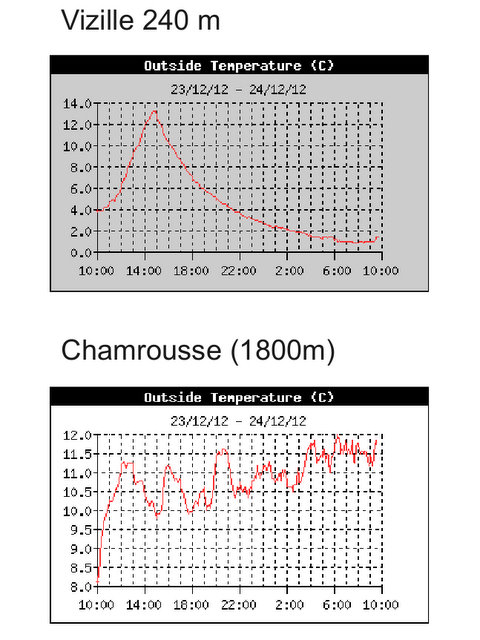
Here is a quick look at the temperature inversion at the moment. 10 to 12C overnight at 1800 meters altitude whereas 1500 meters below in the valley the temperature rapidly sinks down to near freezing.

Screenshot-28.jpg height=640 width=480

Many skiers have been surprised by this. Expecting hard snow and maybe spring conditions in the sunshine they have been confronted with knee deep unskiable mush. The risk of being caught by a full depth avalanche is also not to be ignored, especially ski touring where you are exposed for a long time while climbing.

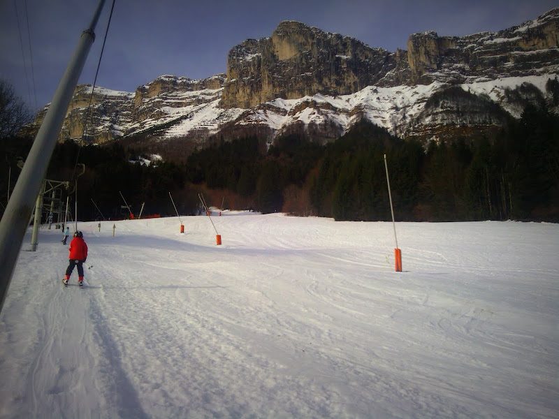
Days for staying on piste, which is what we did yesterday at St Hilaire

IMG_20121223_105605.jpg height=600 width=800

This shot from Friday shows the wind sculpting of the snow

IMG_20121221_111752.jpg height=601 width=800

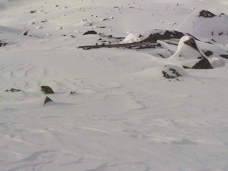
with some considerable cross loading on this slope.

When it cools down conditions should be a lot more stable below 2000-2400 meters. Some fresh snow is expected on Boxing Day (26th) at 900m but it is warming up again on the 27th with the snowline around 1600-1800 meters.


Posted: 24 December 2012 02:58 PM   [ # 11 ]  
Sr. Member
RankRankRankRank
Total Posts:  543
Joined  2006-01-24

It’s a glorious spring day here grin I’d no idea it was so cold in the valley though.

 Signature 

SwissMountainLeader.com & B&B L’Epicéa, Leysin, Switzerland


Posted: 26 December 2012 01:35 PM   [ # 12 ]  
Administrator
RankRankRankRank
Total Posts:  2234
Joined  2003-10-24

We had a lot of rain overnight, according to Meteo France it was supposed to snow from 1000m but around these parts (Isere) it snowed from 1500 meters. Conditions off piste are very soggy below 2000 m. The best best for off piste skiing is to go high and for touring to perhaps use ski runs to gain some altitude.

Rumours are for colder weather around the New Year and a return to some mid level snow.

I’m off to Italy tomorrow until early Jan - not skiing but eating chocolate in Turin.


Posted: 26 December 2012 09:34 PM   [ # 13 ]  
Administrator
RankRankRankRank
Total Posts:  2234
Joined  2003-10-24

Around 30 to 40 cm of fresh snow expected tomorrow (Thursday 27th) accompanied by strong winds from the west. Snowline 1500-1700 meters in the west dropping to below 1000 meters in the east (Haute-Tarentaise, Vanoise...).


Posted: 27 December 2012 04:37 PM   [ # 14 ]  
Administrator
RankRankRankRank
Total Posts:  2234
Joined  2003-10-24

About 5cm of fresh snow at 1000m in the Haute Maurienne this morning. Much less on the Italian side of the mountains.


Posted: 29 December 2012 08:35 PM   [ # 15 ]  
Administrator
RankRankRankRank
Total Posts:  2234
Joined  2003-10-24

Snowpack is slowly stabilizing but take care on N -> E sector slopes especially above 2000 meters. There is a lot of hoar crystals and also graupel about. This will form a weak layer after the next snowfall due Tuesday.

Henry has this video of the rotten snow

http://www.henrysavalanchetalk.com/weak-layer-high-ridges-passes-above-2500-dec-29-2012-n-fr-alps