Thanks for the link, which is also new to me, and is very interesting. It’s a shame there isn’t more detail on just what these sensors are measuring. This post is an attempt to understand this a bit better.
The instruments are better described on the Campbell Scientific website http://www.campbellsci.co.uk/ and the flowcapt site http://www.flowcapt.com/. The “technical notice” on the latter describes the snowdrift sensor.
I ski in the Espace Killy, so I’ll focus on the Tignes sensor http://213.3.18.26/flowcapt/stations/FCHE1/ . This is actually on the east side of the main road (the opposite side to Tignes), so well away from all but the most determined skiers.
Like you, I was puzzled by the light blue “snow height” curve, but I think you are right that there are two sensors and the light blue curve is the exposed sensor. (The dark blue curve is close to the official depth for the altitude.)
To start with I was confused by the configuration shown at http://213.3.18.26/flowcapt/stations/FCHE1/FCHE1_image.html (reached by clicking on “Informations” near the top of the page. This page also gives a map of where the sensor is and a location on Google Earth.) The schematic configuration doesn’t show it as having a snow depth sensor at all. However, the historical data 2005-7 on this page don’t include snow depth data either – the graphs are blank. There is a photograph of “Installation Hneige2 Fev09”. “Hneige2” suggests there should be an “Hneige1” somewhere, and it’s reasonable to guess that it’s on the main sensor. The absence of historical data from it suggests that both these sensors were installed relatively recently (Perhaps February 2009? I can’t imagine someone going up there in February to take a picture!) and that they didn’t update the diagram.
It seems likely that one of the snow depth sensors is on the main sensor near the ridge, where it can measure a wind speed and direction accurately. The photograph shows the other as being below the ridge a bit, I think perhaps near the middle of the plateau to the east of the main sensor. The one near the ridge would be more exposed, and one would expect less snow to accumulate there.
By the way, the beam width of the snow height sensor is about 30 degrees, so if the sensor is mounted 2m above ground it is sampling an area of ground ~ 1m in diameter. So don’t worry about stones rolling under the sensor, as you suggest: if the stone was that big, it would have knocked it over!
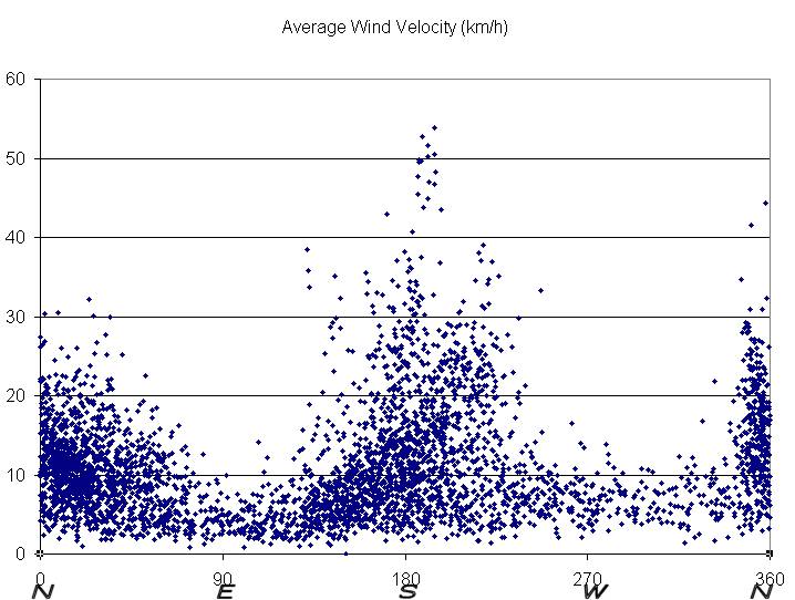
Another thing about the data that struck me was the wind direction. Despite having been skiing in this area for longer than I care to remember, I had not realised how well-defined the prevailing winds are. You can see this by eye on the graphical data, but its more convincing using the excel data they supply (I had to right click on “FCCHE1.xls” and then save it to my hard disk: excel couldn’t open it automatically from the web site for some reason.)
(I wanted to put in a graph here, but couldn’t figure out how to insert a picture.)
Since July this year, the wind at FCCHE1 has only very rarely exceeded 10km/hr from either the east or the west. This is at an altitude of 2869m on a ridge that runs roughly north-south! Strong winds always came from either the north or south, with the south being more common.
Evidently the sensor has been placed with care, and with a knowledge of the prevailing winds. It’s obvious now that I think about it that you have to separate a snow depth sensor (which needs to be sheltered, but not so much that there could be accumulation) and a wind sensor (which needs to be very exposed).
Richard


