Snow and Avalanche Report: Week 15-2005
Conditions are improved after last weekend’s snow with skiing in the Northern Alps down to 1000 meters earlier in the week. Snow levels at altitude are still below average, Meteo France says they are at at 35 year low in some areas such as the eastern Savoie and Ecrins. In the Southern Alps a drought warning is in place in one department with restrictions on water used although the area did see its first big snowfall of the winter on Saturday. The unsettled but warm weather has melted a lot of the fresh snow where there was no base.

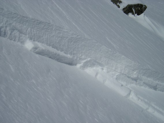
slab avalanche in Couloir NE Reou Arsine
see: [url=http://www.volopress.fr]http://www.volopress.fr[/url]
The snow was also accompanied by strong winds, first from the south-east then the north. These created snow slabs on numerous slopes, particuarly at altitude. A ski tourist was killed by an avalanche in the Aravis mountains despite a rapid intervention by his compagnon and slides involving skiers and snowboarders were also reported at Chamonix, Chamchaude in the Chartreuse, Ecrins and Massif-Central. All fortunately without more serious consequences. Some slabs formed last weekend are still in place.
Northern Alps
Last week saw unsettled but warm weather with a limited freeze/thaw cycle below 2000m earlier in the week. On Thursday night southerly winds strengthened and were accompanied by gusts. Snow levels today are around 1700-2000 meters dropping to around 1000m on Saturday and even lower in the pre-Alps. The heaviest snow will be on Satuday but unsettled conditions will continue into next week. The fresh snow will be accompanied by a strong but moderating south-east wind, this will shift to the east later.
The fresh snow will lead to sluffing and some more significant natural slides on steeper slopes including some northern aspects that have not purged last weekend’s snow. The strong gusty winds will transport snow and will lead to the formation of fresh slabs.
The bottom line is: take care on steeper slopes during and immediately after the new snow fall and give large accumulations of snow time to purge or stabilize. Be aware of more persistent risks at higher altitude close to ridges, cols and summits. With the strong southerly winds you can expect the greatest danger of slabs to be on shaded and sheltered northern slopes but the gusty nature of the winds coupled with terrain factors could lead to slab formation on other slope aspects.
Southern]http://pistehors.com/backcountry/wiki/Ski-Areas/Southern-Alps]Southern Alps[/url]
The conditions have improved after last weekend’s snow; the most important over this winter. This snow is well stabilized except above 2,500 meters on north facing slopes. Around 10-20cm of fresh snow are expected over the next 24 hours particuarly in the Dévoluy and Champsaur areas where some natural slides should be anticipated. The strong southerly winds will also form some new slabs.
Pyrénées
Conditions in the Pyrenees are generally good and it is possible to ski from 1000-1300 meters on north facing slopes although the snow is humid to 1800 meters. Last weekend’s snowfall has had time to stabilize except on northern slopes but rain last night has overloaded the snowpack particuarly on steep and grassy slopes. Temperatures will drop today and there will be llight snow below 1000 m continuing to Saturday. This could lead to some sluffing on steeper slopes, particuarly if there is any sunshine. The fresh snow will also load the snowpack.
References
This information is a summary of current conditions and is provided for information only. It is based on direct observations and information from the following sources.
Météo France issues daily avalanche bulletins for the French Alps, Corsica and Andorra. You should ideally consult at least the previous 5 days bulletins prior to your trip in order to have an idea of recent conditions.
SkiTour conditions database, Camp2Camp and Bivouak have trip reports with observations of the snow conditions.
Weather information is complemented by the USAF Public Weather Charts
Henry’s Avalanche Talk publishes a daily translation of the Météo France bulletin for the Savoie area.
Les Sybelles Tourist office also has an English translation of the Savoie area avalanche bulletin.
Posted by
davidof on Friday, 15 April, 2005 at 02:42 PM
It is snowing quite heavily down to the valley floor in the Isere region today (Saturday) so conditions should be better than expected.
Posted by
davidof on Saturday, 16 April, 2005 at 11:24 AM
A snowboarder was killed on Saturday afternoon after falling over an ice fall in the Grand Montets sector of the Chamonx-Mont-Blanc ski area. The accident occured off-piste shortly before 16h00. The rescue helicopter was not able to reach the scene of the accident due to poor weather conditions.
Posted by
davidof on Sunday, 17 April, 2005 at 01:58 AM
Page 1 of 1 pages
Comments are now closed

