Avalanche Risk Reduction Methods
A few days ago we skied a slope in the Bauges called the dent d’Arclusaz. There had been around 60cm of fresh snow earlier in the week and our route raised some eyebrows.
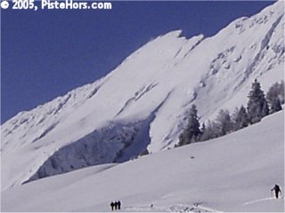
The Dent d’Arclusaz
One person sent this comment:
“I noticed that you toured the east face of the Dent d’Arclusaz last Thursday. Knowing that the angle is more than 40° on this large slope and the risk was around 3 to 4 in the Bauges (I didn’t check the bulletin) I wonder how you decided this outing was safe? I don’t want to criticize anyone but personally wouldn’t feel safe tackling that sort of route with the risks, I would like to know what elements you used to decide if the slope was safe?”
It is an excellent question and highlights the dangers of the Internet. There are many sites and forums where trip reports are published. Just because someone tackled a route does not mean that it was safe or that it will be safe a few hours or days later when conditions may have evolved considerably. Despite the headlines avalanche deaths are relatively rare. Swiss Avalanche Researcher Werner Munter calculated that was 1 death per 50,000 skier days in Switzerland during the 1990s. Apart from the conditions there may be a variety of reasons why one group got away with skiing and slope when another gets caught. Group management, skiing ability etc can all make a big difference. So a big warning, unless you know the professional background of someone making comments on the conditions: guide, avalanche educator etc. be sceptical about what they say. This applies no matter how good a skier or boarder they are.
Back to our question. This is the avalanche bulletin published by Météo France the night before our trip. I’ve extracted the parts relevant to the Bauges and that apply to the slope which, except for the last few meters, is below 2000 meters altitude. It is very important not to make your decision based on just the headline risk, 1 to 5, but to look into the details of the current bulletin. As one guide has remarked, “globablly conditions are good but locally there is a risk of death”. It is also important to have followed the evolution of snow conditions over the season. For example this year the snowpack has been very thin at altitude on many slopes which accelerated the formation of a weak snow layer called depth hoar on northern slopes. Each snowfall has frequently been accompanied by strong winds.
Avalanche Bulletin for the Savoie for the 17/2/2005 (N73160211)
published on 16/2 at 4pm.
Bauges – Considerable Risk – level 3
Zero Isotherm: valleys
-10C Isotherm: around 1800 rising to 2600 m
Wind at 3000 meters: North to East 10 to 60 km/h
Snow conditions
Little natural activity, many slopes sensitive to load
Over the last 24 hours 10 to 15cm of snow had fallen in the Bauges. There has
been between 25 to 65cm of fresh snow over the last week at 1500 to 2000 m.
With the cold this snow will stabilize slowly. Below 2000 to 2200 meters the
accidental risk involves mainly the surface layer. The rising north wind and the
fresh powder could form some new more or less soft surface slabs, largely on
ridges and passes. These could be triggered by a small extra load. A big extra
load could cause a full depth avalanche. Natural activity is not to be ignored
given the wind that can load certain zones, the sun during the day and the slow
settling of the snowpack. This could cause surface or even full depth slides on
steep slopes on all aspects and altitudes.
Whenever you see an avalanche risk of 3 (considerable) you should be thinking about route decisions, timing, weather and the strengths and weaknesses of your group. I noticed a couple of trips over the weekend on a route that has seen several dramas over the years. The participants commented on the whiteout conditions. If there was an accident the rescue operation would be complicated by such conditions. In his book: Extreme Mountain Rescue, Marcel Pérès describes an incident on the Cime de la Jasse in 1997. It took the rescue effort 2 days just to locate the avalanche. Another example, late in the afternoon on the 17th of February, 2005 three snowboarders, trapped in the cliff complexes of the Grandes Rousses had to be rescued on foot when poor weather blocked the Sécurité Civile helicopter in its base close to Grenoble.
So looking at the bulletin the risk could have been reduced by travelling earlier in the day before the slopes are warmed, choosing routes that don’t have too much fresh snow, a shoulder for example, keeping below 2000 meters and taking care close to ridges where slabs may have formed. Group spacing and skiing one at a time would also be a good idea. Our route also has little exposure so a surface slide will have less serious consequences. The run out is also fairly gentle, normally avalanches stop on the slope itself although a full depth slide could still bank up a large depth of snow. The main thing our route does not have in its favour is the steepness.
There are a number of methods for managing avalanche risks, for example: Munter 3x3, Nivotest, Stop Go, Red/Green Light. These take statistical information about avalanches, slope angle, group size, slope aspect etc. and apply them to a particular group, route and conditions in an attempt to give a simple go / no go answer. They are increasingly used by guides and group leaders. Note that the statistical basis of these methods varies depending on the mountain ranges. An obvious example, in the Southern Hemisphere it is South sector slopes that have greater avalanche risk.
One of the easiest methods to apply is Werner Munter’s Reduction Method (Munter is also behind the more detailed 3x3 method). The idea is to take the headline avalanche risk and reduce it to an acceptable level. It relies on detailed sector avalanche bulletins that are available in Europe. In France you really do have to look into the nitty-gritty of the bulletin for your route choice not just take the departmental risk level. Munter believes that his method could half the number of avalanche deaths.
The Reduction Method says:-
Risk = Danger ÷ (RF1 * RF2 * RF3).
The danger is taken from the avalanche bulletin scale. Statistically each increment represents a doubling of the danger starting from 2. The figure for the Bauges is 3, this gives us a danger level of 8. The Reduction Method is not appropriate to avalanche levels 4 and 5.
We now have three classes of reduction factor to mitigate this risk. Only if we can bring the risk level below 1 is the route thought safe enough to risk travel.
First Class, Slope Angle
Steepest Slope Angle is between 35°-39° : 2
Steepest Slope Angle is between 30°-34° : 4
Second Class, Slope Aspect
Route avoids North sector slopes (NW-N-NE) : 2
Route avoids North half sector slopes (WNW-N-ENE) : 3
Route avoids Named Avalanche Slope Sectors : 4
Third Class, Group Factors
Slope stabilized by skiing: 2
Large group with good spacing: 2
Small Group (2 to 4 skiers) : 2
Small Group with good spacing: 3
Our first route choice was the “Pan de Rideau”, however part of slope is more than 39 degrees so there is no reduction. Munter adds a number of special cases. If the risk is considerable at least one first class factor must apply. In this case our initial route is judged too dangerous to ski by this method.
There is a slight variant from the same summit. The steepest section between 35°-39°. The variant is east facing but the bulletin notes the possibility of surface or even full depth slides on steep slopes on all aspects and altitudes. Again there is a special rule, if the avalanche bulletin declares all aspects (or aspects apart from North half sector slopes) as dangerous then no second class reduction factor can be used. This is often the case when the snowpack is wet, when there is a lot of fresh snow or late in the season when there has been no overnight freeze/thaw cycle.
Here we have a grey area, the bulletin doesn’t specify what they mean by a steep slope, they also suggest that this danger is greatest later in the day as slopes warm. Maybe they have snow sluffs in mind? In this case we will apply the reduction factor of 3. Finally the group is small and we will allow good spacing giving us another reduction of 3.
Risk = 8 / 1 x 3 x 3 = 8/9.
A risk of less than one is considered okay to proceed, with caution, but remember what we said about advice on the Web!
Risk Reduction Methods get backcountry travellers to think about route choices and how they can reduce risks by adding more safety factors. Remember that even if Munter’s Reduction Method was universally applied, it would only half the number of avalanche deaths. It is a statistical method which summarizes general wisdom about avalanche accidents but ignores detailed local conditions.
 More information about Munter’s methods for managing avalanche risk can be found in the book Powderguide available from Amazon.com
Posted by
davidof on Saturday, 26 February, 2005 at 11:01 PM
Interesting discussion ! I couldn’t find the complete avalanche bulletin of the day you mentioned. What struck me though is that you apply a reductionfactor of 3 for slope-aspect. But, if I understand well, the avalanche bulletin said ALL SLOPE-ASPECTS were suspected. In this case Munter states explicetly that no reductionfactors for slope-aspect can be applied.
This makes sense, because the reduction for slope-aspect is based upon statistics where some slope-orientations are usually more dangerous than others. However if ALL slope-aspects are dangerous on a given day, these statistics don’t apply anymore.
What do you think? Did I miss something ?
Posted by
Rolf on Saturday, 26 February, 2005 at 03:12 PM
This explains why Hr. Munter has been extremely careful about translations of his work. I’ve updated the article based on your comment and added some more information.
Posted by
davidof on Saturday, 26 February, 2005 at 09:49 PM
Thanks for the ‘heads up’ on Munter’s book, I had never heard of it over here in Canada, but have today ordered a copy from Amazon. It will, I am sure, be a very interesting read.
I’ll be over in Davos CH in April visting my old friend Othmar Buser of the Swiss Avalanche Center, who was the author of the “Nearest Neigbours’ method of statistical forcasting of avalanches. Othmar is now using the same statistical comparison with past years and days to forcast forest fire activity, with, aparently similar success..
Posted by on Saturday, 05 March, 2005 at 03:53 AM
Okay Davidof thanks for your changes. I highly appreciate your efforts for a site like this. Some more considerations about Munter to make it more complicated:
- the steepness of suspected slopes doesn’t have to be clairified in the bulletin: steep slopes are over 30 degrees, very steep slopes are over 35 degrees en extremely steep slopes are over 40 degrees. This is all in Munter (and in other publications as Powderguide)
- Why do you apply second class factor 3 if the bulletin would suggest risk of sluffs (it is unlikely they did by the way) ? If this is due to the effect of the sun these would occur on sunfacing slopes, wouldn’t they? And the sunfacing slopes get most of the second class reductionpoints. So you would in fact give a 3 point bonus to the most suspected slopes for sluffs.
- You say you get no second class reductionpoints if all aspects are suspect (which is right) or for ASPECTS APART FROM NORTH HALF SLOPES. But if only southern half aspects are suspect, you’ll still get 2 reductionpoints for aspects between WNW and NW and between NE and ESE (or E, depending on the bulletin). Note this is different from your second class factors: between NE and ESE 2 points apply (Munter, ed. 2003)
- much of the confusion is due to the formulations of Munter in statements like ‘if you are not skiing slopes in so and so aspects, you get X reductionpoints’. If you give me an Email adres I can send you a handy schedule with reductionpoints that clarifies a lot and is very easy to work with.
- I am afraid your Pan de Rideau route is not a good example for demonstrating Munter’s formula. You simply don’t have any right to the 3 second class reductionpoints (I would still say 1 point, so no reduction, but 2 at max for E facing) and the route was therefor a no-go under the cercomstances. It simply means you were very lucky on that day, or you had extensive knowledge of local conditions (which I am sure you had).
Posted by
Rolf on Monday, 14 March, 2005 at 03:40 PM
Page 1 of 1 pages
Comments are now closed