I’m looking out of the window watching the wind strip snow off the top of the hedges. In a couple of hours it has removed about 20cm and scattered the powder on the garden. I came across this Meteo France automatic weather station for the Ecrins which shows a similar thing happening at altitude.
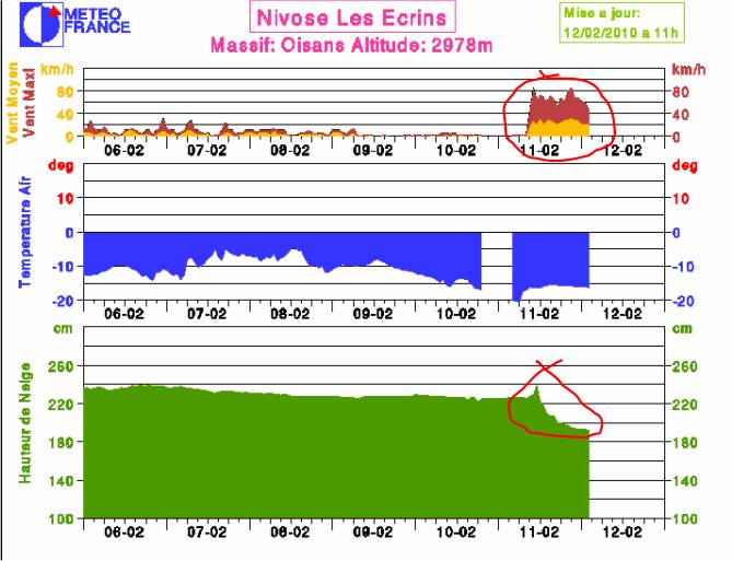
It has been snowing on and off over the last few days but after a short increase the snow depth has dropped from 240 to 190cm, a loss of 50cm. Not a sudden thaw, the temperature is -16C, if you look at the wind column the average wind speed has been about 30km/h with gusts to 80km/h. Pretty strong stuff. There is no information about wind direction but judging by the temperature we are talking about north winds so that half meter of snow is going to be deposited somewhere on south facing slopes. However things are never that simple. If the slope has gulleys you may find it ends up largely on one bank. Throw in a few cols, ridges and summits and the snow may end up on east or west facings slopes. Not forgetting north facing or shaded slopes which have the most fragile layers.
Just to add some confusion take a look at the local avalanche bulletin
Vent à 1500m : nord à nord-est 40 puis 20 km/h -Vent à 3000m : sud à sud-est 10/20 km/h.
So at 1500 meters we have a fairly windy north to north easterly but climb to 3000m and that drops to a moderate to calm southerly wind. The bulletin continues
Des combes chargées de 2 à 3m neige alternent avec des crêtes où la neige a été arrachée.
Bowls loade dwith 2 - 3 meters of snow but ridgelines stripped bare, exactly what we see in the graphic. The bulletin talks of avalanches of over meter in depth on north facing slopes with slabs on south facing slopes (which we can suppose from the graphic) too.
Sur Oisans et Grandes-Rousses, les versants abrités des vents de nord-est ont vu la formation durant les dernières 24 h de nouvelles plaques d’apparence poudreuse et d’autre part les orientations nord conservent des couches fragiles sur une forte épaisseur.
Again confirmed by the graphic. Slabs on south -> south-west facing slopes but still a significant danger on north facing slopes due to weak layers.
A complex situation which merits the risk rating of Considerable tomorrow.