Haute Savoie Avalanche Bulletin
Avalanches > Avalanche Bulletin > Haute Savoie Avalanche Bulletin
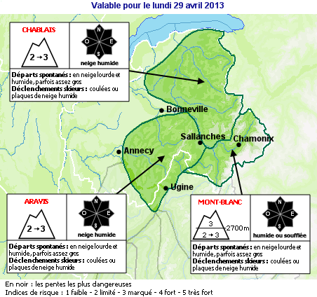
This bulletin is produced from an automatic translation using a specialized dictionary for words and phrases relating to snow and avalanches. It should only be used as a complement to the actual bulletin in French. There are a number of reasons why the translation is imperfect including colloquialisms use of French, spelling and grammar errors and complicated sentences.
N74090511
SNOW AND INFORMATION AVALANCHE for the Haute Savoie
(VALID OUTSIDE OF MARKED AND OPEN SKI RUNS)
PREPARED ON FRIDAY MAY 9, 2008
INFORMATION FROM REDUCED
SNOW CONDITIONS:
Finally good! after a month of February largely dominated by the sun, it was feared the worst ....< BR> but a time often disrupted and relatively cold in April helped change the situation. Currently, the snow is therefore still higher than 1800/2000 m away.
Towards 2000 m due north east total thickness of 1SNOW CONDITIONS0 to 1WEATHER OUTLOOK0. Some
parking on snow may still be around 1500 m north somewhat cloudy, but rather south around 1800 m earlier in the slopes to buff ... In
high elevations, conditions are good in general, with parties still well under ice (to the peaks, ridges, blast corridors). Some bridges snow weaken in the afternoon in the lower parts of glaciers.
ESTIMATE OF RECENT SNOWFALL:
last week, time is kept dry. The last snowfall back to Wednesday, April 30 where he fell between 15 and 25 cm above 2,000 m.
STATE OF THE SNOW THIS FRIDAY MAY 9: In
mid elevations, after a low-back, sun and Isotherm to 3200 m gives a snowpack quickly rotted on its thickness and therefore in favour of substantive departures. The slopes to 2500 m north limit insensitive maintaining a bearing surface ski much of the morning. In
high elevations, conditions for skiing remain pleasant, it's hard until late morning and then returned it to surface in the sun. The northern slopes are high-altitude cold compacted snow. At these high altitudes, the snowpack is relatively stable.
TREND FOR THE COMING DAYS:
Saturday, May 10: nice and warm and then the cloud formations, dans le mountain range of Mt Blanc Foehn irregular cloudy with a few passages. For outings mid elevations be taken into account enneigements still substantial and a snowpack quickly moistened on its thickness with the result of departures of avalanches substance. Avalanches sometimes quite large, not necessarily in the usual areas and falling well below. While watching the slopes upstream in places cashed overcome major corridors and walls. During a hike in the afternoon, beware of snow surface full of water that slips under the skis or snowshoes and hand slides. In steep slope with a bottleneck or a rock downstream, the consequences may be amplified.
High elevations In a generally stable snowpack allows to evolve in good condition, remains the case even when an avalanche caused by a serac fall.
Sunday 11 and Monday, May 12: cloudy and hot, sunny afternoon. Foehn moments in the MT-Blanc. Also risk of wet snow avalanches in mid elevations. In high elevations possible formation of a plate of cold snow to a collar or a summit during a snow giboulée sustainable.
This information will be renewed no later than Tuesday, May 13
<< | Avalanche Bulletin | Savoie Avalanche Bulletin >>
Page last modified on December 19, 2006, at 02:48 PM
About PisteHors
