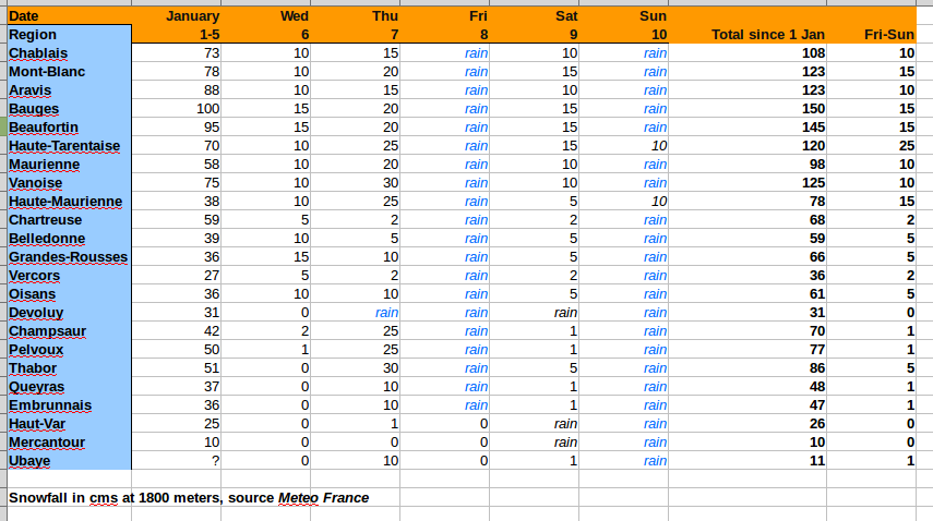
Well the weekend was a bit of a washout in many areas. The Haute-Tarentaise which has some of the biggest French ski resorts didn't fare too badly with snow on both Saturday and Sunday given a nice 25cm in total at 1800 meters with snow down to lower altitudes: 1400 to 1600 meters. You can find Val d'Isere, les Arcs, Tignes, la Plagne, Ste Foy and la Rosiere in this area.
Despite some rain on lower slopes, pistes were in skiable condition down to around 1400 meters. This is the place to be at the moment but with one caveat. Storm force winds have closed lifts and links and the fresh snow has left most of the Savoie mountain ranges with HIGH (maximum for skiers) avalanche risk. With a lot more snow on the way things can only get worse. Storm force north and westerly winds will lead to a lot of snow transport with some very big slabs forming. The high level rain has created a very complex snow pack with a mix of rain and wind crusts as well as graupel (hail). Massive natural avalanches down to ground level are to be expected in some areas over the next 24 hours.
Things are calmer in the Isere but there is less snow and substantial rain over the weekend. At altitude there is still over a meter of wind blown snow leaving with localized risk of skier triggered slabs. The high Pelvoux and Chamsaur mountain of the Hautes-Alpes have picked up around a meter of snow over the weekend and again the risk of avalanche is HIGH.