As we reported earlier in the week France is in the grip of severe winter weather. In the Rhône-Alpes region wood for heating is now in short supply and on the Cote d’Azur lemons have been frozen on the branch. The cold weather means that conditions normally associated with January and February will persist into March including an increased risk of avalanches. There has been little rain at even mid-altitudes during the winter to stablize weak layers and these remain on north sector slopes and on east to west sectors at altitude.
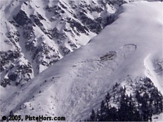
Avalanche on west facing slope yesterday
The weather is still cold with the zero isotherm around ground level. Fresh snow is moving north from the Isère into the Savoie and Haute-Savoie with the strengthening south-west wind shifting to the north-east to north. This snow will continue through Saturday and will slightly increase the risk of avalanches and form some new slabs on lee slopes particularly close to ridgelines and rollovers. We also noticed a layer of fragile surface hoar forming on shaded slopes during the week at lower altitudes.
The conditions are excellent with powder snow on North sector slopes although a breakable crust had formed on lower south-east to south-west facing slopes during the week, this will be covered by the fresh snow. It is possible to ski from 600-800 meters. The snow depths are below average at altitude and skiers travelling on glaciers should take precautions. A number of falls have been reported including one man who had a lucky escape after falling 25 meters into a crevasse on the Vallée Blanche.
The recent south-west wind earlier in the week will probably have formed some fresh soft slabs. Care should be taken on north half sector slopes and east to west slopes at altitude where there are some fragile layers in the snow pack formed by the recent cold weather. There are also some localized large slabs which will be loaded by the new snow. The risk of a small slab triggered by a single backcountry traveler exists and larger slabs may be sensitive to higher loads such as a group of skiers or the pressure from a small avalanche.
Update 6/Mar/2005- Belledonne, Vercors and Chartreuse
There has been well over 50cm of fresh snow in the Belledonne, Vercors and Chartreuse over the last 48 hours accompanied by a moderate north wind. The fresh snow is very cold and light and can easily be moved around by the wind. This morning we noticed some thin soft snow slabs that had formed and these will have grown and be more significant at higher altitudes. The fresh snow is often lying on weak layers on north sector slopes or hard snow close to ridges which could form a sliding surface. Natural sluffing is to be expected on steep slopes if there is any sun.
Southern]http://pistehors.com/backcountry/wiki/Ski-Areas/Southern-Alps]Southern Alps[/url]
A weather system moving up from the Mediterranean has finally given the Southern Alpes some respite with around 40cm of snow in the Alpes Maritimes dropping to 20cm further North. The conditions in the Devoluy massif could even be described as okay. Despite the wintery look to the region you still have to climb to around 1500 meters on North facing slopes before there is any skiing off-piste. The weather has been quite cold but the zero isotherm will rise to 2200 meters by midday. The wind will turn from a moderate south-westerly to a strengthening north-east to northerly. This may form some new slabs on lee slopes.
Many ridges and summits are still bare from strong north winds but there are some large accumulations of snow in sheltered areas. There are powder skiing conditions and the snowpack is generally stable after a long period of fine weather. However skiers should take care above 2200 meters, especially in areas that have had a lot of recent snow. There are some weak recent snow layers or ice on shaded slopes and these could be the catalyst for an avalanche. The warm weather today could lead to some snow sluffs on steeper slopes.
References
This information is a summary of current conditions and is provided for information only. It is based on direct observations and information from the following sources.
Météo France issues daily avalanche bulletins for the French Alps, Corsica and Andorra. You should ideally consult at least the previous 5 days bulletins prior to your trip in order to have an idea of recent conditions.
recorded in Camp2Camp and Bivouak have trip reports with observations of the snow conditions.
Weather information is complemented by the USAF Public Weather Charts
Henry’s Avalanche Talk publishes a daily translation of the Météo France bulletin for the Savoie area.