Snow and Avalanche Report: Week 8-2005
Winter has continued this week with severe weather hitting much of France. Even the seaside town of Nice awoke one morning to 5cm of fresh snow covering the palm trees and promenade. This brought little relief to the Southern Alps where with the exception of the areas bordering the Isère and Savoie the conditions are poor to awful.
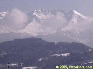
Belledonne Mountains at noon today
The snowfall caused less trouble than expected for skiers on the road last weekend except in the Massif Central where even the main motorways were closed for some time. The Haute-Loire department saw some roads closed due to avalanche risk. Munitions experts had to be brought in to blast suspect slopes and cornices, a rare site. In Chamonix two climbers were killed after a sérac (ice block) fall caused an avalanche on the glacier d’Argentiere and an off-piste skier was killed by an avalanche in Val Thorens. A group of seven skiers had a lucky escape in the mountains of Corsica although one of their number suffered a nasty broken thigh.
Northern Alps
It is a glorious sunny day in the Isère today with the clouds finally clearing from the Belledonne and Chartreuse mountains. We were ski touring in the Belledonne on Tuesday, climbing from 800 meters we encountered a band of cloud and snow before ascending into almost clear conditions at around 2000 meters. There has probably been around half a meter of fresh snow in the pre-Alps, slightly less elsewhere in the region except for the Vercors which saw 70cm of new snow. It is possible to ski to 800 to 500 meters altitude. Conditions are powder except for an early, light crust on warmer South to West slopes and packed snow on exposed ridges and cols.
The cold, calm weather, the -10 degree isotherm is around 2000 meters today, has continued to weaken the snow. We noticed surface facets forming on the snow on Tuesday.
The calmer weather over the last couple of days has helped stabilize the snow. The avalanche risk is greatest above 2000-2200 meters where there has been no rainfall to stabilize deeper, weak layers this winter and the recent cold weather has continued to transform the snowpack. This principally affects the Vanoise, Tarentaise in the Savoie, the Mont Blanc massif and the Belledonne, Grandes Rousse and Oisans. (l’Alpe d’Huez, les Deux Alpes, la Grave) mountains in the Isère. Glaciated terrain in the Oisans may also have weak snow bridges.
Strong North winds before last weekend and from the South to East at high altitude yesterday have formed some new slabs. Take care on North to East and possibly West sector slopes, especially with thin, weaker snowpacks, on convex slopes, the base of cliffs and routes that have not been stabilized by frequent skiing, Keep a safe distance from other skiers. Some localized slabs are sensitive to the weight of a single skier, snowboarder or snowshoer. There is the possibility of snow sluffs on steeper, sunny slopes.
Southern]http://pistehors.com/backcountry/wiki/Ski-Areas/Southern-Alps]Southern Alps[/url]
Saturday will see a few clouds move across the region bringing some snow flurries. Temperatures will warm during the day with the zero isotherm rising to 1000 meters coupled by a light South-West, veering Northerly wind.
Snow cover is poor to awful on all ranges except the North-West of the Thabor, the Dévoluy and some limited areas in the Maritime Alps. Ski mountaineers reported some fresh snow and good skiing conditions in both these areas during the week but with snow cover only really skiable from 1400 meters. On South facing slopes there is little skiable snow off-piste below 2000 to 2500 meters. Ski tours often have to be finished on foot as summits and ridges are rocky or icy.
The lack of snow means less risk of avalanches with some slabs formed by the recent light snow above 2200 meters on North and East slopes. These are sometimes lying on unstable layers. There is also the risk of some soft slab avalanches with the recent snow on slopes close to summits or steep bowls. The conditions will not evolve much in the cold conditions.
Corsica
Some fresh snow is expected at the end of Saturday morning accompanied by light to moderate winds from the North-West. The zero isotherm will descend from 1100 to 900 meters over the course of the day. According to Météo France the snow cover is excellent but not as good as 98/99 which set a record for the last 30 years. Still it is possible to ski to 900 meters. Powder can be found in sheltered areas and in forests but the conditions are irregular elsewhere.
There has been over a meter of snow in some areas over the last week accompanied by strong West winds. A number of slabs have formed, particularly on Eastern slopes and these are sitting on an older unstable layer. These could be triggered by a single backcountry traveler.
Pyrénées
Snow cover is excellent, it is possible to ski from 700 meters in the West, 1200 meters in the East with powder on Northern aspects and a breakable crust on South facing slopes. The weather station at Maupas (2430m) in the Haute Garonne is currently recording over 3 meters total snow depth. The snow on ridges and cols is often very hard and sometimes icy. There has been around 40-70cm of snow over the last week except in the East which has seen between 10-40cm. Some light snow is expected on Saturday later in the day in the West of the range accompanied by a light west to north wind.
The cold weather, the zero isotherm estimated at 700 to 900 m on Saturday, is slowing down the stabilization of the snowpack. The recent snow accompanied by a strong North-West wind has created some new soft slabs even at quite low altitudes. These could be triggered by a single backcountry traveler. In the West care should be taken on rollovers on in the South to East sector. In Central areas the many layers in the snowpack are poorly bonded presenting a risk over 2000 m on North half sector slopes. There are some large, localized hard slabs dating from before last weekend that could be triggered by the passage of a group of skiers. These are often hidden by the recent snow. These are more common to the East of the range where there are some large accumulations in sheltered areas.
References
This information is a summary of current conditions and is provided for information only. It is based on direct observations and information from the following sources.
Météo France issues daily avalanche bulletins for the French Alps, Corsica and Andorra. You should ideally consult at least the previous 5 days bulletins prior to your trip in order to have an idea of recent conditions.
recorded in Camp2Camp and Bivouak have trip reports with observations of the snow conditions.
Weather information is complemented by the USAF Public Weather Charts
Henry’s Avalanche Talk publishes a daily translation of the Météo France bulletin for the Savoie area.
Posted by
davidof on Friday, 25 February, 2005 at 02:34 PM
The PGHM in Chamonix were busy over the weekend including the rescue of a man who had fallen some 25 meters into a Crevasse on the Vallée Blanche. The man was recovered by the rescue services with hardly a scratch!
Posted by
davidof on Monday, 28 February, 2005 at 04:57 PM
Page 1 of 1 pages
Comments are now closed