Géoportail - Google Earth rival is French Fried!
Unveiled in a blaze of publicity by none other than French President Jacques Chirac, Géoportail, the French “Google Earth – but better” was supposed to be a showcase of French mapping and information technology prowess. The site, which has been developed by Institut Géographique National (IGN – National Geographic Institute) at a cost of around 6 million euros contains 3,700 topographical maps and 400,000 aerial photographs with a 50 cm resolution. The IGN is 55% funded by the French tax payer.
Sorry we are closed
The launch was held last Friday at the Elysées palace. Chirac proudly crowed that the site would “put France at the forefront of new technologies”. He is known not to be a fan of American information giant Google and has probably not been impressed by the high resolution 3-D imagery they offer of the Elysées Palace and other top secret government establishments.
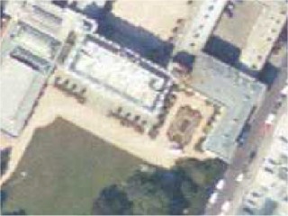
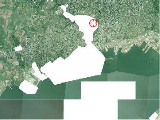
See the grass grow - Google Earth (right) has the edge in Paris
At precisely 11am last Friday the French President clicked a mouse and the site was declared open… and promptly crashed as up to 600 requests per second overloaded the Redhat Linux based computer running version 2 of the open source Apache web server. Since then the home page has been intermittently accessible but the only people, apart from Jacques Chirac, to see the quality of the images have been a few privileged journalists.
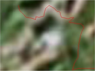
Over much of the country Google Earth is no match for Géoportail (left)
The IGN used technology partners Teamlog and Digitek to help build the site, which is exclusively web based. In February the project chief Patrick Leboeuf said he expected 500,000 unique visitors during the first year, in fact they had they during the first 24 hours. Even the IGN’s main site suffered from the knock on effects. Alexa’s traffic rank showed a huge jump from Internet backwater to raging bit torent.
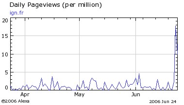
IGN’s web traffic rockets
Géoportail will cover all French territories but doesn’t have any designs to expand into Europe or beyond. Unlike Google the idea is to offer a public service with all areas treated with equal resolution. The functionaries of the IGN were somewhat condescending to Google’s freemarket, commercial approach promising that any advertising on their site would be clearly separated from the functionality. Asked if Géoportail had been launched to compete with Google Earth they said that they had been thinking about such a project for a number of years.
The eventual aim of Géoportail is to integrate other data such as zoning maps for town planning so that the site really does become a portal for users ranging from people wanting to take a look at their house from the air, to sportsmen such as users of our site, PisteHors.com, who will be able to plan and visualize ski trips to professionals involved in construction projects or local administration. Unlike Google Earth each image will be dated. Due to the current difficulty accessing the site it is not yet clear whether the data formats for visualizing waypoints and routes will be documented like Google’s Keyhole Markup Language or if the site will run on web browsers other than Microsoft’s Internet Explorer.
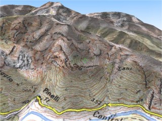
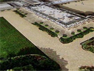
The future? 3D topography with map overlay
Unlike Google Earth the site currently offers a flat view of France. A three-dimensional site will be ready in the autumn but given Geoportail’s difficult birth it is not known when it will be launched. The IGN do not want a repeat of this week’s problems which has subjected them to heavy criticism in the media. In fairness 6 million euros is not a large budget for such a project but they could learn one thing from Google. Launch quietly rather than in a blaze of publicity.
website: http://www.geoportail.fr/
Posted by
davidof on Monday, 26 June, 2006 at 09:32 AM
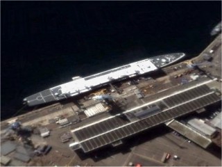
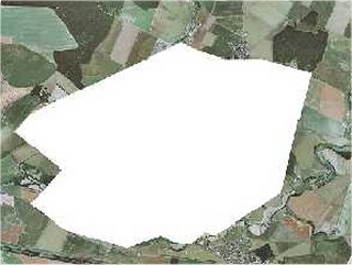
One you won’t see with Geoportail. The experimental French missile ship la Monge docked at Brest harbour. The whole of the naval installation in Brest is one big blank:
Posted by
davidof on Tuesday, 27 June, 2006 at 11:55 PM
AWACs at top secret Avord airbase
with Geoportail… nada
Posted by
davidof on Wednesday, 28 June, 2006 at 12:08 AM
The IGN Geoportail site is working from today. The overview map of the World gives a fascinating glimpse into France’s colonial remains. You wonder why France needs all these little islands dotted about the World. Unfortunately we couldn’t look at New Caledonia to see what effect the atomic bomb tests of 1995 had had on the coral reef as there was a bug at the time of writing in the display.
You can search for a town and then see photographs of the area. Some of the photographs are quite old it would seem judging by the building that has gone on since.
There is no way to enter GPS coordinates or overlay GPS maps for the moment but clicking on the X/Y icon at the top right of the map will give you the latitude and longitude for a selected point on the map. The site seemed to work okay with Mozilla Firefox and was acceptably fast.
You switch from a photographic view to a map or relief view. In brief good news but progress needed for this to be a useful tool. Hopefully it will spur Google on to provide high resolution photography for the rest of France.
Posted by on Saturday, 01 July, 2006 at 12:57 AM
Page 1 of 1 pages
Comments are now closed