Google Earth zooms in on France
Regulars of PisteHors will know that we have been making some of our GPS routes and trips available in Google Earth’s Keyhole Markup Language (KML) format. These files can be viewed in 3D using the Google Earth application. However outside of urban areas resolution was a bit fuzzy, to say the most.
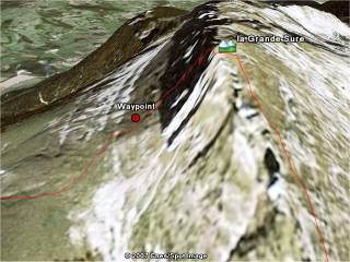
The Grand Sure, as seen by Google Earth
Now Google has teamed up with Toulouse based satellite photography experts Spot Image to improve the resolution Europe, and in particular the French mountains. The photographs from the SPOT 5 satellite is 2.5 meter resolution and we must say that for the most part the results are excellent.
You may need to upgrade to Google Earth version 4.0 for best results.
This is a reminder to our readers that if you have routes - off-piste or ski touring and want to share the information that they can upload them to our Wiki. You will need to convert them to the Google Earth file format first. Otherwise Zip up your GPS file and email it directly to us.
Edit the page you want to add a new route to. If the page doesn’t exist put a link to the new route in an appropriate page using the Wiki [[link]] notation, save the page then click on the link.
We have a standard template for routes although this is not currently deployed throughout the site. In this case look for the following line:
||!GPS Route ||Google-Earth: ||
otherwise create a new line at the bottom of the page
To upload your route add the name of the Google KMZ file (this is a compressed Google keyhole markup language file):
||!GPS Route ||Attach:Grands-Moulins.kmz ||
Save the page and you will see a link.
Click on the link and you will be prompted to upload a file. Only kmz file types are permitted with a maximum size of 50kilobytes (normally routes are about 5-10k). Click the upload button and your route will be transfered to our server and included in the page.
Here is an example for the Aiguillettes de Vaujany.
Posted by
davidof on Wednesday, 24 January, 2007 at 03:56 PM
Lookup france locations on satellitepictures at streetlevel by address and also worldwide?
PICSFROMSPACE, Lookup Your Place By Address,since september 12th more then 250,000 requests at:
http://www.walweb.nl/picsfromsapce
Posted by
walweb on Thursday, 25 January, 2007 at 08:57 AM
Page 1 of 1 pages
Comments are now closed