This is an archive of the old PisteHors.com forum

News | Gear | Ski Areas | Hiking | Mountain Biking
Powered by Google™
   
 
Temperature Gradients and the White Death
Posted: 10 November 2009 03:33 PM  
Administrator
RankRankRankRank
Total Posts:  2234
Joined  2003-10-24

I was out this morning in the Chartreuse. Around 1650 meters I skinned over a small shrub, but it could just have easily been a rock and I took this photo which illustrates a point quite well

DSCF2415.JPG

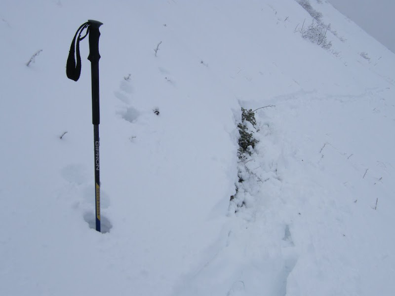
You can see from the ski pole, which was down as far a solid snow base, that there is around 40cm of snow depth on the slope. However above the shrub there is just 20cm. The air temperature was around -4C at the time. So the general temperature gradient (TG) from ground to surface is around 10C/meter. That is enough to cause water in the snowpack to sublimate, that is turn from a solid to vapour then refreeze. This transforms snow crystals into facets and eventually depth hoar. Both of these constitute weak layers in the snow pack and are a major factor in skier triggered avalanches.

But what of the shrub. Well with just 20cm of depth and a nice warm air pocket below the TG is more like 20C/meter. This is going to be developing depth hoar quicker than a teenager develops acne. Holy spatial variability batman! This spot could be the trigger point, that extra weak area, that causes the whole slope to slide. Okay what normally happens is that at this altitude we get some rain early in the season that then refreezes the snow pack solid. But this isn’t the case above 2000-2200 meters.

The flowcapt thread got me crunching the numbers a bit

http://pistehors.com/news/forums/viewthread/367/

If we take the Meteo France Monitoring station in the Belledonne we see that there is a strong temperature gradient of

http://www.meteo.fr/temps/france/nivose/pics/DUPINS.gif

14C / meter, same at la Chevril (on the Flowcapt data set, see first link). Even more elsewhere. We can assume that facets and depth hoar, which our French friends call gobelet (they resemble and have the strength of champagne glasses) will be forming or have already formed on north faces. The cold north facing Freydane bowl opposite my house has had a thin snow covering for the last couple of weeks. There was also an episode of foehn (a strong southerly wind) on the 7th which transported some snow onto these faces.

The snow this morning was powder but fairly cohesive in places. There were 2 / 3 layers at 1750 meters representing the recent snow episodes. So the situation, to me, seems to be getting complicated. These interfaces between layers might form sliding beds and the cohesive powder a soft slab. I’m not hugely worried at 1750m but thinking more of the 2000-3000 meter range where there is already quite a lot of snow that can be mobilized in the event of a slide.

Certainly enough to kill a man. Remember the accidents of last November.

http://pistehors.com/news/ski/comments/0866-avalanche-sorbier/

Snow levels are already approaching those of the last week of November 2008.

Take care out there.


Posted: 11 November 2009 05:41 AM   [ # 1 ]  
Sr. Member
RankRankRankRank
Total Posts:  270
Joined  2008-01-31

Nice to have a demonstration of calculating a “general estimate” of Temperature Gradient from the snow sensor data.
And then pointing out the big problem that the specific local TG is different from the “generally” calculated TG.

Which spurred me to read the relevant pages in Bruce Tremper’s book. Some things that struck me that he mentions regarding uneven distribution of depth hoar / TG snow are:
(a) thin snow over and around rocks in the middle of slope.
(b) gradient based on factors other than the difference between air temp and ground temp: especially greater radiative heating / cooling on northerly versus southerly aspects.
(c) local differences in air temp: esp. cold air trapped in valley bottoms.

Some of what he wrote seemed to imply that avalanche professionals might actually stick thermometers into the snow at different depths. Maybe that’s how Tremper knows to emphasize the relative importance of differences in radiative heating/cooling at mid-latitudes like the French Alps.
(Which I think tends to imply that the depth hoar / TG snow is worse in thin snow on northerly aspects than might have been thought from the general estimates.)

For me the implication is:
Be more scared of what we don’t know.

Ken


Posted: 12 November 2009 03:16 PM   [ # 2 ]  
Administrator
RankRankRankRank
Total Posts:  2234
Joined  2003-10-24

Here is a snowpit diagram I did and it shows a strong TG in the top layer of the snow between the air and a layer of ice then a much lower temperature gradient lower down.

profile.jpg

what might now happen is that you get a weak layer forming around this ice layer like this:-\

sand-layer-tg.jpg

which, when covered with more snow is a recipe for avalanches.

If you have a TG of more than 10C > meter then, whatever the exactly distribution in the snowpack, somewhere in there you will be getting facetted crystal growth. If I go out tomorrow I’ll try to get some more beta.

[ Edited: 12 November 2009 04:05 PM by davidof]
 
 
Posted: 13 November 2009 01:47 AM   [ # 3 ]  
Sr. Member
RankRankRankRank
Total Posts:  270
Joined  2008-01-31

The point about 10C per meter promoting growth of “depth hoar” / TG snow is basically correct I think.
Two caveats:

(a) If I’m calculating the Temperature Gradient based on measured _air_ temperature (presumably just above the surface of the snow versus estimated ground temperature (below the snowpack)—which is the obvious easiest way, that misses the contribution of radiative warming on sun-exposed slopes during the day. Sunlight can directly transmit heat energy to the surface of the snowpack without warming the air just above it much—so the heat-based vapor transport inside the snowpack is less than predicted by the obvious measurement. A possibly inaccurate way to think of it is that the “effective” temperature just inside the surface of the snow in sunshine is higher than the measured air temperature just above the surface.

(b) my reading of the Bruce Tremper book suggests that the TG crystal formation process is partly reversible. If so then some crystal formation with larger temperature gradient (often combined with radiative cooling) at night could be reversed by the smaller temperature gradient during the day (especially if combined with strong radiative warming).

So the basic message that a “general”, “average over the 24-hour day” temperature gradient greater than 10C per meter is a sign of likely formation of dangerous TG crystals, but the local and hourly variations can be substantial.

Another reason why avalanche forecasting is a tricky business.

Ken


Posted: 14 November 2009 08:50 AM   [ # 4 ]  
Sr. Member
RankRankRankRank
Total Posts:  109
Joined  2006-03-05

According to ANENA (French avalanche association) stats, one avalanche death in six happens outside of the “ski season”. Early snow is of course part of that with depth hoar and bad adhesion to ground.

I think it is more tricky to evaluate risks at the start of the season. Later, with more snow depth, not only the risk of hoar is reducing and ground adhesion is more solid, but from my perception snow conditions are more homogenous. At the beginning of the winter, move 5 meters away and it can be totally different…