This is an archive of the old PisteHors.com forum

News | Gear | Ski Areas | Hiking | Mountain Biking
Powered by Google™
   
1 of 2
1
January 2009 Snow Conditions
Posted: 02 January 2009 08:37 PM  
Administrator
RankRankRankRank
Total Posts:  2234
Joined  2003-10-24

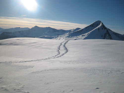
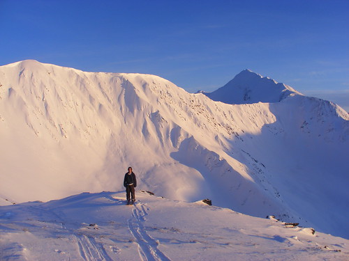
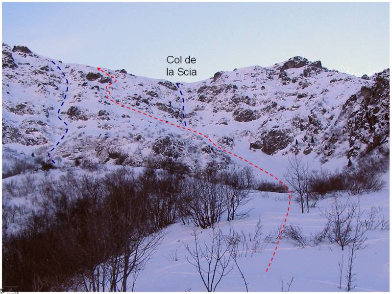
First trip of the new year was to nearly la Scia in the Belledonne. The north couloir from the col didn’t have enough snow to be skiable (rocks) so I zig-zagged up the face before stopping below the summit due to lack of time.

We had 10cm of snow on the 31st-1st at 2000 meters. It actually rained up to 1500 meters which didn’t please our local ski resort which had iced ski runs on the 1st. However the new year was warm and the lower slopes soon turned slushy. This meant that today we had a bit of a mixed bag with fresh snow (about 5cm at 1500 meters) sitting on a freeze crust. Only when you get above 1800 meters do you find a solid base to ski on.

trace.jpg

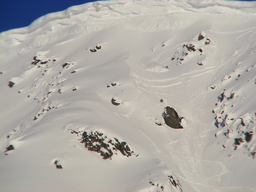
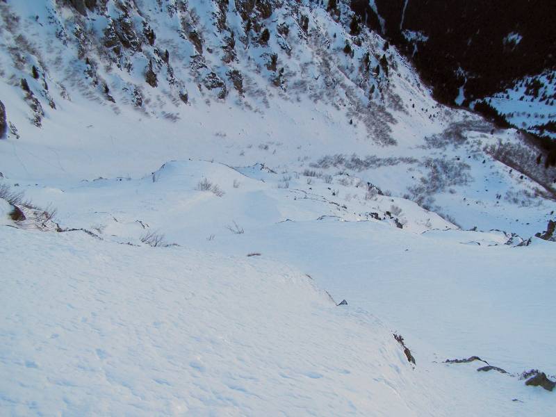
Conditions on the Scia were a bit of a mixed bag. Hard snow, a thin crust and powder on a firm base in the dips. The powder was cohesive in places and broke away in small slabs but everything seemed pretty solid. Slightly more worrying were the old “sugar snow” and depth hoar. I had to crampon the last 150 meters and in places you could sink down to the rocks 50-100cm below. In places slabs were sitting on this layer.

descent.jpg

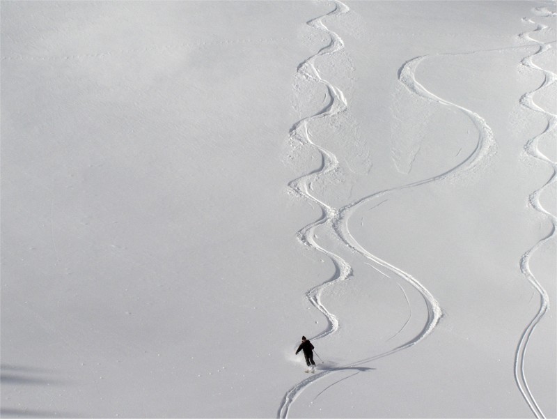
I took the steep top section section very gingerly, not keen to overload the snowpack but slightly lower down it was good skiing on a firm and solid base.

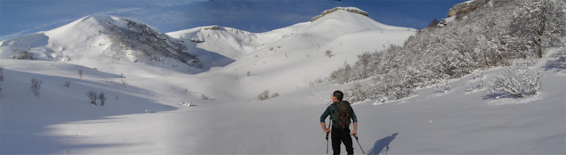
Friends skiing further north reported 20cm of fresh. Not enough to bury old tracks but good skiing none the less.

In conclusion, things in the northern alps seem pretty stable at the moment with some localized slabs at altitude particuarly on north-west exposures. The thinn snowpack at altitude is worrying with a lot of uncohesive snow about the place on shaded slopes above 2000m. Take care around rock outcrops, base of cliffs, close to ridgelines etc. This will be a danger when we get a big dump. Snow conditions have not been wonderful - the south facing slopes have yielded the best skiing. We are promised a bit of snow on Monday.


Posted: 04 January 2009 01:44 AM   [ # 1 ]  
Sr. Member
RankRankRankRank
Total Posts:  139
Joined  2005-05-06

We were luckier in the North. Here in Morzine we had rain to about 1300m but above that 30cm of dry snow. Certainly enough to cover the old tracks.

3164060955_3c72197a6e.jpg

This photo was taken at 1600m.

I went out on skis yesterday, a very mellow trip, we only had a few hours to spare in the afternoon. A video here http://www.chaletgeorge.com/.

 Signature 

http://www.alpine-property.com


Posted: 08 January 2009 02:49 PM   [ # 2 ]  
Newbie
Rank
Total Posts:  5
Joined  2008-12-09

The Eastern Alps keep cold and dry, with intense hoar formation.  This will be a potential weak layer when snowfalls return.  Watch your first hors piste turns there!

picture-3.jpg
Ehrwald 6/1/09

[ Edited: 10 January 2009 10:32 AM by patagon]
 
 
Posted: 08 January 2009 05:07 PM   [ # 3 ]  
Administrator
RankRankRankRank
Total Posts:  2234
Joined  2003-10-24

Yes I think there are going to be a few problems when we finally get some new snow (2010 if you believe the long range weather forecast grin ). In the Northern Alps the snow depths are quite thin away from the frontier zone with Italy with very cold air temperatures - below -10C at 2000m. That means a steep temperature gradient between the surface and ground and the formation of weak layers, in particular depth hoar although you are probably getting a lot of surface hoar in the mix too. It is going to be explosive :-(.


Posted: 10 January 2009 09:20 PM   [ # 4 ]  
Administrator
RankRankRankRank
Total Posts:  2234
Joined  2003-10-24

Been out today in the Chartreuse. We climbed from Perquelin near the ski resort of St Pierre de Chartreuse via the combe de Prayet - a steep gorge that I walked a couple of summers ago

http://pistehors.com/hiking/wiki/Chartreuse/Le-Prayet

The snow wasn’t bad from 1200-1500 but there was nothing to speak of in the Prayet until 1600 when a layer of fresh powder appeared (from the 5-15cm that fell midweek). We then climbed to the Roche Plan (1930 meters) before skiing down via the combe sans nom.

http://pistehors.com/backcountry/wiki/Isere-Drome/Rochers-Du-Midi-Via-Sources-Du-Guiers

which was a trial for Fred as he was on a snowboard and had to make a 500 meter horizontal traverse in waist deep snow. The combe sans nom was about 5cm of fresh snow on old tracks, better than the Prayet but not fantastic.

So good snow above 1500m in the Chartreuse, which seems to be the case from other reports that I’ve seen.


Posted: 12 January 2009 10:54 PM   [ # 5 ]  
Sr. Member
RankRankRankRank
Total Posts:  109
Joined  2006-03-05

Hard and often icy snow all over the Sancy, one has to choose the right orientation and time of the day to have safe and pleasant turns.

Here going down the couloir S at the Sancy, mid afternoon, in good conditions.

web.jpg

Warmer temperatures means wider possibilities in the coming days


Posted: 13 January 2009 09:39 AM   [ # 6 ]  
Administrator
RankRankRankRank
Total Posts:  2234
Joined  2003-10-24

Nice spring snow Eric. I see there has been quite some activity around the Mezenc as well. Here are a few clips from the Chartreuse

http://vimeo.com/2806634

I didn’t bother with all the “ski bucheron” in the forest so it maybe looks better than it was!


Posted: 13 January 2009 09:43 PM   [ # 7 ]  
Sr. Member
RankRankRankRank
Total Posts:  110
Joined  2008-11-05
davidof - 08 January 2009 05:07 PM

Yes I think there are going to be a few problems when we finally get some new snow (2010 if you believe the long range weather forecast grin ). In the Northern Alps the snow depths are quite thin away from the frontier zone with Italy with very cold air temperatures - below -10C at 2000m. That means a steep temperature gradient between the surface and ground and the formation of weak layers, in particular depth hoar although you are probably getting a lot of surface hoar in the mix too. It is going to be explosive :-(.

depth hoar everywhere around Courchevel/Meribel, plenty of surface hoar turning up each day too.  If you are lucky the sun can leave some spring like snow, can be the main word.  also some north facing slopes, particularly couloirs which have not had so much wind are still good choices.

been around Aiguille de fruit today which was ok.  did notice several small avalanches on mostly south facing slopes where the sun has just heated the thin layer up so much.

i think, if there is snow lots of snow soon, there could be lots of trouble, i just hope there is no one injured.  im not experienced in comparison of say Davidof and others, but i think many people will rush out once powder comes and hit up slopes where there are old wind slabs and generally unstably snow packs.

depth hoar you whore!


Posted: 14 January 2009 12:05 PM   [ # 8 ]  
Newbie
Rank
Total Posts:  5
Joined  2008-12-09

A short video for the telemarkers out there:

http://66.246.75.103/photosL/pwdrgr.html

Some days ago in Tirol.
(it requires quicktime)


Posted: 19 January 2009 11:14 AM   [ # 9 ]  
Administrator
RankRankRankRank
Total Posts:  2234
Joined  2003-10-24

On Saturday I was in the Vercors skiing at the Col d’Arzellier - a few lifts on a mountain pass with a bit of a wild west feel. The sun remained obscured all day but was just powerful enough to melt the surface of the snow giving some reasonable soft snow on south-east slopes. The only problem is the lack of snow since the start of December has left these self-same slopes a bit bare.

Sunday and a weather front moved in with a big rise in temperatures. So much so that -1C at 8am felt positively warm. So far there has only been a dusting and with the zero isotherm around 1800 meters (snow line 1500 meters) things are not going to improve a lot. Another system is supposed to be making its way across the mountains today and tomorrow but again with little snow forecast.

In the Hautes-Alpes the col de Larche is still closed one month after the monster falls on the frontier with Italy. It may reopen this week but the Italians were still 1km from the summit on Friday. There has been further fresh snow with avalanches in the Fournel valley affecting some ice climbing routes. Care is in order.


Posted: 23 January 2009 10:13 AM   [ # 10 ]  
Administrator
RankRankRankRank
Total Posts:  2234
Joined  2003-10-24

Yesterday we were out in the Jura taking advantage of a couple of days break between weather systems. There is fresh snow down to around 900-1000 meters but not really skiable outside of the forest trails below 1200m. From 1350-1750, the summit of the Reculate, we were skinning in 20-30cm of powder on a solid and firm base (old transformed snow on east slopes).

Image1.jpg

There were some point avalanches on steeper east facing slopes that had caught the sun and already a sun crust on south and east aspects.

We descended direct from the summit down the east bowl, again light powder that had fallen without much wind and was a joy to ski.

Image4.jpg

Weather has changed today. The zero isotherm in the Haute-Savoie/Jura was around 1400 meters this morning with snow down to around 1100, I guess. There has been a lot of precipitation overnight and Meteo France are forecasting rain to 1900 meters during the day. Any snow will be accompanied by strong winds. Watch out for purges as the snow gets overloaded.


Posted: 23 January 2009 11:57 AM   [ # 11 ]  
Administrator
RankRankRankRank
Total Posts:  2234
Joined  2003-10-24

Conditions in the Southern Alps are very complicated. The col du Lauteret linking Grenoble to Briancon is closed due to an avalanche. The road from Grenoble to la Grave (RD 1091 - former RN91) was also closed but has now been reopened. The col de Larche has reopened finally. It has been snowing down to 400m but rain is expected to 1200m during Friday.

- 5 to 10 cm of snow at 400/500 meters
- 20 to 40 cm of snow at 800 meters
- 50 to 70 cm of snow from 1500 meters

As you can imagine this makes avalanche conditions very dangerous.


Posted: 26 January 2009 02:20 PM   [ # 12 ]  
Administrator
RankRankRankRank
Total Posts:  2234
Joined  2003-10-24

As you’ve probably seen on the main page there has been a lot of avalanche activity over the last week with the risk between 3 and 4 depending on the altitude. Here is a picture of the large slide in the small ski resort of Habere Poche which covered runs in the resort

habere-poche.jpg

There were a high proportion of young off piste skiers amongst the victims with accidents closed to ski runs. A reminder that whenever the slopes are steep enough there is a danger of avalanche. Terrain traps seem to have played a part as was a lack of avalanche rescue gear.

The good news is that conditions on south facing slopes are not too bad. The long period of settled weather in December and early January meant these slopes had seen a good freeze-thaw cycle. The rain on Friday to around 1800 meters has also penetrated the snow pack on all aspects and with the coldish weather of the last couple of days those slopes are much more stable.

Gilles Brunot of Meteo France’s Chamonix avalanche center gave this interesting explanation of the conditions over the last week.

There are risks that are persistent and short term risks. In general terms risk drops quickly after a large snow fall. We’ll look at that in details remembering that the main risk for a skier are slab avalanches.

If we say slab we are talking about the structure of a slab, that is a weak layer buried under normally (but not always) fresh snow.

If the weak layer is made up of facetted snow it will persist for a long time. The structure of the slab is therefore long lived but when the layer of snow above is thick (more than a meter) a skier doesn’t usually generate enough force to trigger the slab. The thicker the slab, the less likely it is to be triggered. When there is a big snowfall the danger is very high because of spontaneous avalanches triggered by the weight of the new snow. However the risk of skier triggered avalanches is lower.

If the weak layer is made up of recent cold and fresh snow (frequently the case with windslab where you have a succession of falls of cold snow followed by mild temperatures) then the weak layer is of short duration because the cold light snow will settle under the weight of the new snow. The more new snow the quicker it will settle.

There are two types of risk 4 (High)

A purely accidental risk when a moderate fall of new snow (30-70cm) rests on a weak layer. If the new snow rests on facetted snow (depth hoar) the risk is persistent. This is typically the case where we have most accidents and this is often the case where pros (guides, instructors etc) get caught This is frequently the situation at the start of winter following a long period of fine weather followed by moderate snowfall.

A natural risk when there is a lot of fresh snow with many spontaneous avalanches. In this case the weak layers are deeply buried (even more so when the risk is 5!) and they settle rapidly. The accident risk then drops rapidly.

In the Haute-Savoie the risk 4 early last week was of the first example, that of the last few days of the second type.


Posted: 26 January 2009 09:55 PM   [ # 13 ]  
Sr. Member
RankRankRankRank
Total Posts:  109
Joined  2006-03-05

Lots of snow and wind in Massif Central and a fantastic Sunday wink Excellent skiing - choosing the terrain to minimize risks. Pictures from Puy Redon and Val de Courre.

web.jpg

web.jpg


Posted: 27 January 2009 01:56 PM   [ # 14 ]  
Administrator
RankRankRankRank
Total Posts:  2234
Joined  2003-10-24

Wow, it looks like the Himalayas!

Here are some more avalanche facts from Montagnes Magazine:

Percentage of fatal avalanches in France
49% at risk 3
42% at risk 4
8% at risk 5

As Gilles Brunot, who I quoted earlier says, risk 5 we generally ski on “nordique” type routes, if at all. So the risk scale for skiing should be though at 1-4, risks 3 and 4 are in the top half of the risk scale and should both be treated with respect as they main that skier triggered avalanches are possible to probable.


Posted: 27 January 2009 09:29 PM   [ # 15 ]  
Jr. Member
RankRank
Total Posts:  40
Joined  2008-03-27

pretty good the last few days here
3232207302_eed4466213.jpg?v=0
and the place is
3231358877_301409d4f4.jpg?v=0

 Signature 

Dongshow Productions


1 of 2
1