This is an archive of the old PisteHors.com forum

News | Gear | Ski Areas | Hiking | Mountain Biking
Powered by Google™
   
2 of 2
2
December 2011 Snow Conditions
Posted: 21 December 2011 08:31 PM   [ # 16 ]  
Administrator
RankRankRankRank
Total Posts:  2234
Joined  2003-10-24

A bit of a thaw today, it is currently raining in the valley and probably up to 1500m. The champagne powder of Monday was more Warm Beer powder today. Nice but a lot heavier. Avalanche risk remains around 3/5 and I wouldn’t be surprised to see some purges as the snowpack gets overloaded.


Posted: 21 December 2011 10:30 PM   [ # 17 ]  
Sr. Member
RankRankRankRank
Total Posts:  139
Joined  2005-05-06

0C currently here at 860m in the Chablais, and a wet mist reminiscent of Bradford.

 Signature 

http://www.alpine-property.com


Posted: 22 December 2011 11:49 AM   [ # 18 ]  
Newbie
Rank
Total Posts:  1
Joined  2011-12-22
ise - 10 December 2011 09:09 PM

A couple of views of Friday,

Glacier 3000 in the morning and you can see snow down to around 1000m in the surrounding area. I should have taken a shot of the some of the ridges around Isenau where there a large amount of natural avalanche activity.

20111209-115458.jpg

And that afternoon looking over to Villars from above Leysin.

20111209-153109.jpg

This is good! Lots of snowsmile I’ll head to this awesome place immediately.

 Signature 

Screen recorder


Posted: 22 December 2011 02:14 PM   [ # 19 ]  
Sr. Member
RankRankRankRank
Total Posts:  139
Joined  2005-05-06

I had hoped the weather forecast of “rain to about 1500m” was wrong. I went out this morning, it is now raining to at least 1800m. what a shame. All that beautiful powder is now a soggy mess.

 Signature 

http://www.alpine-property.com


Posted: 22 December 2011 04:43 PM   [ # 20 ]  
Sr. Member
RankRankRankRank
Total Posts:  543
Joined  2006-01-24
endlessride - 22 December 2011 02:14 PM

I had hoped the weather forecast of “rain to about 1500m” was wrong. I went out this morning, it is now raining to at least 1800m. what a shame. All that beautiful powder is now a soggy mess.

or, ... “the base is consolidating nicely” LOL

I’m looking forward to these sunny days we’re forecast.

 Signature 

SwissMountainLeader.com & B&B L’Epicéa, Leysin, Switzerland


Posted: 22 December 2011 09:45 PM   [ # 21 ]  
Administrator
RankRankRankRank
Total Posts:  2234
Joined  2003-10-24

Yes I stuck to pistes today with the wee’un. Quite a lot of evidence of avalanche activity over the previous 24 hours, presumably as the snowpack got overloaded. Here is a full depth avalanche on an east facing slope at 1700m in the Chartreuse range.

P1020980.JPG height=481 width=640

These kind of slides are fairly typical here on the grassy slopes. You are not that likely to get caught by one as the weight of a skier is not sufficient to trigger the slide (unless there is a weak layer somewhere in the snowpack). With the refreeze tonight things should consolidate nicely with the avalanche risk coming right down in the Isere (sticking at 3 in the 2 Savoies, which might be a cause for concern on the first sunny day for some time) but expect crust and mush below 2000m tomorrow. Our plan is to tour from the top of the pistes at Chamrousse so we at least have pisted snow for the ski down. Might be a few purges still when the sun really gets going.


Posted: 23 December 2011 06:58 PM   [ # 22 ]  
Administrator
RankRankRankRank
Total Posts:  2234
Joined  2003-10-24

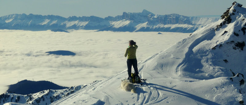
Just back from a day touring under a hot winter sun. Anticyclonic conditions were creating an inversion layer with a cloud sea blocking the valley with a ceiling around 1500m; this burnt off around the middle of the afternoon.

P1020984.JPG height=344 width=800

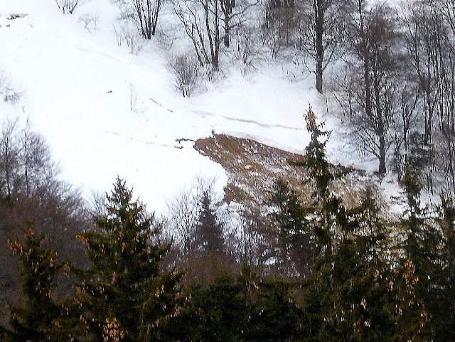
Things seemed very stable. We toured W - > SE slopes. In shaded spots it was largely wind or rain crust. Where the sun hit the snow this crust would melt leaving heavy snow. In the Vans bowl above Chamrousse it had largely been wind scoured leaving loose snow on hard pack that was very pleasant to ski.

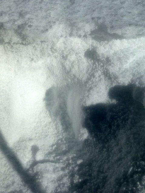
This interesting piece of wind sculpting is on a SE facing slope at 2200m on the side of a valley aligned SW <-> NE. Not easy to give a prevailing wind (any suggestions?) but it shows how fierce the wind had been.

P1020991.JPG height=600 width=800

The avalanche risk in the Isere is rising from the 1-2 today to 3 tomorrow with some fresh snow, maybe 20cm accompanied by strong winds from the NW -> N in the morning. Conversely the Savoie drops to a 2/3 break at 2300m, the forecaster sees less snow, maybe 5cm. Haute-Savoie has a similar picture to the Isere except the interior Mt Blanc range which will not see much snow.

Just a note, so far Meteo France has been a bit optimistic in its snow depths forecast in the new bulletin. Watch this space.

Not much avalanche activity. A skier triggered slide crossed an open piste in La Norma yesterday afternoon. More serious, a skier crossing a stream broke a snow bridge in l’Alpe d’Huez and was trapped in the water for 15 minutes before piste patrollers could haul him out.

[ Edited: 23 December 2011 07:03 PM by davidof]
 
 
Posted: 24 December 2011 09:41 AM   [ # 23 ]  
Sr. Member
RankRankRankRank
Total Posts:  139
Joined  2005-05-06

Nice pics. I was over in the Samoens valley last night for a night race. They have more snow than the Chablais, it’s lower in the valley’s too. Weird considering the proximity to the Chablais.

 Signature 

http://www.alpine-property.com


Posted: 25 December 2011 11:50 PM   [ # 24 ]  
Administrator
RankRankRankRank
Total Posts:  2234
Joined  2003-10-24

Night race? sounds chilly.

Snow depth at Chamrousse/Plateau d’Arselle at 1600 meters today, must be around 80cm

P1030048.JPG height=481 width=640


Posted: 26 December 2011 06:05 PM   [ # 25 ]  
Administrator
RankRankRankRank
Total Posts:  2234
Joined  2003-10-24

Took this from the ####### window of my house. This is the west face of the Jas des Lievres (and yes, you can ski it)

P1030056.JPG height=481 width=640

What caught my eye as the sun set was evidence of the recent high winds. Looking at the trees you can see snow banked up like a shadow. The wind has come from left (north-west) although this may have more to do with the configuration of the slope rather than the prevailing winds over the previous 24-48 hours. I would expect some cross loading on this slope and maybe wind loading on south -> south-east slopes.

This is a photo from today taken on a South-West slope at 1550 meters.

P1030059.JPG height=640 width=479

I was crossing from the Col de Saulce (Saint Pierre en Chartreuse) to the cabin de Bellefond. Just before the cabin is a bowl which is separated down the middle by a ridge. The river de Bellefont runs out of this bowl. The ridge creates two shallow valleys, the snow on the right bank (more south facing) was almost spring like, but as you moved into the center and towards the left bank there was a thin crust (possibly wind formed) with a layer of graupel (polystyrene balls) underneath. Nothing too worrying but the graupel might form a weak layer with the new snow expected on Thursday. The slope is above cliff bands so the consequences of a small avalanche could be serious. Just an example of the range of spatial variability you encounter on a single slope. I remember a brother and sister were caught by a slide around here about 5 years back. The sister did not have an avalanche beacon and was found by the brother using a probe search and with a great deal of skill and luck.

There were quite a few purges visible in the Chartreuse woods as well as some avalanche debris on the slope we skied. We measured 180cm of snow at the summit (1975m/Dome de Bellefont) and between 5-15cm of fresh snow on top of a solid base (in most places).


Posted: 29 December 2011 09:35 PM   [ # 26 ]  
Administrator
RankRankRankRank
Total Posts:  2234
Joined  2003-10-24

Meteo France are saying that 50cm is going to fall Friday in addition to the 15cm that fell Thursday. Well the 15cm seems like an overestimate from what I saw. Anyway avalanche risk rising from 3 to 4.


Posted: 29 December 2011 10:48 PM   [ # 27 ]  
Sr. Member
RankRankRankRank
Total Posts:  543
Joined  2006-01-24

we got about 15cm in the village here, just below the amount where it becomes a pain a clear.

Big slide in the night down the road as well & you can see it from here in fact :

http://www.24heures.ch/vaud-regions/actu/diablerets-avalanche-termine-course-vers-eglise-2011-12-29

That side of Pic Chaussy is very steep, historically there’s a lot of avalanche activity in that area with major slides destroying small hamlets in 1749, 1807, 1923 & 1984. In 1984 there were a dozen separate avalanches in 3 days. Odd the paper didn’t mention it, I presume they didn’t get any local angle. Although the starting zone for those was more like Châtillon than Pic Chaussy as in the avalanche today.

But the paper (and the police) say the runout was near the Corba track. Doing a quick bit of maths and looking at the map I’d say that’s a fair way past the beta angle for the slope, approaching the alpha angle and a one in a 100 year event. I can’t see the runout from here so I’m taking their report of the runout literally, it could be farther up the hill than they appear to say.

 Signature 

SwissMountainLeader.com & B&B L’Epicéa, Leysin, Switzerland


Posted: 30 December 2011 08:23 PM   [ # 28 ]  
Administrator
RankRankRankRank
Total Posts:  2234
Joined  2003-10-24

I saw that on your twitter feed.

With the thaw tomorrow (zero iso to 2000m) and continued snow/rain we’re bracing for a lot of natural avalanche activity tomorrow morning with the risk between 4 and 5 in the Northern Alps. 70cm of fresh on the summits. Snow quality will not be great tomorrow.


Posted: 31 December 2011 11:06 AM   [ # 29 ]  
Administrator
RankRankRankRank
Total Posts:  2234
Joined  2003-10-24

So the warm weather has swept in. Temperature at 1800m went from -5C at 20h00 last evening to 0C at the moment. Snowing above 1500m, rain below.


2 of 2
2