Sun, 5 September 2010
Vertical Climbed: 1,463 meters (4,800 feet)
Vertical Descended: 258 meters
Rating: 4
Luc called me on Friday morning. Did I fancy climbing to Mont Blanc on Saturday? Interesting question. I’d been busy with other projects over the summer and not really done any serious walking since June. Luc had booked the refuge and two of his pals were coming. Richard and Benoit. Benoit I knew, we had done the Agneaux together the year before as well as the Combeynots. He was a strong climber. The weather looked good and although I had no particular designs on le Mont Blanc the spontaneous nature of the enterprise suited me. Nothing ventured, nothing gained.
We planned to traverse by the Three Monts route then descend by the Bosses ridge. First step was to catch the two stage cable car to the 3775 meter Aiguille du Midi. This is a 37 euro one way trip with the last tram at 17h00 (last return 17h30).
{image:1}
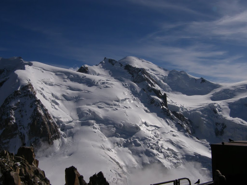
The view from the Aiguille du Midi is always breathtaking (well when it is not foggy) and I can see why people pay the 50 odd euros just to make the return trip. This photo shows the route we would follow the next day up Mont Blanc du Tacul, the col du Mont Maudit then to the summit of Mont Blanc.
{image:2}
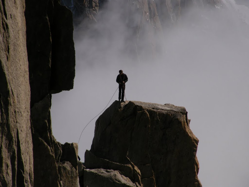
After sightseeing with the tourists on the observatin platform and admiring the “varappeurs” below the Aiguile du Midi it was time to head to the refuge. It was neary 17h30 and the last climbers were slaving up the ridge trying to make the last ride home rather than spend an icy night in the top station.
{image:3}
The ridge descends to the start of the Valley Blanche, you need to continue along the line of the ridge to avoid a rimaye (bergschrund) before doubling back to the south and the short climb to the Cosmiques (3613 m) refuge.
I put on my crampons and headed down to take some photos. Here are Luc, Richard and Benoit descending roped up. Richard is fairly new to crampon technique and was taking it easy.
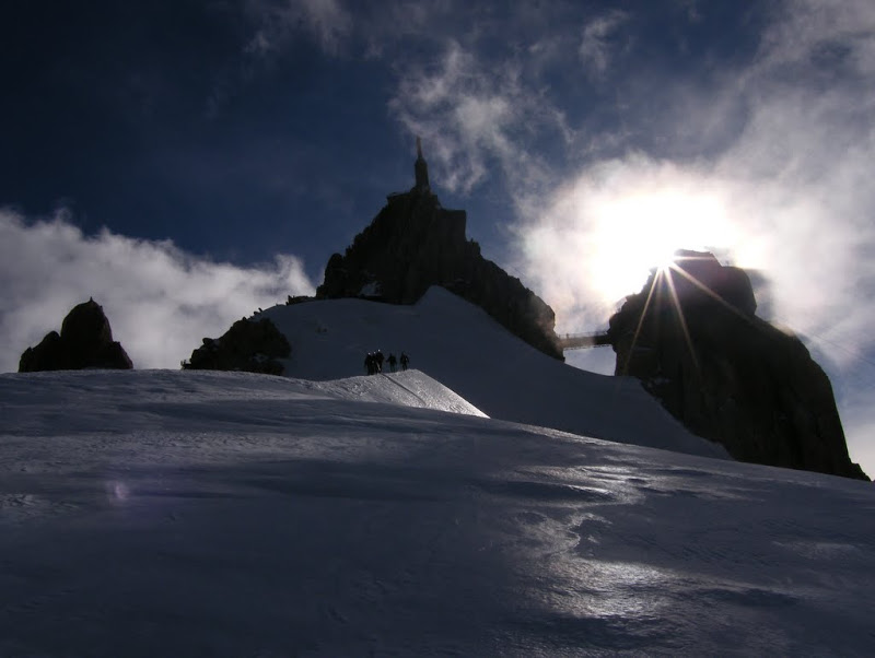
We left the refuge at 02h20, a bit late as there was quite a kerfuffle getting reading with a lot of guided zombies ambling round the refuge blocking doorways etc. It was not that cold, around zero at 3600 meters but a biting wind had got up from the North. We could see a long line of headlamps up the NW face of the Mont Blanc du Tacul (4028m). The snow was slightly loose on the surface as we began the climb which rapidly steepened but was never too steep. Towards the ridge a few crevasses and a rimaye appeared. The rimaye is usually crossed by a steep fixed ladder but we were able to avoid this on a snow bridge to the left. From the Tacul ridge you wind round to the left and then descend to a plateau to the col Maudit (4035m).
The Tacul offered much of the same, with steepening slopes, crevasses and rimayes. The track was well made and nothing was too difficult apart from the last 100 meters of ice climbing to the Col du Mont Maudit.
{image:4}
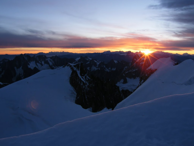
It is worth noting that the first part of the climb is covered in darkness and you don’t really see a lot. Dawn is arrived just after the difficult Tacul section. It was bitterly cold with a biting northerly wind blowing. I could not stop for more than a couple of minutes before starting to go numb on my face and fingers then arms and body. The only way to keep warm was to keep moving.
This is the hardest bit of the climb. Luc and Richard are leadng a group up the Tacul ice wall. It is around 55 degrees. The ice was pretty good for front pointing and held an axe well. The group in front of us kicked off a lot of ice boulders, hard to understand what they were doing as we didn’t dislodged anything. One boulder hit my helmet, leaving a large dent and another hurt my shoulder.
Luc and Benoit were pleased to finish with the crux and stop for a break. This section of the route has a number of fixed ropes but they were pretty mixed up. You can wait a long time here for climbers to clear the section and get very cold in the process. It is also a good point to slip on the way down with a large rimaye waiting to swallow you.
You again descend slightly to the Col de la Brenva (4303m) where there was another large crevasse. The day was dawning on Mont Blanc as the Three Amigos head over to the col de Brenva. Vincendon and Henry would have come here with Bonatti before their ill fated descent into the ice falls below the Vallot bivouac.
The route climbs the short but steep Mur de la Côte, just another 500 meters to the summit. Not far now.
Richard, Luc and Benoit make a rapid pit stop in the sun of the Brenva before the last lap.
Finally at the summit, at last. The air currents of France and Italy were doing battle. Here we see the updraft from Courmayer. The Three Monts involve a lot of climbing and traversing above 4000 meters with some exposure to ice fall and crevasses. The Maudit is extremely dangerous after fresh snow, even relatively small falls accompanied by wind can create and avalanche risk at any time of the year. It would be extremely hard to avoid either an avalanche or serac fall climbing the slopes and the crevasses and rimaye present serious terrain traps.
This is what it looks like to be under the lenticular cloud on the summit. Bizarre.
We descended via the Bosses ridge. The wind seemed less on this side and it was an easier route, at least at first. However in high winds we had heard of people climbing this ridge on all fours with ice axes.
Benoit at the end of the Gouter just before reaching the Vallot refuge. You can see the Lenticular cloud covering the summit of Mont Blanc.
The PGHM were flying a rescue mission at the Vallot to pick up a stricken climber suffering from the effects of altitude. One of many missions they were to fly over the weekend despite, or maybe because of, the excellent conditions. Four climbers killed and a Norwegian paraglider.
After the Vallot the trail was even marked with some wooden posts. It passes to the right of the Dome de Gouter before swinging around behind and then a long, gentle trot down to the Gouter refuge. There are still some crevasses but all were well bridged.
This is a good look at the route down from Mont Blanc via the Dome de Gouter and the glacier de Tete Rousse from above St Gervais. There is a couloir you have to cross (the Grand Couloir) which is well known for rockfall and is reputed to be one of the most dangerous zones in the Alps. Given the number of people crossing it is bit of a lottery who will get hit. However while we were on the Tete Rousse Glacier a large rockfall also swept down the main path from below the refuge du Gouter. The top of the path is protected by cables and is very steep and may still have snow and ice on it. The cables are not very practical if you want to clip onto them. You also spend a huge amount of time waiting for upclimbing hikers. The Tete Rousse glacier was in the process of being drained when we crossed, a water pocket of 85,000 liters that apparently threatened St Gervais with flooding. It has happened before. We then took the very rocky trail to the Nid d’Aigle stop where you can normally pick up the rack and pinion railway but due to works it is out of action above Mont Lachat. We were too late anyway and had a long walk down to Bellevue where we had a car (normally you can’t park higher than Biossonay). All in all 3200 meters of descent. We’d started at 2.20 am and been walking more or less non-stop for 17 hours.
Very cold on the climb. It only began to warm up a bit on the Col de Brenva at dawn. Otherwise not possible to stop for long on the climb. Climb was on ice or hard snow. Crevasses mostly bridged as was the rimaye under the Tacul. There were some fixed ropes on the harder sections.